Laguna Larga elevation
Laguna Larga (Guanajuato, Irapuato), Mexico elevation is 1704 meters and Laguna Larga elevation in feet is 5591 ft above sea level [src 1]. Laguna Larga is a populated place (feature code) with elevation that is 390 meters (1280 ft) bigger than average city elevation in Mexico.
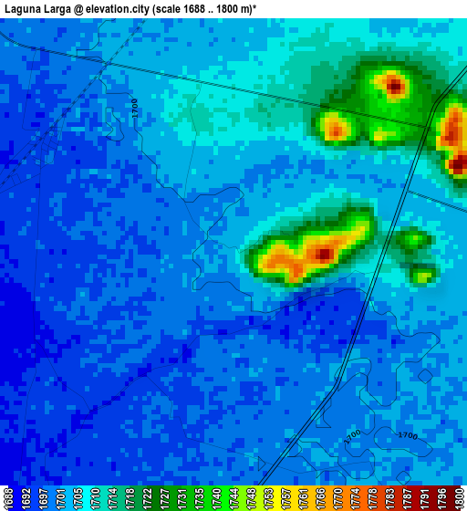
Below is the Elevation map of Laguna Larga, which displays elevation range with different colors. Scale of the first map is from 1688 to 1800 m (5538 to 5906 ft) with average elevation of 1703.6 meters (=5589 ft) [note 1]
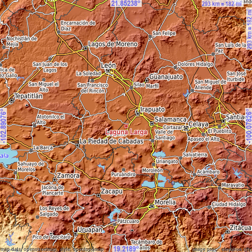
These maps also provides idea of topography and contour of this city, they are displayed at different zoom levels. More info about maps, scale and edge coordinates you can find below images.
| \ | Map #1 | Topo.Map |
| Scale [m] | 1688..1800 m | × |
| Scale [ft] | 5538..5906 ft | × |
| Average | 1703.6 m = 5589 ft | × |
| Width | 9.15 km = 5.7 mi | 292.8 km = 181.9 mi |
| Height | 9.15 km = 5.7 mi | 292.8 km = 181.9 mi |
| ↑Max Latitude | 20.582456° | 21.85238° |
| Latitude at center | 20.54131° | 20.54131° |
| ↓Min Latitude | 20.500153° | 19.2189° |
| ← Min Longitude | -101.528455° | -102.89076° |
| Longitude center | -101.48451° | -101.48451° |
| →Max Longitude | -101.440565° | -100.07826° |
Nearby cities:
Cities around Laguna Larga sort by population:
• Abasolo elevation 1712 m
11.2 km,  205°
205°
• Pueblo Nuevo 1710 m
11.9 km,  98°
98°
• Estación Joaquín 1695 m
4.3 km,  300°
300°
• Huitzatarito 1691 m
10.5 km,  238°
238°
• Las Masas (La Luz Masas) 1699 m
8.8 km,  316°
316°
• Guadalupe de Rivera 1717 m
7.3 km,  14°
14°
• La Soledad 1716 m
10.3 km,  44°
44°
• San Bernardo Peña Blanca 1727 m
8.9 km,  178°
178°
• Purísima de Covarrubias 1710 m
8.7 km,  0°
0°
• Colonia Morelos de Guadalupe de Rivera 1734 m
7.1 km,  31°
31°
• Peralta 1715 m
11 km,  133°
133°
• San Ignacio de Rivera (Ojo de Agua) 1711 m
3.1 km,  50°
50°
Multilingual:
 En español:
Laguna Larga elevación 1704 m.
 En France:
Laguna Larga élévation 1704 m.
 Auf Deutsch:
Laguna Larga höhe über dem Meeresspiegel ist 1704 m.

Sources and notes:
- [note 1] Map square and city borders are not equal. Map elevation data is calculated only from area inside that square.
- [src 1] Elevation data from geonames database provided with same terms of usage.
- [src 2] The elevation map of Laguna Larga is generated using elevation data from NASA's 3 arcsec (90m) resolution SRTM data.
- [src 3] Base (background) map © OpenStreetMap contributors tiles are generated by Geofabrik and OpenTopoMap.
Copyright & License:
This Laguna Larga Elevation Map is licensed under CC BY-SA. You may reuse any part from this page, if you give a proper credit by linking to this URL:
 More info on terms of use page.