La Capilla elevation
La Capilla (Guanajuato, Salamanca), Mexico elevation is 1710 meters and La Capilla elevation in feet is 5610 ft above sea level [src 1]. La Capilla is a populated place (feature code) with elevation that is 396 meters (1299 ft) bigger than average city elevation in Mexico.
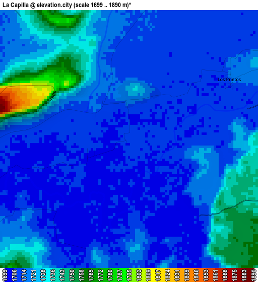
Below is the Elevation map of La Capilla, which displays elevation range with different colors. Scale of the first map is from 1699 to 1890 m (5574 to 6201 ft) with average elevation of 1718.7 meters (=5639 ft) [note 1]
These maps also provides idea of topography and contour of this city, they are displayed at different zoom levels. More info about maps, scale and edge coordinates you can find below images.
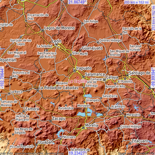
| \ | Map #1 | Topo.Map |
| Scale [m] | 1699..1890 m | × |
| Scale [ft] | 5574..6201 ft | × |
| Average | 1718.7 m = 5639 ft | × |
| Width | 9.15 km = 5.7 mi | 292.8 km = 181.9 mi |
| Height | 9.15 km = 5.7 mi | 292.8 km = 181.9 mi |
| ↑Max Latitude | 20.597692° | 21.86749° |
| Latitude at center | 20.55655° | 20.55655° |
| ↓Min Latitude | 20.515397° | 19.23427° |
| ← Min Longitude | -101.344135° | -102.70644° |
| Longitude center | -101.30019° | -101.30019° |
| →Max Longitude | -101.256245° | -99.89394° |
Nearby cities:
Cities around La Capilla sort by population:
• Salamanca elevation 1714 m
11.4 km,  81°
81°
• San Roque 1729 m
6.5 km,  317°
317°
• Loma Pelada 1715 m
1.9 km,  19°
19°
• Pueblo Nuevo 1710 m
8.2 km,  244°
244°
• Los Prietos 1715 m
4.1 km,  60°
60°
• Tomelopitos 1713 m
8.3 km,  300°
300°
• Cuarta Brigada 1714 m
7.6 km, 16°
• Cárdenas 1715 m
11.7 km,  45°
45°
• San Antonio el Chico 1717 m
8.1 km,  12°
12°
• La Tinaja 1723 m
11.5 km,  129°
129°
• Santa Bárbara 1701 m
10.4 km,  209°
209°
• San Vicente de Flores 1715 m
8.8 km,  34°
34°
Multilingual:
 En español:
La Capilla elevación 1710 m.
 En France:
La Capilla élévation 1710 m.
 Auf Deutsch:
La Capilla höhe über dem Meeresspiegel ist 1710 m.

Sources and notes:
- [note 1] Map square and city borders are not equal. Map elevation data is calculated only from area inside that square.
- [src 1] Elevation data from geonames database provided with same terms of usage.
- [src 2] The elevation map of La Capilla is generated using elevation data from NASA's 3 arcsec (90m) resolution SRTM data.
- [src 3] Base (background) map © OpenStreetMap contributors tiles are generated by Geofabrik and OpenTopoMap.
Copyright & License:
This La Capilla Elevation Map is licensed under CC BY-SA. You may reuse any part from this page, if you give a proper credit by linking to this URL:
 More info on terms of use page.