Loza de los Padres elevation
Loza de los Padres (Guanajuato, León), Mexico elevation is 1857 meters and Loza de los Padres elevation in feet is 6093 ft above sea level [src 1]. Loza de los Padres is a populated place (feature code) with elevation that is 543 meters (1781 ft) bigger than average city elevation in Mexico.
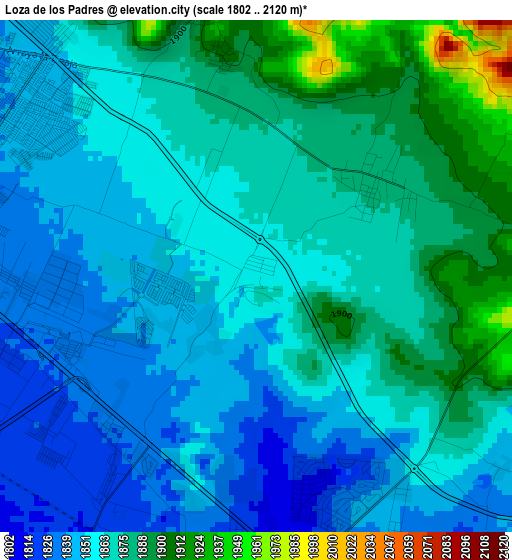
Below is the Elevation map of Loza de los Padres, which displays elevation range with different colors. Scale of the first map is from 1802 to 2120 m (5912 to 6955 ft) with average elevation of 1864.4 meters (=6117 ft) [note 1]
These maps also provides idea of topography and contour of this city, they are displayed at different zoom levels. More info about maps, scale and edge coordinates you can find below images.
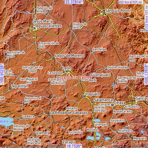
| \ | Map #1 | Topo.Map |
| Scale [m] | 1802..2120 m | × |
| Scale [ft] | 5912..6955 ft | × |
| Average | 1864.4 m = 6117 ft | × |
| Width | 9.12 km = 5.7 mi | 291.8 km = 181.3 mi |
| Height | 9.12 km = 5.7 mi | 291.8 km = 181.3 mi |
| ↑Max Latitude | 21.112811° | 22.37814° |
| Latitude at center | 21.07181° | 21.07181° |
| ↓Min Latitude | 21.030798° | 19.7539° |
| ← Min Longitude | -101.589975° | -102.95228° |
| Longitude center | -101.54603° | -101.54603° |
| →Max Longitude | -101.502085° | -100.13978° |
Nearby cities:
Cities around Loza de los Padres sort by population:
• Duarte elevation 1882 m
2.8 km,  52°
52°
• Comanjilla 1887 m
7.6 km,  95°
95°
• San Juan de Otates 1902 m
5 km,  346°
346°
• San Francisco (Baños de Agua Caliente) 1901 m
7.6 km,  88°
88°
• San Isidro de los Sauces 1798 m
5.7 km,  170°
170°
• Ladrilleras del Refugio 1862 m
1.6 km,  331°
331°
• San José del Potrero 1848 m
8.2 km,  319°
319°
• La Laborcita 1910 m
3.9 km, 351°
• El Refugio de los Sauces 1798 m
6.5 km, 166°
• Mezquite de Sotelo 1799 m
8.4 km,  147°
147°
• Lucio Blanco (Los Gavilanes) 1920 m
4.9 km, 353°
• Fraccionamiento Paraíso Real 1851 m
5.8 km, 321°
Multilingual:
 En español:
Loza de los Padres elevación 1857 m.
 En France:
Loza de los Padres élévation 1857 m.
 Auf Deutsch:
Loza de los Padres höhe über dem Meeresspiegel ist 1857 m.
 На русском:
Loza de los Padres высота над уровнем моря 1857 м
Sources and notes:
- [note 1] Map square and city borders are not equal. Map elevation data is calculated only from area inside that square.
- [src 1] Elevation data from geonames database provided with same terms of usage.
- [src 2] The elevation map of Loza de los Padres is generated using elevation data from NASA's 3 arcsec (90m) resolution SRTM data.
- [src 3] Base (background) map © OpenStreetMap contributors tiles are generated by Geofabrik and OpenTopoMap.
Copyright & License:
This Loza de los Padres Elevation Map is licensed under CC BY-SA. You may reuse any part from this page, if you give a proper credit by linking to this URL:
 More info on terms of use page.