Salitrillo elevation
Salitrillo (Guanajuato, Silao de la Victoria), Mexico elevation is 1836 meters and Salitrillo elevation in feet is 6024 ft above sea level [src 1]. Salitrillo is a populated place (feature code) with elevation that is 522 meters (1713 ft) bigger than average city elevation in Mexico.
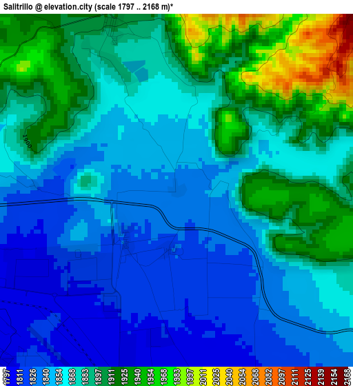
Below is the Elevation map of Salitrillo, which displays elevation range with different colors. Scale of the first map is from 1797 to 2168 m (5896 to 7113 ft) with average elevation of 1872.9 meters (=6145 ft) [note 1]
These maps also provides idea of topography and contour of this city, they are displayed at different zoom levels. More info about maps, scale and edge coordinates you can find below images.
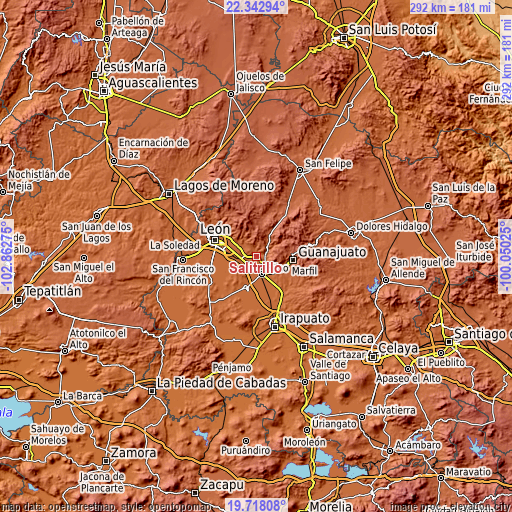
| \ | Map #1 | Topo.Map |
| Scale [m] | 1797..2168 m | × |
| Scale [ft] | 5896..7113 ft | × |
| Average | 1872.9 m = 6145 ft | × |
| Width | 9.12 km = 5.7 mi | 291.9 km = 181.4 mi |
| Height | 9.12 km = 5.7 mi | 291.9 km = 181.4 mi |
| ↑Max Latitude | 21.077301° | 22.34294° |
| Latitude at center | 21.03629° | 21.03629° |
| ↓Min Latitude | 20.995268° | 19.71808° |
| ← Min Longitude | -101.500445° | -102.86275° |
| Longitude center | -101.4565° | -101.4565° |
| →Max Longitude | -101.412555° | -100.05025° |
Nearby cities:
Cities around Salitrillo sort by population:
• Colonia Nuevo México elevation 1797 m
6.5 km,  207°
207°
• Comanjilla 1887 m
3.6 km,  331°
331°
• Chichimequillas 1859 m
1.4 km,  86°
86°
• San Francisco (Baños de Agua Caliente) 1901 m
4.5 km,  337°
337°
• San Antonio Texas 1798 m
6.6 km, 211°
• Providencia de Nápoles 1826 m
1.5 km,  185°
185°
• Mezquite de Sotelo 1799 m
5.7 km,  237°
237°
• San Miguel del Arenal 1803 m
5.9 km, 210°
• Monte del Coecillo 1805 m
6.7 km,  161°
161°
• San Agustín de las Flores 1824 m
3.8 km,  148°
148°
• Paxtle 1896 m
6 km,  65°
65°
• Loma de Yerbabuena 1889 m
2.8 km,  15°
15°
Multilingual:
 En español:
Salitrillo elevación 1836 m.
 En France:
Salitrillo élévation 1836 m.
 Auf Deutsch:
Salitrillo höhe über dem Meeresspiegel ist 1836 m.

Sources and notes:
- [note 1] Map square and city borders are not equal. Map elevation data is calculated only from area inside that square.
- [src 1] Elevation data from geonames database provided with same terms of usage.
- [src 2] The elevation map of Salitrillo is generated using elevation data from NASA's 3 arcsec (90m) resolution SRTM data.
- [src 3] Base (background) map © OpenStreetMap contributors tiles are generated by Geofabrik and OpenTopoMap.
Copyright & License:
This Salitrillo Elevation Map is licensed under CC BY-SA. You may reuse any part from this page, if you give a proper credit by linking to this URL:
 More info on terms of use page.