Altar elevation
Altar (Sonora), Mexico elevation is 419 meters and Altar elevation in feet is 1375 ft above sea level [src 1]. Altar is a seat of a second-order administrative division (feature code) with elevation that is 895 meters (2936 ft) smaller than average city elevation in Mexico.
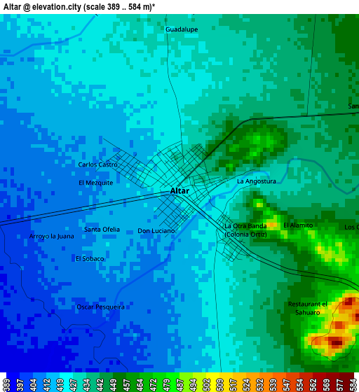
Below is the Elevation map of Altar, which displays elevation range with different colors. Scale of the first map is from 389 to 584 m (1276 to 1916 ft) with average elevation of 426.9 meters (=1401 ft) [note 1]
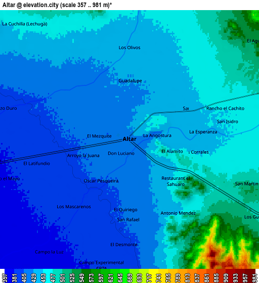
These maps also provides idea of topography and contour of this city, they are displayed at different zoom levels. More info about maps, scale and edge coordinates you can find below images.
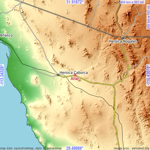
| \ | Map #1 | Map #2 | Topo.Map |
| Scale [m] | 389..584 m | 357..981 m | × |
| Scale [ft] | 1276..1916 ft | 1171..3219 ft | × |
| Average | 426.9 m = 1401 ft | 445.6 m = 1462 ft | × |
| Width | 8.4 km = 5.2 mi | 16.8 km = 10.4 mi | 268.8 km = 167 mi |
| Height | 8.4 km = 5.2 mi | 16.8 km = 10.4 mi | 268.8 km = 167 mi |
| ↑Max Latitude | 30.753153° | 30.790911° | 31.91672° |
| Latitude at center | 30.71538° | 30.71538° | 30.71538° |
| ↓Min Latitude | 30.677592° | 30.63979° | 29.49889° |
| ← Min Longitude | -111.880975° | -111.924921° | -113.24328° |
| Longitude center | -111.83703° | -111.83703° | -111.83703° |
| →Max Longitude | -111.793085° | -111.749139° | -110.43078° |
Nearby cities:
Cities around Altar sort by population:
• Heroica Caborca elevation 288 m
30.7 km,  270°
270°
• Magdalena de Kino 771 m
84.2 km,  96°
96°
• Santa Ana 694 m
71.4 km,  105°
105°
• Pitiquito 318 m
21.2 km,  258°
258°
• El Diamante (La Retranca) 125 m
78 km,  280°
280°
• El Coyote 130 m
75.4 km, 279°
• Estación Llano 705 m
80.5 km,  119°
119°
• Trincheras 505 m
45.9 km,  140°
140°
• Sáric 780 m
61.4 km,  45°
45°
• Atil 568 m
28.1 km,  59°
59°
• Oquitoa 478 m
10.2 km,  73°
73°
• Tubutama 650 m
40.2 km, 62°
Multilingual:
 En español:
Altar elevación 419 m.
 En France:
Altar élévation 419 m.


Sources and notes:
- [note 1] Map square and city borders are not equal. Map elevation data is calculated only from area inside that square.
- [src 1] Elevation data from geonames database provided with same terms of usage.
- [src 2] The elevation map of Altar is generated using elevation data from NASA's 3 arcsec (90m) resolution SRTM data.
- [src 3] Base (background) map © OpenStreetMap contributors tiles are generated by Geofabrik and OpenTopoMap.
Copyright & License:
This Altar Elevation Map is licensed under CC BY-SA. You may reuse any part from this page, if you give a proper credit by linking to this URL:
 More info on terms of use page.