Antonio Amaro elevation
Antonio Amaro (Durango, Guadalupe Victoria), Mexico elevation is 2102 meters and Antonio Amaro elevation in feet is 6896 ft above sea level [src 1]. Antonio Amaro is a populated place (feature code) with elevation that is 788 meters (2585 ft) bigger than average city elevation in Mexico.
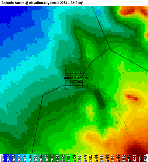
Below is the Elevation map of Antonio Amaro, which displays elevation range with different colors. Scale of the first map is from 2033 to 2219 m (6670 to 7280 ft) with average elevation of 2099.6 meters (=6888 ft) [note 1]
These maps also provides idea of topography and contour of this city, they are displayed at different zoom levels. More info about maps, scale and edge coordinates you can find below images.
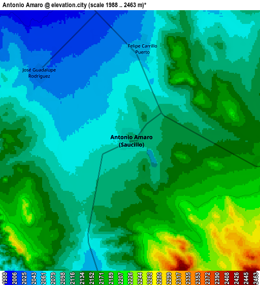
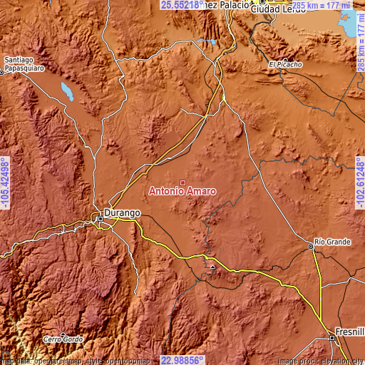
| \ | Map #1 | Map #2 | Topo.Map |
| Scale [m] | 2033..2219 m | 1988..2463 m | × |
| Scale [ft] | 6670..7280 ft | 6522..8081 ft | × |
| Average | 2099.6 m = 6888 ft | 2119.4 m = 6953 ft | × |
| Width | 8.91 km = 5.5 mi | 17.82 km = 11.1 mi | 285 km = 177.1 mi |
| Height | 8.91 km = 5.5 mi | 17.82 km = 11.1 mi | 285.1 km = 177.2 mi |
| ↑Max Latitude | 24.316893° | 24.356933° | 25.55218° |
| Latitude at center | 24.27684° | 24.27684° | 24.27684° |
| ↓Min Latitude | 24.236774° | 24.196696° | 22.98856° |
| ← Min Longitude | -104.062675° | -104.106621° | -105.42498° |
| Longitude center | -104.01873° | -104.01873° | -104.01873° |
| →Max Longitude | -103.974785° | -103.930839° | -102.61248° |
Nearby cities:
Cities around Antonio Amaro sort by population:
• Ciudad Guadalupe Victoria elevation 2001 m
21.3 km,  330°
330°
• Francisco I. Madero 1957 m
33.5 km,  294°
294°
• Cuauhtemoc 2172 m
21.3 km,  85°
85°
• Ignacio Allende 1968 m
22.1 km,  5°
5°
• Ignacio Ramírez 2038 m
26.6 km,  344°
344°
• General Calixto Contreras 1981 m
17.2 km,  350°
350°
• Emiliano Zapata 2029 m
22.7 km,  35°
35°
• Felipe Carrillo Puerto 2049 m
6.3 km, 7°
• Cieneguillas 1976 m
24.9 km,  187°
187°
• San Atenógenes (La Villita) 1931 m
31.8 km,  179°
179°
• José Guadalupe Rodríguez 2029 m
7.8 km,  307°
307°
• Narciso Mendoza 1968 m
29.8 km,  169°
169°
Multilingual:
 En español:
Antonio Amaro elevación 2102 m.
 En France:
Antonio Amaro élévation 2102 m.
 Auf Deutsch:
Antonio Amaro höhe über dem Meeresspiegel ist 2102 m.

Sources and notes:
- [note 1] Map square and city borders are not equal. Map elevation data is calculated only from area inside that square.
- [src 1] Elevation data from geonames database provided with same terms of usage.
- [src 2] The elevation map of Antonio Amaro is generated using elevation data from NASA's 3 arcsec (90m) resolution SRTM data.
- [src 3] Base (background) map © OpenStreetMap contributors tiles are generated by Geofabrik and OpenTopoMap.
Copyright & License:
This Antonio Amaro Elevation Map is licensed under CC BY-SA. You may reuse any part from this page, if you give a proper credit by linking to this URL:
 More info on terms of use page.