Ciudad de Armería elevation
Ciudad de Armería (Colima, Armería), Mexico elevation is 32 meters and Ciudad de Armería elevation in feet is 105 ft above sea level [src 1]. Ciudad de Armería is a seat of a second-order administrative division (feature code) with elevation that is 1282 meters (4206 ft) smaller than average city elevation in Mexico.
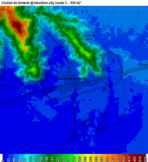
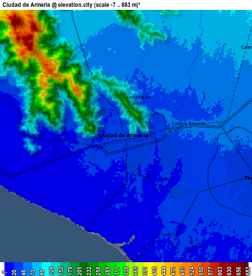
Below is the Elevation map of Ciudad de Armería, which displays elevation range with different colors. Scale of the first map is from 3 to 534 m (10 to 1752 ft) with average elevation of 60.3 meters (=198 ft) [note 1]
These maps also provides idea of topography and contour of this city, they are displayed at different zoom levels. More info about maps, scale and edge coordinates you can find below images.
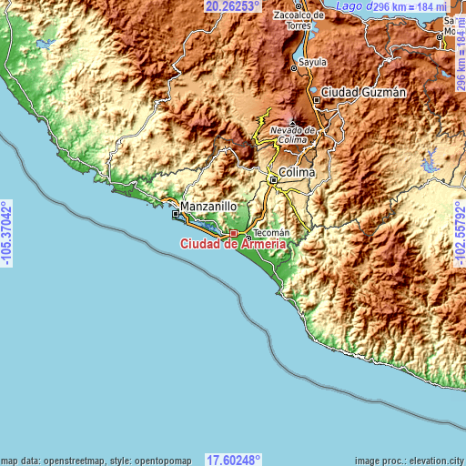
| \ | Map #1 | Map #2 | Topo.Map |
| Scale [m] | 3..534 m | -7..683 m | × |
| Scale [ft] | 10..1752 ft | -23..2241 ft | × |
| Average | 60.3 m = 198 ft | 78.3 m = 257 ft | × |
| Width | 9.24 km = 5.7 mi | 18.49 km = 11.5 mi | 295.8 km = 183.8 mi |
| Height | 9.24 km = 5.7 mi | 18.49 km = 11.5 mi | 295.8 km = 183.8 mi |
| ↑Max Latitude | 18.979361° | 19.020913° | 20.26253° |
| Latitude at center | 18.9378° | 18.9378° | 18.9378° |
| ↓Min Latitude | 18.896228° | 18.854646° | 17.60248° |
| ← Min Longitude | -104.008115° | -104.052061° | -105.37042° |
| Longitude center | -103.96417° | -103.96417° | -103.96417° |
| →Max Longitude | -103.920225° | -103.876279° | -102.55792° |
Nearby cities:
Cities around Ciudad de Armería sort by population:
• Tecomán elevation 40 m
9.4 km,  104°
104°
• Cerro de Ortega 17 m
32.9 km,  129°
129°
• Cofradía de Juárez 51 m
2.9 km,  18°
18°
• Madrid 183 m
19 km,  30°
30°
• Rincón de López 126 m
13.2 km,  14°
14°
• Ixtlahuacán 167 m
25 km,  73°
73°
• Pueblo Juárez (La Magdalena) 271 m
25.7 km, 7°
• Cofradía de Morelos 25 m
15.5 km,  120°
120°
• Caleras 81 m
11.1 km,  53°
53°
• Venustiano Carranza 17 m
17.4 km,  297°
297°
• Augusto Gómez Villanueva 101 m
10.1 km,  337°
337°
• Cuyutlán 8 m
11.2 km,  259°
259°
Multilingual:
 En español:
Armeria, Ciudad de Armería elevación 32 m.
 En France:
Ciudad de Armería élévation 32 m.
 Auf Deutsch:
Ciudad de Armería höhe über dem Meeresspiegel ist 32 m.

Sources and notes:
- [note 1] Map square and city borders are not equal. Map elevation data is calculated only from area inside that square.
- [src 1] Elevation data from geonames database provided with same terms of usage.
- [src 2] The elevation map of Ciudad de Armería is generated using elevation data from NASA's 3 arcsec (90m) resolution SRTM data.
- [src 3] Base (background) map © OpenStreetMap contributors tiles are generated by Geofabrik and OpenTopoMap.
Copyright & License:
This Ciudad de Armería Elevation Map is licensed under CC BY-SA. You may reuse any part from this page, if you give a proper credit by linking to this URL:
 More info on terms of use page.