Atotonilquillo elevation
Atotonilquillo (Jalisco, Chapala), Mexico elevation is 1528 meters and Atotonilquillo elevation in feet is 5013 ft above sea level [src 1]. Atotonilquillo is a populated place (feature code) with elevation that is 214 meters (702 ft) bigger than average city elevation in Mexico.
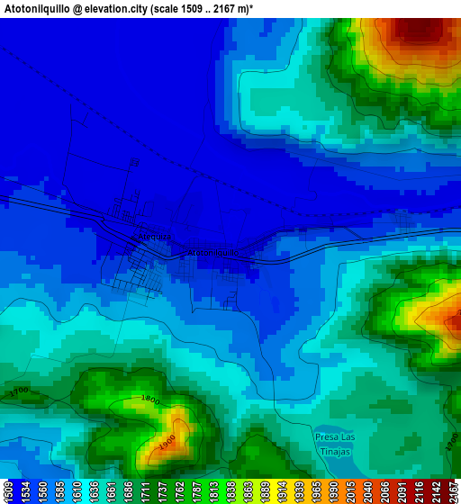
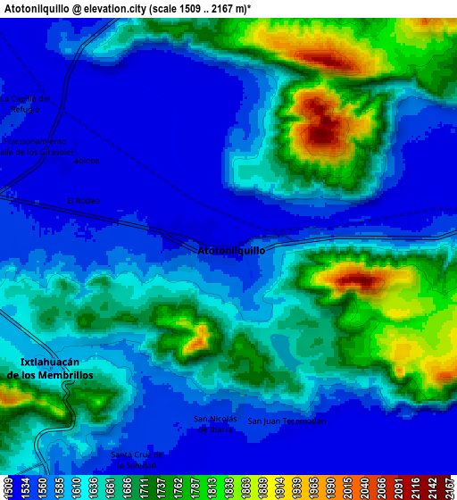
Below is the Elevation map of Atotonilquillo, which displays elevation range with different colors. Scale of the first map is from 1509 to 2167 m (4951 to 7110 ft) with average elevation of 1622.4 meters (=5323 ft) [note 1]
These maps also provides idea of topography and contour of this city, they are displayed at different zoom levels. More info about maps, scale and edge coordinates you can find below images.
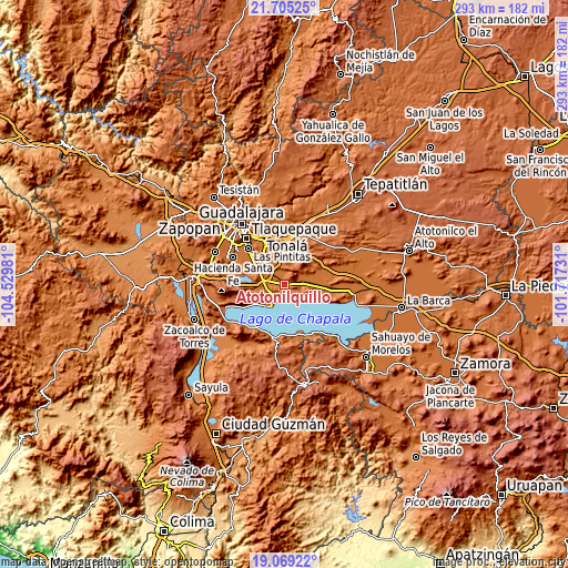
| \ | Map #1 | Map #2 | Topo.Map |
| Scale [m] | 1509..2167 m | 1509..2167 m | × |
| Scale [ft] | 4951..7110 ft | 4951..7110 ft | × |
| Average | 1622.4 m = 5323 ft | 1632.8 m = 5357 ft | × |
| Width | 9.16 km = 5.7 mi | 18.32 km = 11.4 mi | 293.1 km = 182.1 mi |
| Height | 9.16 km = 5.7 mi | 18.32 km = 11.4 mi | 293.1 km = 182.1 mi |
| ↑Max Latitude | 20.434056° | 20.47523° | 21.70525° |
| Latitude at center | 20.39287° | 20.39287° | 20.39287° |
| ↓Min Latitude | 20.351673° | 20.310466° | 19.06922° |
| ← Min Longitude | -103.167505° | -103.211451° | -104.52981° |
| Longitude center | -103.12356° | -103.12356° | -103.12356° |
| →Max Longitude | -103.079615° | -103.035669° | -101.71731° |
Nearby cities:
Cities around Atotonilquillo sort by population:
• Atequiza elevation 1557 m
1.8 km,  260°
260°
• Ixtlahuacán de los Membrillos 1601 m
8.8 km,  235°
235°
• Los Cedros 1575 m
11.4 km,  268°
268°
• San Juan Tecomatlán 1532 m
7.6 km,  161°
161°
• Buenavista 1562 m
9.6 km, 263°
• Santa Cruz de la Soledad 1543 m
9.1 km,  203°
203°
• San Jacinto 1534 m
7 km,  85°
85°
• Valle de los Girasoles [Fraccionamiento] 1525 m
8.7 km,  295°
295°
• San Nicolás de Ibarra 1535 m
7 km,  184°
184°
• El Rodeo 1523 m
6.1 km,  287°
287°
• Santa Rosa 1550 m
11.9 km,  281°
281°
• Tecualtitán 1526 m
10.6 km,  70°
70°
Multilingual:
 En español:
Atotonilquillo elevación 1528 m.
 En France:
Atotonilquillo élévation 1528 m.
 Auf Deutsch:
Atotonilquillo höhe über dem Meeresspiegel ist 1528 m.

Sources and notes:
- [note 1] Map square and city borders are not equal. Map elevation data is calculated only from area inside that square.
- [src 1] Elevation data from geonames database provided with same terms of usage.
- [src 2] The elevation map of Atotonilquillo is generated using elevation data from NASA's 3 arcsec (90m) resolution SRTM data.
- [src 3] Base (background) map © OpenStreetMap contributors tiles are generated by Geofabrik and OpenTopoMap.
Copyright & License:
This Atotonilquillo Elevation Map is licensed under CC BY-SA. You may reuse any part from this page, if you give a proper credit by linking to this URL:
 More info on terms of use page.