Villa Juárez elevation
Villa Juárez (Sinaloa, Navolato), Mexico elevation is 12 meters and Villa Juárez elevation in feet is 39 ft above sea level [src 1]. Villa Juárez is a populated place (feature code) with elevation that is 1302 meters (4272 ft) smaller than average city elevation in Mexico.
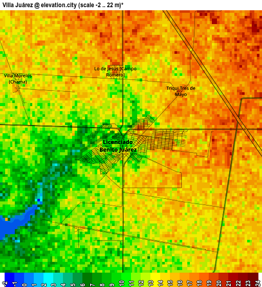
Below is the Elevation map of Villa Juárez, which displays elevation range with different colors. Scale of the first map is from -2 to 22 m (-7 to 72 ft) with average elevation of 13.2 meters (=43 ft) [note 1]
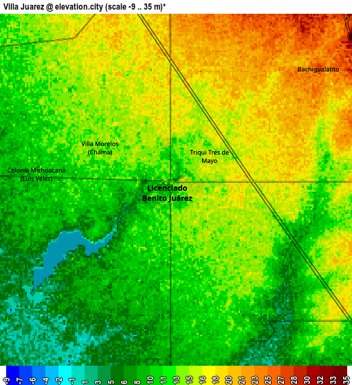
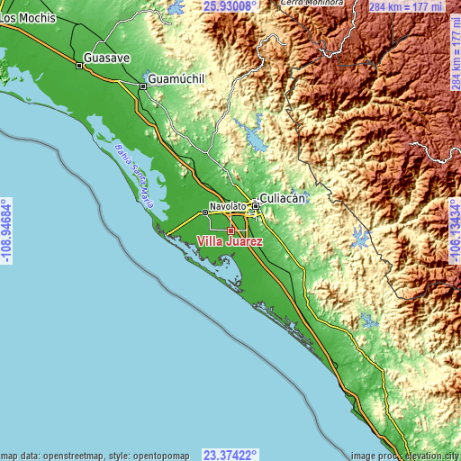
These maps also provides idea of topography and contour of this city, they are displayed at different zoom levels. More info about maps, scale and edge coordinates you can find below images.
| \ | Map #1 | Map #2 | Topo.Map |
| Scale [m] | -2..22 m | -9..35 m | × |
| Scale [ft] | -7..72 ft | -30..115 ft | × |
| Average | 13.2 m = 43 ft | 12.9 m = 42 ft | × |
| Width | 8.88 km = 5.5 mi | 17.76 km = 11 mi | 284.2 km = 176.6 mi |
| Height | 8.88 km = 5.5 mi | 17.76 km = 11 mi | 284.2 km = 176.6 mi |
| ↑Max Latitude | 24.698622° | 24.73854° | 25.93008° |
| Latitude at center | 24.65869° | 24.65869° | 24.65869° |
| ↓Min Latitude | 24.618746° | 24.578789° | 23.37422° |
| ← Min Longitude | -107.584535° | -107.628481° | -108.94684° |
| Longitude center | -107.54059° | -107.54059° | -107.54059° |
| →Max Longitude | -107.496645° | -107.452699° | -106.13434° |
Nearby cities:
Cities around Villa Juárez sort by population:
• Villa de Costa Rica elevation 31 m
17.1 km,  115°
115°
• Licenciado Benito Juárez (Campo Gobierno) 11 m
0.5 km,  243°
243°
• El Diez 31 m
11.5 km,  51°
51°
• Culiacancito 33 m
18.5 km,  1°
1°
• Cofradía de Navolato (Cofradía de los Rocha) 19 m
16.3 km,  318°
318°
• Campo Balbuena 25 m
9.8 km,  354°
354°
• El Potrero de Sataya 13 m
17.4 km,  281°
281°
• Colonia Michoacana 13 m
11.8 km,  308°
308°
• El Molino 11 m
15.9 km,  232°
232°
• Bariometo 20 m
17.2 km, 314°
• Lo de Jesús (Campo Romero) 17 m
2.4 km, 348°
• Bachigualatito 27 m
9.4 km, 49°
Multilingual:
 En español:
Villa Juárez elevación 12 m.
 En France:
Villa Juárez élévation 12 m.
 Auf Deutsch:
Villa Juárez höhe über dem Meeresspiegel ist 12 m.

Sources and notes:
- [note 1] Map square and city borders are not equal. Map elevation data is calculated only from area inside that square.
- [src 1] Elevation data from geonames database provided with same terms of usage.
- [src 2] The elevation map of Villa Juárez is generated using elevation data from NASA's 3 arcsec (90m) resolution SRTM data.
- [src 3] Base (background) map © OpenStreetMap contributors tiles are generated by Geofabrik and OpenTopoMap.
Copyright & License:
This Villa Juárez Elevation Map is licensed under CC BY-SA. You may reuse any part from this page, if you give a proper credit by linking to this URL:
 More info on terms of use page.