Churipitzeo elevation
Churipitzeo (Guanajuato, Pénjamo), Mexico elevation is 1770 meters and Churipitzeo elevation in feet is 5807 ft above sea level [src 1]. Churipitzeo is a populated place (feature code) with elevation that is 456 meters (1496 ft) bigger than average city elevation in Mexico.
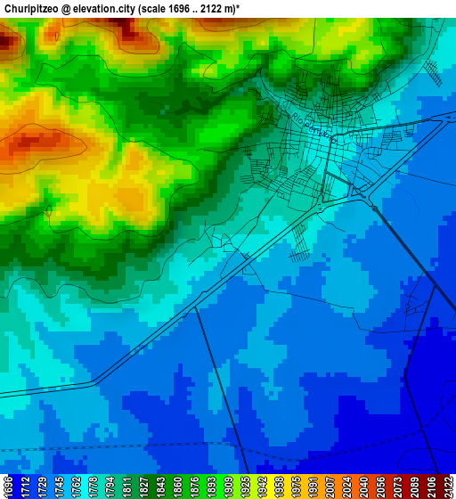
Below is the Elevation map of Churipitzeo, which displays elevation range with different colors. Scale of the first map is from 1696 to 2122 m (5564 to 6962 ft) with average elevation of 1801.4 meters (=5910 ft) [note 1]
These maps also provides idea of topography and contour of this city, they are displayed at different zoom levels. More info about maps, scale and edge coordinates you can find below images.
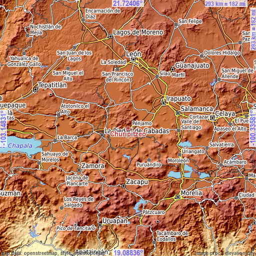
| \ | Map #1 | Topo.Map |
| Scale [m] | 1696..2122 m | × |
| Scale [ft] | 5564..6962 ft | × |
| Average | 1801.4 m = 5910 ft | × |
| Width | 9.16 km = 5.7 mi | 293.1 km = 182.1 mi |
| Height | 9.16 km = 5.7 mi | 293.1 km = 182.1 mi |
| ↑Max Latitude | 20.45303° | 21.72406° |
| Latitude at center | 20.41185° | 20.41185° |
| ↓Min Latitude | 20.370659° | 19.08836° |
| ← Min Longitude | -101.786005° | -103.14831° |
| Longitude center | -101.74206° | -101.74206° |
| →Max Longitude | -101.698115° | -100.33581° |
Nearby cities:
Cities around Churipitzeo sort by population:
• Pénjamo elevation 1771 m
2.9 km,  43°
43°
• Estación Pénjamo 1706 m
5.6 km,  110°
110°
• La Estrella 1680 m
18.8 km,  262°
262°
• La Calle 1702 m
17.8 km,  141°
141°
• Buenavista de Cortés 1703 m
14 km,  252°
252°
• San Gabriel y San Ignacio 1691 m
14.3 km,  77°
77°
• Zapote de Cestao 1813 m
10.5 km, 40°
• El Varal 1693 m
16.4 km,  115°
115°
• Colonia Morelos 1679 m
17.1 km, 253°
• Zapote de Barajas 1703 m
6 km,  132°
132°
• Las Ánimas 1780 m
6.2 km, 254°
• Estación Corralejo 1694 m
14.6 km,  63°
63°
Multilingual:
 En español:
Churipitzeo elevación 1770 m.
 En France:
Churipitzeo élévation 1770 m.
 Auf Deutsch:
Churipitzeo höhe über dem Meeresspiegel ist 1770 m.

Sources and notes:
- [note 1] Map square and city borders are not equal. Map elevation data is calculated only from area inside that square.
- [src 1] Elevation data from geonames database provided with same terms of usage.
- [src 2] The elevation map of Churipitzeo is generated using elevation data from NASA's 3 arcsec (90m) resolution SRTM data.
- [src 3] Base (background) map © OpenStreetMap contributors tiles are generated by Geofabrik and OpenTopoMap.
Copyright & License:
This Churipitzeo Elevation Map is licensed under CC BY-SA. You may reuse any part from this page, if you give a proper credit by linking to this URL:
 More info on terms of use page.