Vicente Guerrero elevation
Vicente Guerrero (Baja California, Ensenada), Mexico elevation is 28 meters and Vicente Guerrero elevation in feet is 92 ft above sea level [src 1]. Vicente Guerrero is a populated place (feature code) with elevation that is 1286 meters (4219 ft) smaller than average city elevation in Mexico.
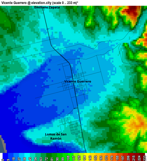
Below is the Elevation map of Vicente Guerrero, which displays elevation range with different colors. Scale of the first map is from 0 to 233 m (0 to 764 ft) with average elevation of 50.2 meters (=165 ft) [note 1]
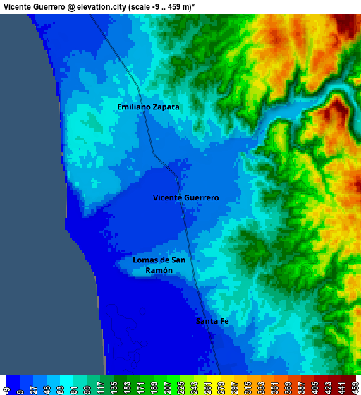
These maps also provides idea of topography and contour of this city, they are displayed at different zoom levels. More info about maps, scale and edge coordinates you can find below images.
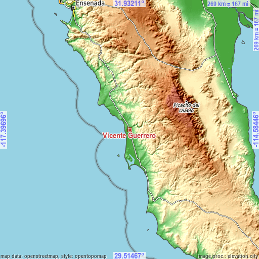
| \ | Map #1 | Map #2 | Topo.Map |
| Scale [m] | 0..233 m | -9..459 m | × |
| Scale [ft] | 0..764 ft | -30..1506 ft | × |
| Average | 50.2 m = 165 ft | 106.1 m = 348 ft | × |
| Width | 8.4 km = 5.2 mi | 16.8 km = 10.4 mi | 268.8 km = 167 mi |
| Height | 8.4 km = 5.2 mi | 16.8 km = 10.4 mi | 268.8 km = 167 mi |
| ↑Max Latitude | 30.768737° | 30.806489° | 31.93211° |
| Latitude at center | 30.73097° | 30.73097° | 30.73097° |
| ↓Min Latitude | 30.693188° | 30.655392° | 29.51467° |
| ← Min Longitude | -116.034655° | -116.078601° | -117.39696° |
| Longitude center | -115.99071° | -115.99071° | -115.99071° |
| →Max Longitude | -115.946765° | -115.902819° | -114.58446° |
Nearby cities:
Cities around Vicente Guerrero sort by population:
• Lázaro Cárdenas elevation 24 m
23.4 km,  164°
164°
• Camalú 32 m
14.2 km,  330°
330°
• Emiliano Zapata 41 m
2.8 km,  335°
335°
• San Quintín 22 m
18.2 km,  166°
166°
• Colonia Lomas de San Ramón (Triquis) 47 m
3.5 km,  199°
199°
• Colonia Nueva Era 17 m
25.8 km, 165°
• Santa Fé 18 m
5.8 km, 166°
• Poblado Chulavista (El Chorizo) 34 m
2.2 km, 326°
• La Providencia 49 m
30.9 km, 328°
• Ejido General Leandro Valle 20 m
12.4 km, 168°
• Las Brisas 36 m
30.4 km, 326°
• Pueblo Benito García 17 m
24.6 km, 166°
Multilingual:
 En español:
Vicente Guerrero elevación 28 m.
 En France:
Vicente Guerrero élévation 28 m.
 Auf Deutsch:
Vicente Guerrero höhe über dem Meeresspiegel ist 28 m.

Sources and notes:
- [note 1] Map square and city borders are not equal. Map elevation data is calculated only from area inside that square.
- [src 1] Elevation data from geonames database provided with same terms of usage.
- [src 2] The elevation map of Vicente Guerrero is generated using elevation data from NASA's 3 arcsec (90m) resolution SRTM data.
- [src 3] Base (background) map © OpenStreetMap contributors tiles are generated by Geofabrik and OpenTopoMap.
Copyright & License:
This Vicente Guerrero Elevation Map is licensed under CC BY-SA. You may reuse any part from this page, if you give a proper credit by linking to this URL:
 More info on terms of use page.