Corerepe elevation
Corerepe (Sinaloa, Guasave), Mexico elevation is 10 meters and Corerepe elevation in feet is 33 ft above sea level [src 1]. Corerepe is a populated place (feature code) with elevation that is 1304 meters (4278 ft) smaller than average city elevation in Mexico.
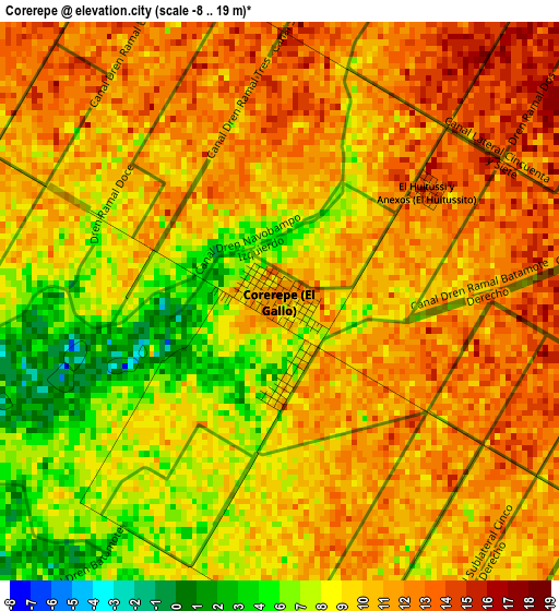
Below is the Elevation map of Corerepe, which displays elevation range with different colors. Scale of the first map is from -8 to 19 m (-26 to 62 ft) with average elevation of 9.6 meters (=31 ft) [note 1]
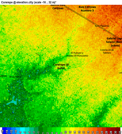
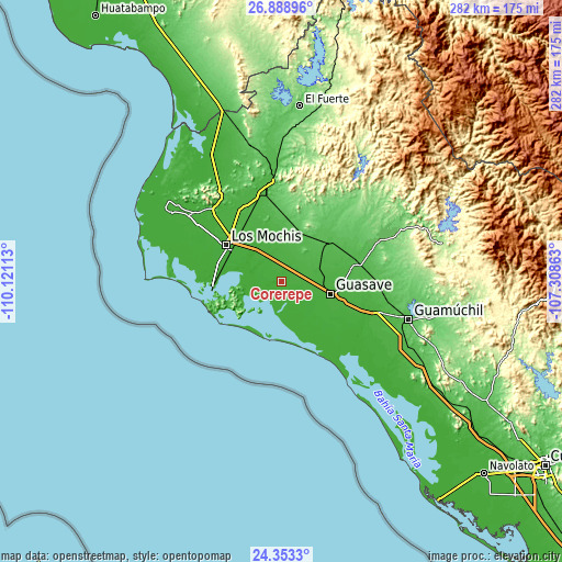
These maps also provides idea of topography and contour of this city, they are displayed at different zoom levels. More info about maps, scale and edge coordinates you can find below images.
| \ | Map #1 | Map #2 | Topo.Map |
| Scale [m] | -8..19 m | -16..32 m | × |
| Scale [ft] | -26..62 ft | -52..105 ft | × |
| Average | 9.6 m = 31 ft | 10.3 m = 34 ft | × |
| Width | 8.81 km = 5.5 mi | 17.62 km = 10.9 mi | 281.9 km = 175.2 mi |
| Height | 8.81 km = 5.5 mi | 17.62 km = 10.9 mi | 282 km = 175.2 mi |
| ↑Max Latitude | 25.667475° | 25.707078° | 26.88896° |
| Latitude at center | 25.62786° | 25.62786° | 25.62786° |
| ↓Min Latitude | 25.588231° | 25.54859° | 24.3533° |
| ← Min Longitude | -108.758825° | -108.802771° | -110.12113° |
| Longitude center | -108.71488° | -108.71488° | -108.71488° |
| →Max Longitude | -108.670935° | -108.626989° | -107.30863° |
Nearby cities:
Cities around Corerepe sort by population:
• Leyva Solano elevation 24 m
8.7 km,  64°
64°
• Juan José Ríos 15 m
18.1 km,  322°
322°
• Adolfo Ruiz Cortines 20 m
8.3 km,  356°
356°
• Adolfo Ruíz Cortínes 19 m
14 km,  345°
345°
• Los Angeles 22 m
23.6 km,  96°
96°
• Bachoco 11 m
12.6 km,  307°
307°
• Gabriel Leyva Velázquez 45 m
23.7 km,  39°
39°
• El Huitusi 7 m
14.6 km,  206°
206°
• Alfonso G. Calderón Velarde 43 m
20.9 km,  32°
32°
• Colonia 24 de Febrero 17 m
6.9 km,  71°
71°
• La Presita 30 m
15.7 km, 55°
• La Noria 31 m
24.1 km, 67°
Multilingual:
 En español:
Corerepe elevación 10 m.
 En France:
Corerepe élévation 10 m.


Sources and notes:
- [note 1] Map square and city borders are not equal. Map elevation data is calculated only from area inside that square.
- [src 1] Elevation data from geonames database provided with same terms of usage.
- [src 2] The elevation map of Corerepe is generated using elevation data from NASA's 3 arcsec (90m) resolution SRTM data.
- [src 3] Base (background) map © OpenStreetMap contributors tiles are generated by Geofabrik and OpenTopoMap.
Copyright & License:
This Corerepe Elevation Map is licensed under CC BY-SA. You may reuse any part from this page, if you give a proper credit by linking to this URL:
 More info on terms of use page.