El Fuerte elevation
El Fuerte (Sinaloa), Mexico elevation is 84 meters and El Fuerte elevation in feet is 276 ft above sea level [src 1]. El Fuerte is a seat of a second-order administrative division (feature code) with elevation that is 1230 meters (4035 ft) smaller than average city elevation in Mexico.
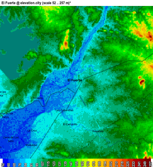
Below is the Elevation map of El Fuerte, which displays elevation range with different colors. Scale of the first map is from 58 to 214 m (190 to 702 ft) with average elevation of 95.8 meters (=314 ft) [note 1]
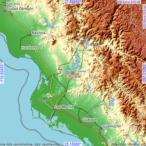
These maps also provides idea of topography and contour of this city, they are displayed at different zoom levels. More info about maps, scale and edge coordinates you can find below images.

| \ | Map #1 | Map #2 | Topo.Map |
| Scale [m] | 58..214 m | 52..257 m | × |
| Scale [ft] | 190..702 ft | 171..843 ft | × |
| Average | 95.8 m = 314 ft | 109.1 m = 358 ft | × |
| Width | 8.75 km = 5.4 mi | 17.5 km = 10.9 mi | 280 km = 174 mi |
| Height | 8.75 km = 5.4 mi | 17.5 km = 10.9 mi | 280.1 km = 174 mi |
| ↑Max Latitude | 26.45621° | 26.495546° | 27.66932° |
| Latitude at center | 26.41686° | 26.41686° | 26.41686° |
| ↓Min Latitude | 26.377497° | 26.33812° | 25.15065° |
| ← Min Longitude | -108.662225° | -108.706171° | -110.02453° |
| Longitude center | -108.61828° | -108.61828° | -108.61828° |
| →Max Longitude | -108.574335° | -108.530389° | -107.21203° |
Nearby cities:
Cities around El Fuerte sort by population:
• Choix elevation 240 m
43.6 km,  41°
41°
• San Blas 38 m
40.1 km,  200°
200°
• Charay 30 m
48.8 km,  205°
205°
• Poblado Número Cinco 11 m
49.2 km,  243°
243°
• Chihuahuita 10 m
52.4 km, 236°
• Lázaro Cárdenas 32 m
44.7 km, 203°
• Agiabampo Uno 5 m
52.8 km,  263°
263°
• Bacorehuis 8 m
47.8 km, 256°
• Agua Caliente Grande (De Gastélum) 272 m
30.1 km,  63°
63°
• Chinobampo 287 m
25.5 km,  96°
96°
• Huepaco 25 m
53.8 km, 206°
• El Pochotal 31 m
52 km, 205°
Multilingual:
 En español:
El Fuerte de Montes Claros elevación 84 m.
 En France:
El Fuerte élévation 84 m.
 Auf Deutsch:
El Fuerte höhe über dem Meeresspiegel ist 84 m.

Sources and notes:
- [note 1] Map square and city borders are not equal. Map elevation data is calculated only from area inside that square.
- [src 1] Elevation data from geonames database provided with same terms of usage.
- [src 2] The elevation map of El Fuerte is generated using elevation data from NASA's 3 arcsec (90m) resolution SRTM data.
- [src 3] Base (background) map © OpenStreetMap contributors tiles are generated by Geofabrik and OpenTopoMap.
Copyright & License:
This El Fuerte Elevation Map is licensed under CC BY-SA. You may reuse any part from this page, if you give a proper credit by linking to this URL:
 More info on terms of use page.