El Lucero elevation
El Lucero (Durango, Tlahualilo), Mexico elevation is 1105 meters and El Lucero elevation in feet is 3625 ft above sea level [src 1]. El Lucero is a populated place (feature code) with elevation that is 209 meters (686 ft) smaller than average city elevation in Mexico.
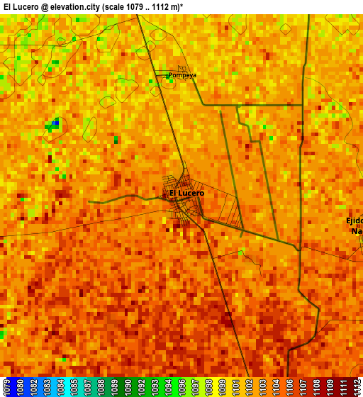
Below is the Elevation map of El Lucero, which displays elevation range with different colors. Scale of the first map is from 1079 to 1112 m (3540 to 3648 ft) with average elevation of 1103 meters (=3619 ft) [note 1]
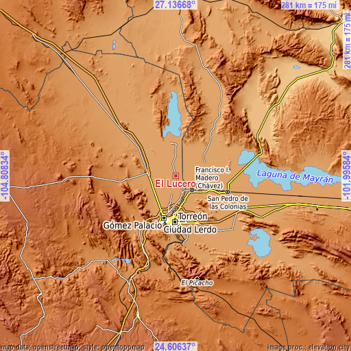
These maps also provides idea of topography and contour of this city, they are displayed at different zoom levels. More info about maps, scale and edge coordinates you can find below images.
| \ | Map #1 | Topo.Map |
| Scale [m] | 1079..1112 m | × |
| Scale [ft] | 3540..3648 ft | × |
| Average | 1103 m = 3619 ft | × |
| Width | 8.79 km = 5.5 mi | 281.3 km = 174.8 mi |
| Height | 8.79 km = 5.5 mi | 281.4 km = 174.9 mi |
| ↑Max Latitude | 25.917832° | 27.13668° |
| Latitude at center | 25.8783° | 25.8783° |
| ↓Min Latitude | 25.838755° | 24.60637° |
| ← Min Longitude | -103.446035° | -104.80834° |
| Longitude center | -103.40209° | -103.40209° |
| →Max Longitude | -103.358145° | -101.99584° |
Nearby cities:
Cities around El Lucero sort by population:
• El Lequeitio elevation 1106 m
12.8 km,  105°
105°
• Venecia 1111 m
12.2 km,  155°
155°
• San Francisco de Horizonte (Horizonte) 1100 m
6.7 km,  347°
347°
• Arcinas 1113 m
11.4 km,  183°
183°
• Jiménez 1106 m
6.9 km,  139°
139°
• Huitrón 1104 m
5.9 km, 113°
• Arturo Martínez Adame 1108 m
5.5 km, 159°
• Eureka de Media Luna (Eureka) 1112 m
9.3 km, 162°
• Jauja 1100 m
6.3 km,  26°
26°
• Banco Nacional 1104 m
4.6 km,  99°
99°
• San Julio 1099 m
6.7 km,  343°
343°
• California 1112 m
13.3 km,  168°
168°
Multilingual:
 En español:
El Lucero elevación 1105 m.
 En France:
El Lucero élévation 1105 m.
 Auf Deutsch:
El Lucero höhe über dem Meeresspiegel ist 1105 m.

Sources and notes:
- [note 1] Map square and city borders are not equal. Map elevation data is calculated only from area inside that square.
- [src 1] Elevation data from geonames database provided with same terms of usage.
- [src 2] The elevation map of El Lucero is generated using elevation data from NASA's 3 arcsec (90m) resolution SRTM data.
- [src 3] Base (background) map © OpenStreetMap contributors tiles are generated by Geofabrik and OpenTopoMap.
Copyright & License:
This El Lucero Elevation Map is licensed under CC BY-SA. You may reuse any part from this page, if you give a proper credit by linking to this URL:
 More info on terms of use page.