El Molino elevation
El Molino (Chihuahua, Rosales), Mexico elevation is 1185 meters and El Molino elevation in feet is 3888 ft above sea level [src 1]. El Molino is a populated place (feature code) with elevation that is 129 meters (423 ft) smaller than average city elevation in Mexico.
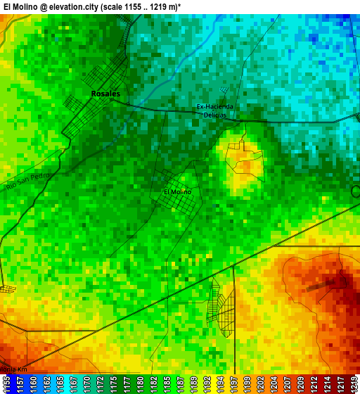
Below is the Elevation map of El Molino, which displays elevation range with different colors. Scale of the first map is from 1155 to 1219 m (3789 to 3999 ft) with average elevation of 1183.4 meters (=3883 ft) [note 1]
These maps also provides idea of topography and contour of this city, they are displayed at different zoom levels. More info about maps, scale and edge coordinates you can find below images.
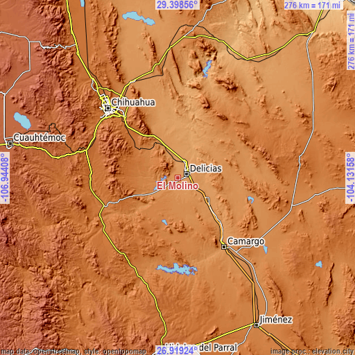
| \ | Map #1 | Topo.Map |
| Scale [m] | 1155..1219 m | × |
| Scale [ft] | 3789..3999 ft | × |
| Average | 1183.4 m = 3883 ft | × |
| Width | 8.62 km = 5.4 mi | 275.7 km = 171.3 mi |
| Height | 8.62 km = 5.4 mi | 275.7 km = 171.3 mi |
| ↑Max Latitude | 28.204814° | 29.39856° |
| Latitude at center | 28.16608° | 28.16608° |
| ↓Min Latitude | 28.127332° | 26.91924° |
| ← Min Longitude | -105.581775° | -106.94408° |
| Longitude center | -105.53783° | -105.53783° |
| →Max Longitude | -105.493885° | -104.13158° |
Nearby cities:
Cities around El Molino sort by population:
• Ciudad Delicias elevation 1172 m
7.2 km,  68°
68°
• Meoqui 1147 m
13.1 km,  25°
25°
• Rosales 1182 m
3 km,  321°
321°
• Colonia Revolución 1182 m
12.5 km,  47°
47°
• Miguel Hidalgo 1215 m
14.2 km,  95°
95°
• Congregación Ortíz 1150 m
9.9 km,  10°
10°
• Colonia Campesina 1193 m
3.1 km,  159°
159°
• Estación Consuelo 1191 m
19.2 km,  343°
343°
• Colonia Nicolás Bravo (Kilómetro Noventa y Dos) 1212 m
8.3 km,  173°
173°
• Colonia Terrazas 1158 m
10.7 km,  41°
41°
• Colonia Abraham González (La Quemada) 1210 m
13.5 km, 70°
• Kilómetro Noventa y Nueve 1213 m
6 km,  223°
223°
Multilingual:
 En español:
El Molino elevación 1185 m.
 En France:
El Molino élévation 1185 m.
 Auf Deutsch:
El Molino höhe über dem Meeresspiegel ist 1185 m.

Sources and notes:
- [note 1] Map square and city borders are not equal. Map elevation data is calculated only from area inside that square.
- [src 1] Elevation data from geonames database provided with same terms of usage.
- [src 2] The elevation map of El Molino is generated using elevation data from NASA's 3 arcsec (90m) resolution SRTM data.
- [src 3] Base (background) map © OpenStreetMap contributors tiles are generated by Geofabrik and OpenTopoMap.
Copyright & License:
This El Molino Elevation Map is licensed under CC BY-SA. You may reuse any part from this page, if you give a proper credit by linking to this URL:
 More info on terms of use page.