Guamúchil elevation
Guamúchil (Sinaloa, Salvador Alvarado), Mexico elevation is 46 meters and Guamúchil elevation in feet is 151 ft above sea level [src 1]. Guamúchil is a populated place (feature code) with elevation that is 1268 meters (4160 ft) smaller than average city elevation in Mexico.
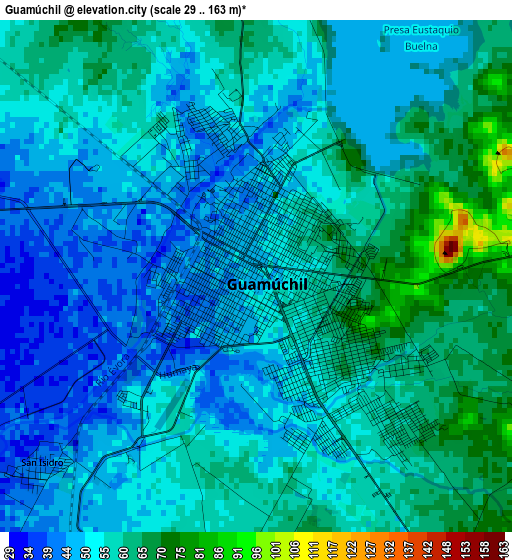
Below is the Elevation map of Guamúchil, which displays elevation range with different colors. Scale of the first map is from 29 to 163 m (95 to 535 ft) with average elevation of 54.8 meters (=180 ft) [note 1]
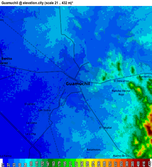
These maps also provides idea of topography and contour of this city, they are displayed at different zoom levels. More info about maps, scale and edge coordinates you can find below images.
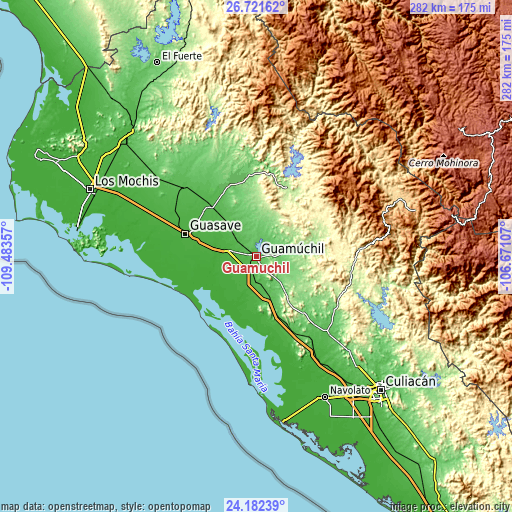
| \ | Map #1 | Map #2 | Topo.Map |
| Scale [m] | 29..163 m | 21..432 m | × |
| Scale [ft] | 95..535 ft | 69..1417 ft | × |
| Average | 54.8 m = 180 ft | 65.1 m = 214 ft | × |
| Width | 8.82 km = 5.5 mi | 17.65 km = 11 mi | 282.3 km = 175.4 mi |
| Height | 8.82 km = 5.5 mi | 17.65 km = 11 mi | 282.3 km = 175.4 mi |
| ↑Max Latitude | 25.498371° | 25.53803° | 26.72162° |
| Latitude at center | 25.4587° | 25.4587° | 25.4587° |
| ↓Min Latitude | 25.419015° | 25.379318° | 24.18239° |
| ← Min Longitude | -108.121265° | -108.165211° | -109.48357° |
| Longitude center | -108.07732° | -108.07732° | -108.07732° |
| →Max Longitude | -108.033375° | -107.989429° | -106.67107° |
Nearby cities:
Cities around Guamúchil sort by population:
• Mocorito elevation 86 m
16 km,  80°
80°
• Angostura 28 m
13.3 km,  219°
219°
• Alhuey 26 m
10.4 km,  210°
210°
• Las Brisas 20 m
17.3 km,  281°
281°
• La Esperanza 21 m
16.4 km, 221°
• San Rafael 17 m
23.2 km, 279°
• Alfredo V. Bonfil (Siete Ejidos) 54 m
25.8 km,  322°
322°
• Estación Capomas 44 m
21.5 km, 317°
• Higuera de los Vega 181 m
24.9 km,  28°
28°
• Gustavo Díaz Ordaz 28 m
21.4 km,  184°
184°
• La Palma 27 m
11.8 km, 224°
• Cerro Agudo 134 m
19.3 km,  36°
36°
Multilingual:
 En español:
Guamúchil elevación 46 m.
 En France:
Guamúchil élévation 46 m.
 Auf Deutsch:
Guamúchil höhe über dem Meeresspiegel ist 46 m.

Sources and notes:
- [note 1] Map square and city borders are not equal. Map elevation data is calculated only from area inside that square.
- [src 1] Elevation data from geonames database provided with same terms of usage.
- [src 2] The elevation map of Guamúchil is generated using elevation data from NASA's 3 arcsec (90m) resolution SRTM data.
- [src 3] Base (background) map © OpenStreetMap contributors tiles are generated by Geofabrik and OpenTopoMap.
Copyright & License:
This Guamúchil Elevation Map is licensed under CC BY-SA. You may reuse any part from this page, if you give a proper credit by linking to this URL:
 More info on terms of use page.