Guanajuato elevation
Guanajuato, Mexico elevation is 2010 meters and Guanajuato elevation in feet is 6594 ft above sea level [src 1]. Guanajuato is a seat of a first-order administrative division (feature code) with elevation that is 696 meters (2283 ft) bigger than average city elevation in Mexico.
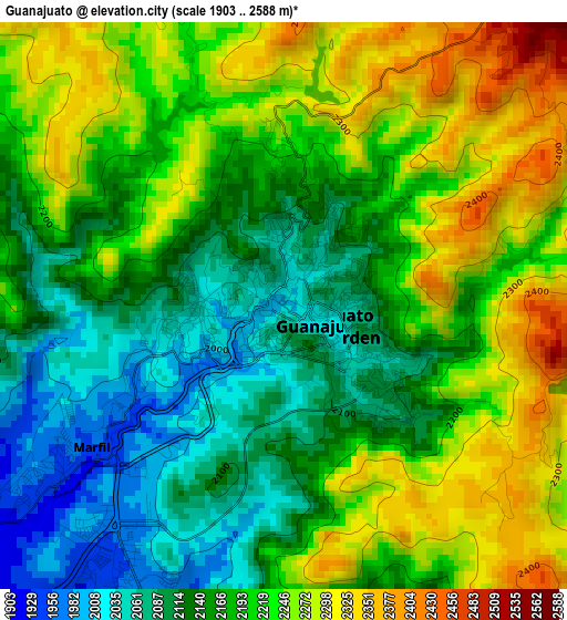
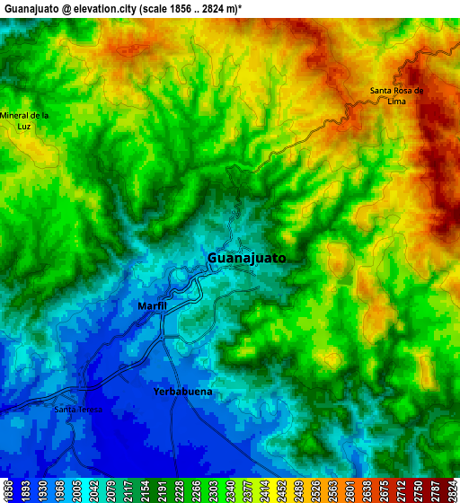
Below is the Elevation map of Guanajuato, which displays elevation range with different colors. Scale of the first map is from 1903 to 2588 m (6243 to 8491 ft) with average elevation of 2188.9 meters (=7181 ft) [note 1]
These maps also provides idea of topography and contour of this city, they are displayed at different zoom levels. More info about maps, scale and edge coordinates you can find below images.
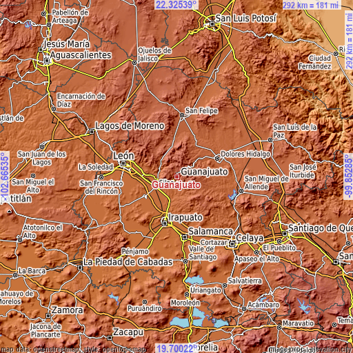
| \ | Map #1 | Map #2 | Topo.Map |
| Scale [m] | 1903..2588 m | 1856..2824 m | × |
| Scale [ft] | 6243..8491 ft | 6089..9265 ft | × |
| Average | 2188.9 m = 7181 ft | 2241.3 m = 7353 ft | × |
| Width | 9.12 km = 5.7 mi | 18.24 km = 11.3 mi | 291.9 km = 181.4 mi |
| Height | 9.12 km = 5.7 mi | 18.24 km = 11.3 mi | 291.9 km = 181.4 mi |
| ↑Max Latitude | 21.059596° | 21.1006° | 22.32539° |
| Latitude at center | 21.01858° | 21.01858° | 21.01858° |
| ↓Min Latitude | 20.977553° | 20.936515° | 19.70022° |
| ← Min Longitude | -101.303045° | -101.346991° | -102.66535° |
| Longitude center | -101.2591° | -101.2591° | -101.2591° |
| →Max Longitude | -101.215155° | -101.171209° | -99.85285° |
Nearby cities:
Cities around Guanajuato sort by population:
• Marfil elevation 1974 m
4 km,  221°
221°
• Yerbabuena 1939 m
6.4 km,  194°
194°
• Santa Teresa 1898 m
8.8 km, 222°
• Puentecillas 1867 m
9.9 km, 191°
• San José de Cervera 1897 m
7.2 km, 218°
• Los Lorenzos 1975 m
13.5 km,  296°
296°
• Paso de Pirules 1876 m
8.7 km,  209°
209°
• Fraccionamiento Villas de Guanajuato 1895 m
7.6 km, 211°
• San José del Rodeo 1928 m
11.7 km,  157°
157°
• Santa Rosa de Lima 2550 m
8.7 km,  47°
47°
• Mineral de la Luz 2402 m
9.7 km, 301°
• Aguas Buenas 1856 m
12.9 km,  245°
245°
Multilingual:
 En español:
Guanajuato elevación 2010 m.
 En France:
Guanajuato élévation 2010 m.
 Auf Deutsch:
Guanajuato höhe über dem Meeresspiegel ist 2010 m.

Sources and notes:
- [note 1] Map square and city borders are not equal. Map elevation data is calculated only from area inside that square.
- [src 1] Elevation data from geonames database provided with same terms of usage.
- [src 2] The elevation map of Guanajuato is generated using elevation data from NASA's 3 arcsec (90m) resolution SRTM data.
- [src 3] Base (background) map © OpenStreetMap contributors tiles are generated by Geofabrik and OpenTopoMap.
Copyright & License:
This Guanajuato Elevation Map is licensed under CC BY-SA. You may reuse any part from this page, if you give a proper credit by linking to this URL:
 More info on terms of use page.