Hidalgo elevation
Hidalgo (Coahuila, Francisco I. Madero), Mexico elevation is 1106 meters and Hidalgo elevation in feet is 3629 ft above sea level [src 1]. Hidalgo is a populated place (feature code) with elevation that is 208 meters (682 ft) smaller than average city elevation in Mexico.
Below is the Elevation map of Hidalgo, which displays elevation range with different colors. Scale of the first map is from 1097 to 1116 m (3599 to 3661 ft) with average elevation of 1107.3 meters (=3633 ft) [note 1]
These maps also provides idea of topography and contour of this city, they are displayed at different zoom levels. More info about maps, scale and edge coordinates you can find below images.
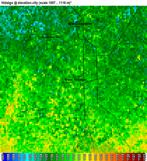
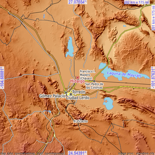
| \ | Map #1 | Topo.Map |
| Scale [m] | 1097..1116 m | × |
| Scale [ft] | 3599..3661 ft | × |
| Average | 1107.3 m = 3633 ft | × |
| Width | 8.8 km = 5.5 mi | 281.5 km = 174.9 mi |
| Height | 8.8 km = 5.5 mi | 281.5 km = 174.9 mi |
| ↑Max Latitude | 25.856043° | 27.07554° |
| Latitude at center | 25.81649° | 25.81649° |
| ↓Min Latitude | 25.776924° | 24.54391° |
| ← Min Longitude | -103.326505° | -104.68881° |
| Longitude center | -103.28256° | -103.28256° |
| →Max Longitude | -103.238615° | -101.87631° |
Nearby cities:
Cities around Hidalgo sort by population:
• Francisco I. Madero elevation 1112 m
5 km,  166°
166°
• Seis de Octubre (Santo Niño) 1114 m
7.3 km,  143°
143°
• El Lequeitio 1106 m
3.4 km,  6°
6°
• Venecia 1111 m
8.2 km,  238°
238°
• La Florida 1113 m
6.8 km,  217°
217°
• El Porvenir (El Porvenir de Arriba) 1111 m
6.3 km, 222°
• Jiménez 1106 m
7.6 km,  281°
281°
• Huitrón 1104 m
8 km,  304°
304°
• Virginias 1108 m
2 km,  149°
149°
• La Fe 1107 m
8.8 km,  67°
67°
• Jaboncillo 1114 m
7.8 km, 167°
• Compuertas 1114 m
8 km,  194°
194°
Multilingual:
 En español:
Hidalgo elevación 1106 m.
 En France:
Hidalgo élévation 1106 m.
 Auf Deutsch:
Hidalgo höhe über dem Meeresspiegel ist 1106 m.

Sources and notes:
- [note 1] Map square and city borders are not equal. Map elevation data is calculated only from area inside that square.
- [src 1] Elevation data from geonames database provided with same terms of usage.
- [src 2] The elevation map of Hidalgo is generated using elevation data from NASA's 3 arcsec (90m) resolution SRTM data.
- [src 3] Base (background) map © OpenStreetMap contributors tiles are generated by Geofabrik and OpenTopoMap.
Copyright & License:
This Hidalgo Elevation Map is licensed under CC BY-SA. You may reuse any part from this page, if you give a proper credit by linking to this URL:
 More info on terms of use page.