Ixtapa elevation
Ixtapa (Jalisco, Puerto Vallarta), Mexico elevation is 26 meters and Ixtapa elevation in feet is 85 ft above sea level [src 1]. Ixtapa is a populated place (feature code) with elevation that is 1288 meters (4226 ft) smaller than average city elevation in Mexico.
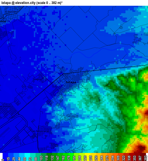
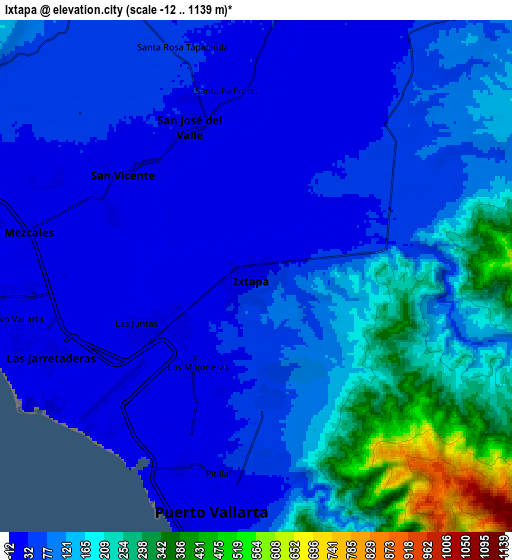
Below is the Elevation map of Ixtapa, which displays elevation range with different colors. Scale of the first map is from 0 to 382 m (0 to 1253 ft) with average elevation of 46 meters (=151 ft) [note 1]
These maps also provides idea of topography and contour of this city, they are displayed at different zoom levels. More info about maps, scale and edge coordinates you can find below images.
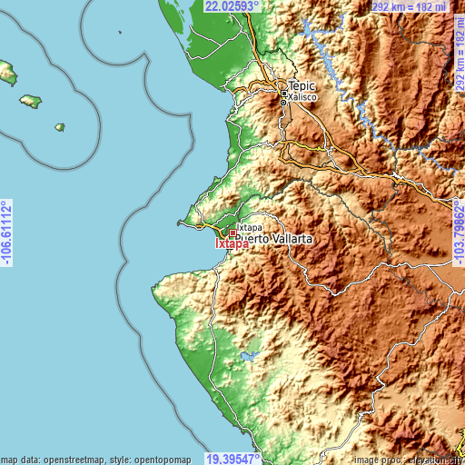
| \ | Map #1 | Map #2 | Topo.Map |
| Scale [m] | 0..382 m | -12..1139 m | × |
| Scale [ft] | 0..1253 ft | -39..3737 ft | × |
| Average | 46 m = 151 ft | 111.9 m = 367 ft | × |
| Width | 9.14 km = 5.7 mi | 18.28 km = 11.4 mi | 292.5 km = 181.8 mi |
| Height | 9.14 km = 5.7 mi | 18.28 km = 11.4 mi | 292.5 km = 181.8 mi |
| ↑Max Latitude | 20.757508° | 20.798596° | 22.02593° |
| Latitude at center | 20.71641° | 20.71641° | 20.71641° |
| ↓Min Latitude | 20.6753° | 20.63418° | 19.39547° |
| ← Min Longitude | -105.248815° | -105.292761° | -106.61112° |
| Longitude center | -105.20487° | -105.20487° | -105.20487° |
| →Max Longitude | -105.160925° | -105.116979° | -103.79862° |
Nearby cities:
Cities around Ixtapa sort by population:
• San José del Valle elevation 24 m
5.8 km,  335°
335°
• Mezcales 18 m
8.2 km,  281°
281°
• San Vicente 18 m
5.9 km,  307°
307°
• San Juan de Abajo 37 m
11 km,  7°
7°
• Las Juntas 11 m
4.6 km,  248°
248°
• Las Jarretaderas 8 m
7.7 km, 249°
• El Porvenir 23 m
5.7 km,  317°
317°
• Banus Vallarta (Verde Vallarta) 15 m
1.9 km,  268°
268°
• Nuevo Vallarta 8 m
9.4 km,  260°
260°
• El Ranchito 47 m
6.1 km,  71°
71°
• El Colorado 39 m
7.8 km,  40°
40°
• San Clemente de Lima 13 m
7.2 km,  288°
288°
Multilingual:
 En español:
Ixtapa elevación 26 m.
 En France:
Ixtapa élévation 26 m.


Sources and notes:
- [note 1] Map square and city borders are not equal. Map elevation data is calculated only from area inside that square.
- [src 1] Elevation data from geonames database provided with same terms of usage.
- [src 2] The elevation map of Ixtapa is generated using elevation data from NASA's 3 arcsec (90m) resolution SRTM data.
- [src 3] Base (background) map © OpenStreetMap contributors tiles are generated by Geofabrik and OpenTopoMap.
Copyright & License:
This Ixtapa Elevation Map is licensed under CC BY-SA. You may reuse any part from this page, if you give a proper credit by linking to this URL:
 More info on terms of use page.