La Huacana elevation
La Huacana (Michoacán), Mexico elevation is 489 meters and La Huacana elevation in feet is 1604 ft above sea level [src 1]. La Huacana is a seat of a second-order administrative division (feature code) with elevation that is 825 meters (2707 ft) smaller than average city elevation in Mexico.
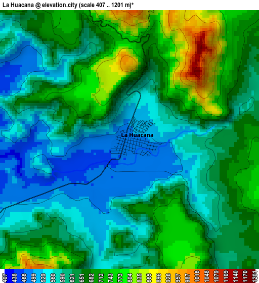
Below is the Elevation map of La Huacana, which displays elevation range with different colors. Scale of the first map is from 407 to 1201 m (1335 to 3940 ft) with average elevation of 641.9 meters (=2106 ft) [note 1]
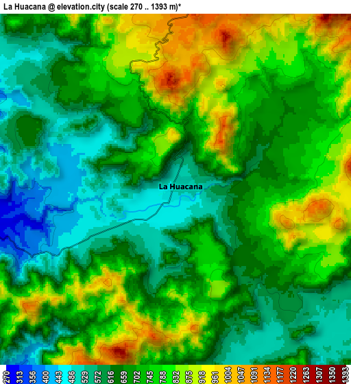
These maps also provides idea of topography and contour of this city, they are displayed at different zoom levels. More info about maps, scale and edge coordinates you can find below images.
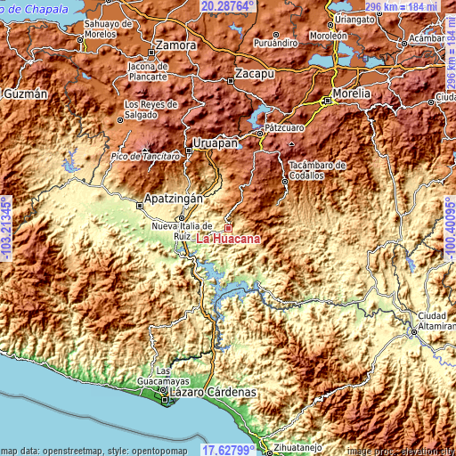
| \ | Map #1 | Map #2 | Topo.Map |
| Scale [m] | 407..1201 m | 270..1393 m | × |
| Scale [ft] | 1335..3940 ft | 886..4570 ft | × |
| Average | 641.9 m = 2106 ft | 707.7 m = 2322 ft | × |
| Width | 9.24 km = 5.7 mi | 18.48 km = 11.5 mi | 295.7 km = 183.7 mi |
| Height | 9.24 km = 5.7 mi | 18.48 km = 11.5 mi | 295.7 km = 183.7 mi |
| ↑Max Latitude | 19.004675° | 19.04622° | 20.28764° |
| Latitude at center | 18.96312° | 18.96312° | 18.96312° |
| ↓Min Latitude | 18.921555° | 18.879979° | 17.62799° |
| ← Min Longitude | -101.851145° | -101.895091° | -103.21345° |
| Longitude center | -101.8072° | -101.8072° | -101.8072° |
| →Max Longitude | -101.763255° | -101.719309° | -100.40095° |
Nearby cities:
Cities around La Huacana sort by population:
• Nueva Italia de Ruiz elevation 416 m
30.8 km,  282°
282°
• Ario de Rosales 1916 m
29.3 km,  20°
20°
• Zicuirán 202 m
19.4 km,  240°
240°
• El Chauz 232 m
25.7 km,  252°
252°
• El Cahulote de Santa Ana 1410 m
26.8 km,  61°
61°
• Nuevo Urecho 765 m
23.5 km,  344°
344°
• Santa Casilda 452 m
26.1 km,  323°
323°
• La Ibérica (La Gotera) 463 m
25.2 km,  332°
332°
• Poturo 535 m
25.5 km,  126°
126°
• El Guaco 458 m
28.8 km,  293°
293°
• Tavera 1270 m
28.3 km,  67°
67°
• Los Cajones 501 m
29.6 km, 337°
Multilingual:
 En español:
La Huacana elevación 489 m.
 En France:
La Huacana élévation 489 m.
 Auf Deutsch:
La Huacana höhe über dem Meeresspiegel ist 489 m.

Sources and notes:
- [note 1] Map square and city borders are not equal. Map elevation data is calculated only from area inside that square.
- [src 1] Elevation data from geonames database provided with same terms of usage.
- [src 2] The elevation map of La Huacana is generated using elevation data from NASA's 3 arcsec (90m) resolution SRTM data.
- [src 3] Base (background) map © OpenStreetMap contributors tiles are generated by Geofabrik and OpenTopoMap.
Copyright & License:
This La Huacana Elevation Map is licensed under CC BY-SA. You may reuse any part from this page, if you give a proper credit by linking to this URL:
 More info on terms of use page.