La Paz elevation
La Paz (Baja California Sur), Mexico elevation is 47 meters and La Paz elevation in feet is 154 ft above sea level [src 1]. La Paz is a seat of a first-order administrative division (feature code) with elevation that is 1267 meters (4157 ft) smaller than average city elevation in Mexico.
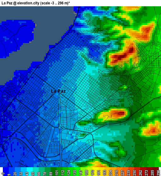
Below is the Elevation map of La Paz, which displays elevation range with different colors. Scale of the first map is from -3 to 296 m (-10 to 971 ft) with average elevation of 65.3 meters (=214 ft) [note 1]
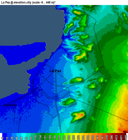
These maps also provides idea of topography and contour of this city, they are displayed at different zoom levels. More info about maps, scale and edge coordinates you can find below images.
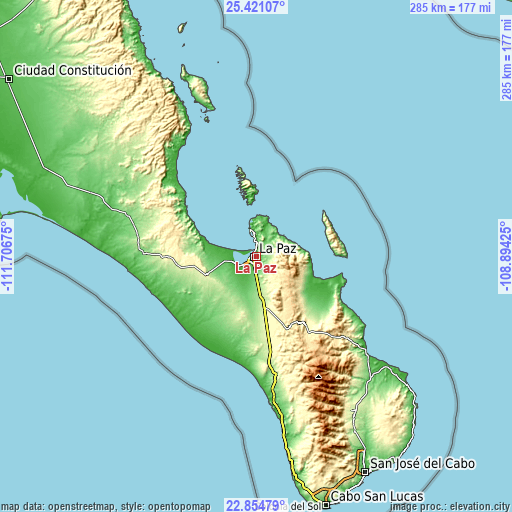
| \ | Map #1 | Map #2 | Topo.Map |
| Scale [m] | -3..296 m | -6..448 m | × |
| Scale [ft] | -10..971 ft | -20..1470 ft | × |
| Average | 65.3 m = 214 ft | 98.9 m = 324 ft | × |
| Width | 8.92 km = 5.5 mi | 17.84 km = 11.1 mi | 285.3 km = 177.3 mi |
| Height | 8.92 km = 5.5 mi | 17.84 km = 11.1 mi | 285.4 km = 177.3 mi |
| ↑Max Latitude | 24.184465° | 24.224547° | 25.42107° |
| Latitude at center | 24.14437° | 24.14437° | 24.14437° |
| ↓Min Latitude | 24.104263° | 24.064143° | 22.85479° |
| ← Min Longitude | -110.344445° | -110.388391° | -111.70675° |
| Longitude center | -110.3005° | -110.3005° | -110.3005° |
| →Max Longitude | -110.256555° | -110.212609° | -108.89425° |
Nearby cities:
Cities around La Paz sort by population:
• San José del Cabo elevation 16 m
135.4 km,  153°
153°
• Las Palmas 150 m
139.2 km,  164°
164°
• Las Veredas 79 m
126 km, 151°
• Todos Santos 38 m
78 km,  174°
174°
• El Centenario 8 m
12.5 km,  248°
248°
• El Pescadero 53 m
87.8 km, 171°
• Chametla 8 m
9 km,  236°
236°
• La Rivera 27 m
95 km,  130°
130°
• Melitón Albáñez Domínguez 35 m
55.1 km,  192°
192°
• La Playa 22 m
136.3 km, 151°
• Miraflores 241 m
101.4 km, 148°
• Los Barriles 14 m
79.8 km, 130°
Multilingual:
 En español:
La Paz elevación 47 m.
 En France:
La Paz élévation 47 m.


Sources and notes:
- [note 1] Map square and city borders are not equal. Map elevation data is calculated only from area inside that square.
- [src 1] Elevation data from geonames database provided with same terms of usage.
- [src 2] The elevation map of La Paz is generated using elevation data from NASA's 3 arcsec (90m) resolution SRTM data.
- [src 3] Base (background) map © OpenStreetMap contributors tiles are generated by Geofabrik and OpenTopoMap.
Copyright & License:
This La Paz Elevation Map is licensed under CC BY-SA. You may reuse any part from this page, if you give a proper credit by linking to this URL:
 More info on terms of use page.