Lombardía elevation
Lombardía (Michoacán, Gabriel Zamora), Mexico elevation is 654 meters and Lombardía elevation in feet is 2146 ft above sea level [src 1]. Lombardía is a populated place (feature code) with elevation that is 660 meters (2165 ft) smaller than average city elevation in Mexico.
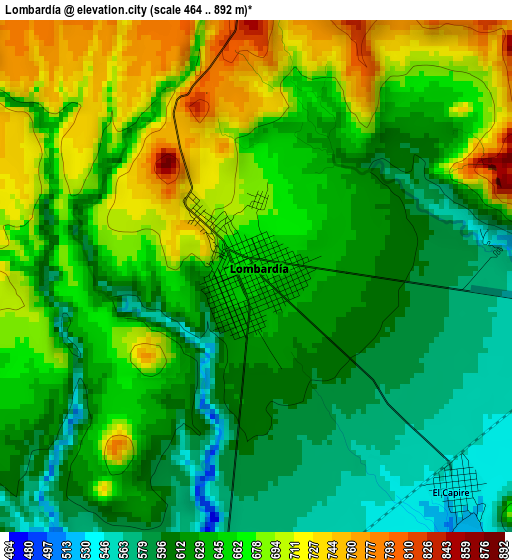
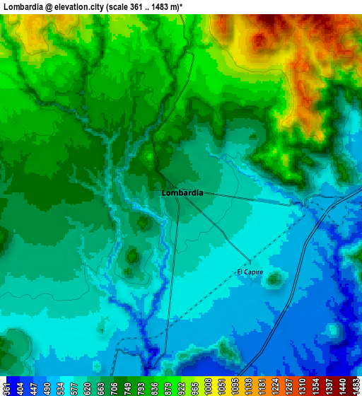
Below is the Elevation map of Lombardía, which displays elevation range with different colors. Scale of the first map is from 464 to 892 m (1522 to 2927 ft) with average elevation of 645.3 meters (=2117 ft) [note 1]
These maps also provides idea of topography and contour of this city, they are displayed at different zoom levels. More info about maps, scale and edge coordinates you can find below images.
| \ | Map #1 | Map #2 | Topo.Map |
| Scale [m] | 464..892 m | 361..1483 m | × |
| Scale [ft] | 1522..2927 ft | 1184..4865 ft | × |
| Average | 645.3 m = 2117 ft | 696 m = 2283 ft | × |
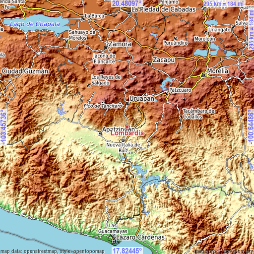
| Width | 9.23 km = 5.7 mi | 18.46 km = 11.5 mi | 295.4 km = 183.6 mi |
| Height | 9.23 km = 5.7 mi | 18.46 km = 11.5 mi | 295.4 km = 183.6 mi |
| ↑Max Latitude | 19.199566° | 19.241062° | 20.48097° |
| Latitude at center | 19.15806° | 19.15806° | 19.15806° |
| ↓Min Latitude | 19.116543° | 19.075016° | 17.82445° |
| ← Min Longitude | -102.095055° | -102.139001° | -103.45736° |
| Longitude center | -102.05111° | -102.05111° | -102.05111° |
| →Max Longitude | -102.007165° | -101.963219° | -100.64486° |
Nearby cities:
Cities around Lombardía sort by population:
• Nueva Italia de Ruiz elevation 416 m
15.4 km,  196°
196°
• Paracuaro 610 m
17.6 km,  266°
266°
• El Ceñidor 357 m
22.6 km,  220°
220°
• El Letrero 314 m
22.5 km, 196°
• Buenos Aires 481 m
16.4 km,  235°
235°
• Nuevo Urecho 765 m
19.2 km,  87°
87°
• Santa Casilda 452 m
10.2 km, 93°
• La Ibérica (La Gotera) 463 m
14.2 km, 87°
• Cuatro Caminos 358 m
19.7 km, 196°
• El Guaco 458 m
10.1 km,  183°
183°
• Charapendo 1011 m
11.9 km,  352°
352°
• Los Cajones 501 m
15.6 km,  68°
68°
Multilingual:
 En español:
Lombardía elevación 654 m.
 En France:
Lombardía élévation 654 m.
 Auf Deutsch:
Lombardía höhe über dem Meeresspiegel ist 654 m.

Sources and notes:
- [note 1] Map square and city borders are not equal. Map elevation data is calculated only from area inside that square.
- [src 1] Elevation data from geonames database provided with same terms of usage.
- [src 2] The elevation map of Lombardía is generated using elevation data from NASA's 3 arcsec (90m) resolution SRTM data.
- [src 3] Base (background) map © OpenStreetMap contributors tiles are generated by Geofabrik and OpenTopoMap.
Copyright & License:
This Lombardía Elevation Map is licensed under CC BY-SA. You may reuse any part from this page, if you give a proper credit by linking to this URL:
 More info on terms of use page.