Manzanillo elevation
Manzanillo (Colima), Mexico elevation is 12 meters and Manzanillo elevation in feet is 39 ft above sea level [src 1]. Manzanillo is a seat of a second-order administrative division (feature code) with elevation that is 1302 meters (4272 ft) smaller than average city elevation in Mexico.
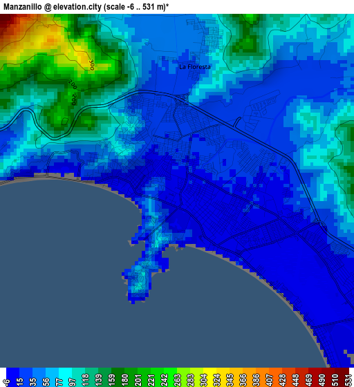
Below is the Elevation map of Manzanillo, which displays elevation range with different colors. Scale of the first map is from -6 to 531 m (-20 to 1742 ft) with average elevation of 68.4 meters (=224 ft) [note 1]
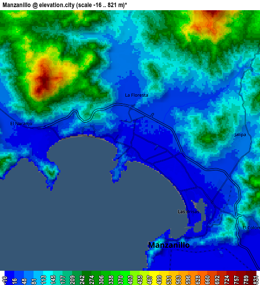
These maps also provides idea of topography and contour of this city, they are displayed at different zoom levels. More info about maps, scale and edge coordinates you can find below images.
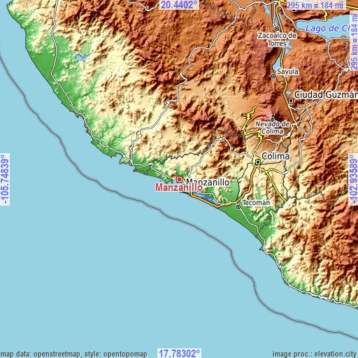
| \ | Map #1 | Map #2 | Topo.Map |
| Scale [m] | -6..531 m | -16..821 m | × |
| Scale [ft] | -20..1742 ft | -52..2694 ft | × |
| Average | 68.4 m = 224 ft | 151.3 m = 496 ft | × |
| Width | 9.23 km = 5.7 mi | 18.47 km = 11.5 mi | 295.5 km = 183.6 mi |
| Height | 9.23 km = 5.7 mi | 18.47 km = 11.5 mi | 295.5 km = 183.6 mi |
| ↑Max Latitude | 19.158467° | 19.199973° | 20.4402° |
| Latitude at center | 19.11695° | 19.11695° | 19.11695° |
| ↓Min Latitude | 19.075423° | 19.033886° | 17.78302° |
| ← Min Longitude | -104.386085° | -104.430031° | -105.74839° |
| Longitude center | -104.34214° | -104.34214° | -104.34214° |
| →Max Longitude | -104.298195° | -104.254249° | -102.93589° |
Nearby cities:
Cities around Manzanillo sort by population:
• Cihuatlán elevation 29 m
26.9 km,  299°
299°
• El Colomo 18 m
10.8 km,  125°
125°
• Barra de Navidad 8 m
37.1 km,  285°
285°
• Jalipa 81 m
7.9 km,  85°
85°
• Tequesquitlán 484 m
35.4 km,  328°
328°
• Camotlán de Miraflores 367 m
16.1 km,  44°
44°
• Venustiano Carranza 17 m
27.1 km,  115°
115°
• El Naranjo 30 m
8.1 km,  280°
280°
• La Central 49 m
10.5 km, 285°
• Chacala 414 m
24.2 km,  14°
14°
• Cuyutlán 8 m
36.2 km, 127°
• Tapeixtles 14 m
8.1 km, 130°
Multilingual:
 En español:
Manzanillo elevación 12 m.
 En France:
Manzanillo élévation 12 m.
 Auf Deutsch:
Manzanillo höhe über dem Meeresspiegel ist 12 m.

Sources and notes:
- [note 1] Map square and city borders are not equal. Map elevation data is calculated only from area inside that square.
- [src 1] Elevation data from geonames database provided with same terms of usage.
- [src 2] The elevation map of Manzanillo is generated using elevation data from NASA's 3 arcsec (90m) resolution SRTM data.
- [src 3] Base (background) map © OpenStreetMap contributors tiles are generated by Geofabrik and OpenTopoMap.
Copyright & License:
This Manzanillo Elevation Map is licensed under CC BY-SA. You may reuse any part from this page, if you give a proper credit by linking to this URL:
 More info on terms of use page.