Maripa elevation
Maripa (Sinaloa), Mexico elevation is 82 meters and Maripa elevation in feet is 269 ft above sea level [src 1]. Maripa is a populated place (feature code) with elevation that is 1232 meters (4042 ft) smaller than average city elevation in Mexico.
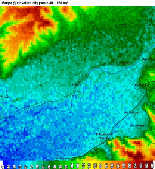
Below is the Elevation map of Maripa, which displays elevation range with different colors. Scale of the first map is from 49 to 168 m (161 to 551 ft) with average elevation of 84.7 meters (=278 ft) [note 1]
These maps also provides idea of topography and contour of this city, they are displayed at different zoom levels. More info about maps, scale and edge coordinates you can find below images.
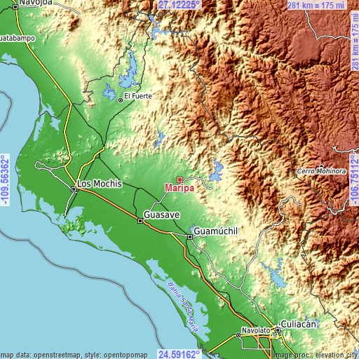
| \ | Map #1 | Topo.Map |
| Scale [m] | 49..168 m | × |
| Scale [ft] | 161..551 ft | × |
| Average | 84.7 m = 278 ft | × |
| Width | 8.79 km = 5.5 mi | 281.4 km = 174.9 mi |
| Height | 8.79 km = 5.5 mi | 281.4 km = 174.9 mi |
| ↑Max Latitude | 25.903247° | 27.12225° |
| Latitude at center | 25.86371° | 25.86371° |
| ↓Min Latitude | 25.82416° | 24.59162° |
| ← Min Longitude | -108.201315° | -109.56362° |
| Longitude center | -108.15737° | -108.15737° |
| →Max Longitude | -108.113425° | -106.75112° |
Nearby cities:
Cities around Maripa sort by population:
• Estacion Bamoa elevation 44 m
23.3 km,  222°
222°
• Sinaloa de Leyva 69 m
8 km,  234°
234°
• Genaro Estrada 97 m
25.2 km,  288°
288°
• Bamoa 41 m
25.8 km, 227°
• Cubiri de Portelas 50 m
13.3 km, 230°
• Portugués de Gálvez 37 m
28.2 km,  237°
237°
• Llano Grande 148 m
14.3 km,  150°
150°
• Baburia 60 m
5.1 km, 242°
• Orba (Infiernito) 35 m
28.3 km, 226°
• Alfredo V. Bonfil (Siete Ejidos) 54 m
25.7 km,  197°
197°
• Estación Capomas 44 m
30 km,  192°
192°
• Bacubirito 174 m
25 km,  103°
103°
Multilingual:
 En español:
Maripa elevación 82 m.
 En France:
Maripa élévation 82 m.


Sources and notes:
- [note 1] Map square and city borders are not equal. Map elevation data is calculated only from area inside that square.
- [src 1] Elevation data from geonames database provided with same terms of usage.
- [src 2] The elevation map of Maripa is generated using elevation data from NASA's 3 arcsec (90m) resolution SRTM data.
- [src 3] Base (background) map © OpenStreetMap contributors tiles are generated by Geofabrik and OpenTopoMap.
Copyright & License:
This Maripa Elevation Map is licensed under CC BY-SA. You may reuse any part from this page, if you give a proper credit by linking to this URL:
 More info on terms of use page.