Mazatán elevation
Mazatán (Sonora), Mexico elevation is 547 meters and Mazatán elevation in feet is 1795 ft above sea level [src 1]. Mazatán is a seat of a second-order administrative division (feature code) with elevation that is 767 meters (2516 ft) smaller than average city elevation in Mexico.
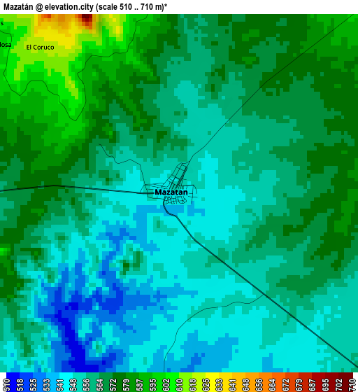
Below is the Elevation map of Mazatán, which displays elevation range with different colors. Scale of the first map is from 510 to 710 m (1673 to 2329 ft) with average elevation of 562.8 meters (=1846 ft) [note 1]
These maps also provides idea of topography and contour of this city, they are displayed at different zoom levels. More info about maps, scale and edge coordinates you can find below images.
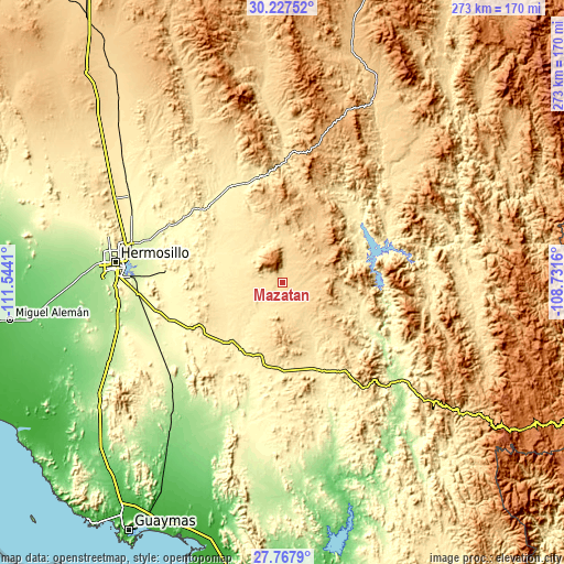
| \ | Map #1 | Topo.Map |
| Scale [m] | 510..710 m | × |
| Scale [ft] | 1673..2329 ft | × |
| Average | 562.8 m = 1846 ft | × |
| Width | 8.55 km = 5.3 mi | 273.5 km = 169.9 mi |
| Height | 8.55 km = 5.3 mi | 273.5 km = 169.9 mi |
| ↑Max Latitude | 29.043456° | 30.22752° |
| Latitude at center | 29.00503° | 29.00503° |
| ↓Min Latitude | 28.966589° | 27.7679° |
| ← Min Longitude | -110.181795° | -111.5441° |
| Longitude center | -110.13785° | -110.13785° |
| →Max Longitude | -110.093905° | -108.7316° |
Nearby cities:
Cities around Mazatán sort by population:
• Ures elevation 387 m
52.8 km,  332°
332°
• La Victoria 239 m
74.3 km,  280°
280°
• Molino de Camou 267 m
64.2 km,  290°
290°
• Suaqui Grande 242 m
72.2 km,  160°
160°
• San Pedro de la Cueva 350 m
50 km,  51°
51°
• Estación Zamora 280 m
78.1 km, 291°
• Villa Pesqueira 740 m
20.8 km, 52°
• Bacanora 453 m
71.8 km,  92°
92°
• San Miguel de Horcasitas 394 m
78.2 km,  313°
313°
• San Javier 757 m
59.8 km,  139°
139°
• La Colorada 387 m
48.5 km,  242°
242°
• Soyopa 229 m
55.8 km,  118°
118°
Multilingual:
 En español:
Mazatán elevación 547 m.
 En France:
Mazatán élévation 547 m.


Sources and notes:
- [note 1] Map square and city borders are not equal. Map elevation data is calculated only from area inside that square.
- [src 1] Elevation data from geonames database provided with same terms of usage.
- [src 2] The elevation map of Mazatán is generated using elevation data from NASA's 3 arcsec (90m) resolution SRTM data.
- [src 3] Base (background) map © OpenStreetMap contributors tiles are generated by Geofabrik and OpenTopoMap.
Copyright & License:
This Mazatán Elevation Map is licensed under CC BY-SA. You may reuse any part from this page, if you give a proper credit by linking to this URL:
 More info on terms of use page.