Mazatlán elevation
Mazatlán (Sinaloa), Mexico elevation is 10 meters and Mazatlán elevation in feet is 33 ft above sea level [src 1]. Mazatlán is a seat of a second-order administrative division (feature code) with elevation that is 1304 meters (4278 ft) smaller than average city elevation in Mexico.
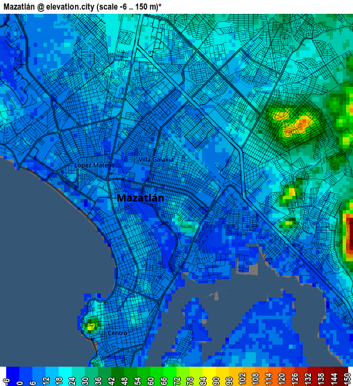
Below is the Elevation map of Mazatlán, which displays elevation range with different colors. Scale of the first map is from -6 to 150 m (-20 to 492 ft) with average elevation of 15.9 meters (=52 ft) [note 1]
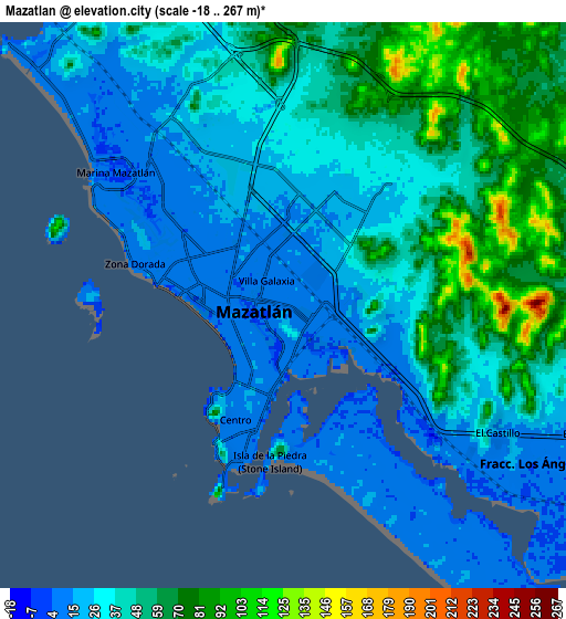
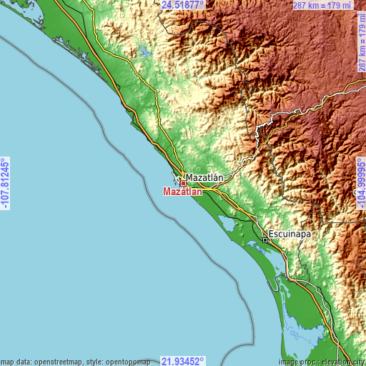
These maps also provides idea of topography and contour of this city, they are displayed at different zoom levels. More info about maps, scale and edge coordinates you can find below images.
| \ | Map #1 | Map #2 | Topo.Map |
| Scale [m] | -6..150 m | -18..267 m | × |
| Scale [ft] | -20..492 ft | -59..876 ft | × |
| Average | 15.9 m = 52 ft | 39.9 m = 131 ft | × |
| Width | 8.98 km = 5.6 mi | 17.96 km = 11.2 mi | 287.3 km = 178.5 mi |
| Height | 8.98 km = 5.6 mi | 17.96 km = 11.2 mi | 287.4 km = 178.6 mi |
| ↑Max Latitude | 23.273276° | 23.313639° | 24.51877° |
| Latitude at center | 23.2329° | 23.2329° | 23.2329° |
| ↓Min Latitude | 23.192512° | 23.152112° | 21.93452° |
| ← Min Longitude | -106.450145° | -106.494091° | -107.81245° |
| Longitude center | -106.4062° | -106.4062° | -106.4062° |
| →Max Longitude | -106.362255° | -106.318309° | -104.99995° |
Nearby cities:
Cities around Mazatlán sort by population:
• Villa Unión elevation 21 m
19.7 km,  104°
104°
• Fraccionamiento los Ángeles 8 m
9.2 km,  122°
122°
• El Walamo 12 m
19.4 km, 122°
• El Roble 32 m
20.5 km,  86°
86°
• El Castillo 14 m
8 km, 121°
• Barrón 8 m
18 km,  132°
132°
• El Verde 84 m
31.3 km,  62°
62°
• La Noria de San Antonio 121 m
31.8 km,  17°
17°
• El Habal 64 m
13.1 km,  354°
354°
• Escamillas 28 m
16.9 km,  74°
74°
• La Concepción 78 m
30.2 km,  53°
53°
• Siqueros 41 m
20.7 km, 54°
Multilingual:
 En español:
Ciudad Mazatlán, Mazatlán elevación 10 m.
 En France:
Mazatlán élévation 10 m.


Sources and notes:
- [note 1] Map square and city borders are not equal. Map elevation data is calculated only from area inside that square.
- [src 1] Elevation data from geonames database provided with same terms of usage.
- [src 2] The elevation map of Mazatlán is generated using elevation data from NASA's 3 arcsec (90m) resolution SRTM data.
- [src 3] Base (background) map © OpenStreetMap contributors tiles are generated by Geofabrik and OpenTopoMap.
Copyright & License:
This Mazatlán Elevation Map is licensed under CC BY-SA. You may reuse any part from this page, if you give a proper credit by linking to this URL:
 More info on terms of use page.