Moctezuma elevation
Moctezuma (Sonora), Mexico elevation is 638 meters and Moctezuma elevation in feet is 2093 ft above sea level [src 1]. Moctezuma is a seat of a second-order administrative division (feature code) with elevation that is 676 meters (2218 ft) smaller than average city elevation in Mexico.
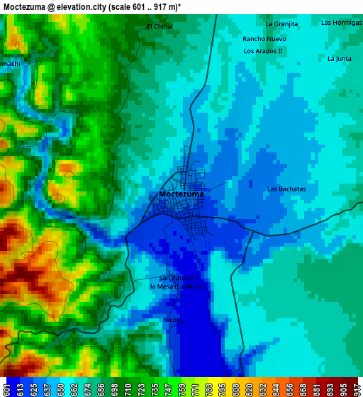
Below is the Elevation map of Moctezuma, which displays elevation range with different colors. Scale of the first map is from 601 to 917 m (1972 to 3009 ft) with average elevation of 682.4 meters (=2239 ft) [note 1]
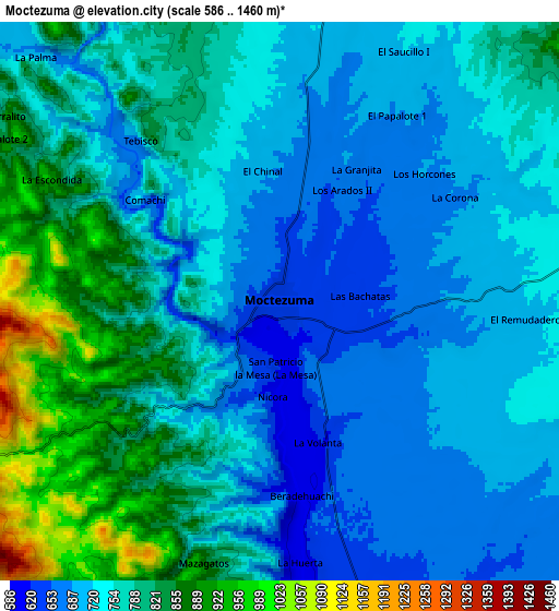
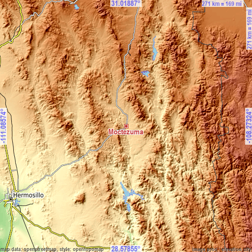
These maps also provides idea of topography and contour of this city, they are displayed at different zoom levels. More info about maps, scale and edge coordinates you can find below images.
| \ | Map #1 | Map #2 | Topo.Map |
| Scale [m] | 601..917 m | 586..1460 m | × |
| Scale [ft] | 1972..3009 ft | 1923..4790 ft | × |
| Average | 682.4 m = 2239 ft | 759.6 m = 2492 ft | × |
| Width | 8.48 km = 5.3 mi | 16.96 km = 10.5 mi | 271.3 km = 168.6 mi |
| Height | 8.48 km = 5.3 mi | 16.96 km = 10.5 mi | 271.3 km = 168.6 mi |
| ↑Max Latitude | 29.844275° | 29.882385° | 31.01887° |
| Latitude at center | 29.80615° | 29.80615° | 29.80615° |
| ↓Min Latitude | 29.768011° | 29.729857° | 28.57855° |
| ← Min Longitude | -109.723435° | -109.767381° | -111.08574° |
| Longitude center | -109.67949° | -109.67949° | -109.67949° |
| →Max Longitude | -109.635545° | -109.591599° | -108.27324° |
Nearby cities:
Cities around Moctezuma sort by population:
• Cumpas elevation 748 m
23.2 km,  335°
335°
• Baviácora 560 m
47.8 km,  257°
257°
• Aconchi 617 m
52.7 km,  272°
272°
• Villa Hidalgo 637 m
52.5 km,  41°
41°
• Tepache 601 m
33.6 km,  154°
154°
• Bacadéhuachi 702 m
52 km,  89°
89°
• Granados 537 m
36.2 km,  80°
80°
• Los Hoyos 809 m
36.7 km, 344°
• Huásabas 545 m
38.2 km,  72°
72°
• Divisaderos 685 m
29.4 km,  136°
136°
• Huépac 645 m
52.8 km,  282°
282°
• San Felipe de Jesús 623 m
54.2 km, 276°
Multilingual:
 En español:
Moctezuma elevación 638 m.
 En France:
Moctezuma élévation 638 m.
 Auf Deutsch:
Moctezuma höhe über dem Meeresspiegel ist 638 m.

Sources and notes:
- [note 1] Map square and city borders are not equal. Map elevation data is calculated only from area inside that square.
- [src 1] Elevation data from geonames database provided with same terms of usage.
- [src 2] The elevation map of Moctezuma is generated using elevation data from NASA's 3 arcsec (90m) resolution SRTM data.
- [src 3] Base (background) map © OpenStreetMap contributors tiles are generated by Geofabrik and OpenTopoMap.
Copyright & License:
This Moctezuma Elevation Map is licensed under CC BY-SA. You may reuse any part from this page, if you give a proper credit by linking to this URL:
 More info on terms of use page.