Nadadores elevation
Nadadores (Coahuila), Mexico elevation is 526 meters and Nadadores elevation in feet is 1726 ft above sea level [src 1]. Nadadores is a seat of a second-order administrative division (feature code) with elevation that is 788 meters (2585 ft) smaller than average city elevation in Mexico.
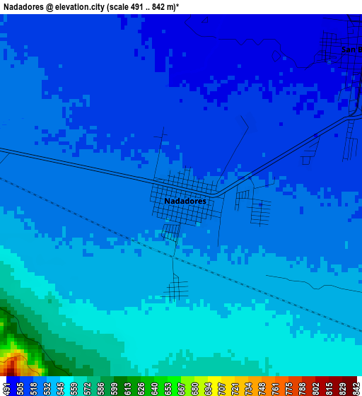
Below is the Elevation map of Nadadores, which displays elevation range with different colors. Scale of the first map is from 491 to 842 m (1611 to 2762 ft) with average elevation of 528.7 meters (=1735 ft) [note 1]
These maps also provides idea of topography and contour of this city, they are displayed at different zoom levels. More info about maps, scale and edge coordinates you can find below images.
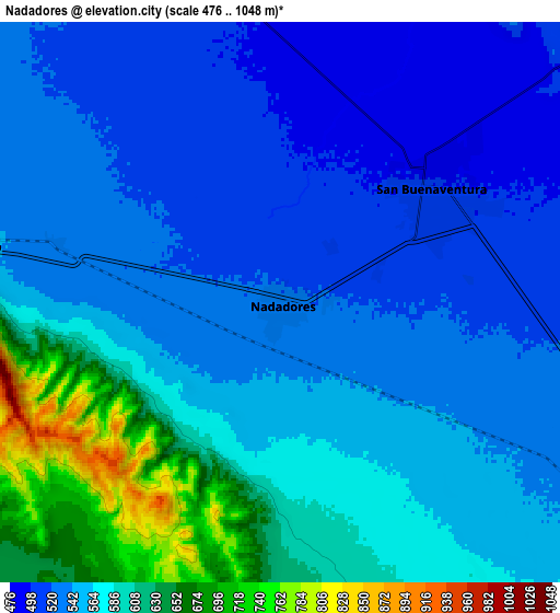
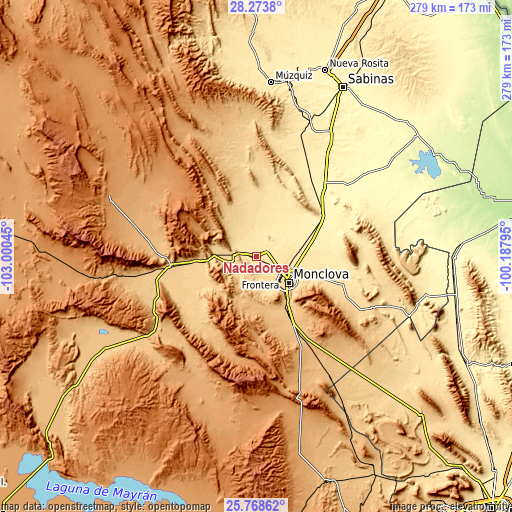
| \ | Map #1 | Map #2 | Topo.Map |
| Scale [m] | 491..842 m | 476..1048 m | × |
| Scale [ft] | 1611..2762 ft | 1562..3438 ft | × |
| Average | 528.7 m = 1735 ft | 561.4 m = 1842 ft | × |
| Width | 8.71 km = 5.4 mi | 17.41 km = 10.8 mi | 278.5 km = 173.1 mi |
| Height | 8.71 km = 5.4 mi | 17.41 km = 10.8 mi | 278.6 km = 173.1 mi |
| ↑Max Latitude | 27.067329° | 27.106454° | 28.2738° |
| Latitude at center | 27.02819° | 27.02819° | 27.02819° |
| ↓Min Latitude | 26.989037° | 26.949871° | 25.76862° |
| ← Min Longitude | -101.638145° | -101.682091° | -103.00045° |
| Longitude center | -101.5942° | -101.5942° | -101.5942° |
| →Max Longitude | -101.550255° | -101.506309° | -100.18795° |
Nearby cities:
Cities around Nadadores sort by population:
• Monclova elevation 603 m
21.9 km,  128°
128°
• Frontera 592 m
17.9 km, 128°
• Castaños 756 m
31 km,  148°
148°
• San Buenaventura 499 m
5.8 km,  50°
50°
• Sacramento 591 m
13.2 km,  257°
257°
• Colonia Diana Laura Riojas de Colosio 546 m
12.6 km,  116°
116°
• Lamadrid 651 m
20.1 km,  277°
277°
• Ocho de Enero 530 m
10.3 km,  109°
109°
• La Cruz 533 m
10.5 km, 111°
• Primero de Mayo 389 m
43.4 km,  57°
57°
• Abasolo 439 m
23.8 km,  43°
43°
• Escobedo 446 m
29 km, 38°
Multilingual:
 En español:
Nadadores elevación 526 m.
 En France:
Nadadores élévation 526 m.
 Auf Deutsch:
Nadadores höhe über dem Meeresspiegel ist 526 m.

Sources and notes:
- [note 1] Map square and city borders are not equal. Map elevation data is calculated only from area inside that square.
- [src 1] Elevation data from geonames database provided with same terms of usage.
- [src 2] The elevation map of Nadadores is generated using elevation data from NASA's 3 arcsec (90m) resolution SRTM data.
- [src 3] Base (background) map © OpenStreetMap contributors tiles are generated by Geofabrik and OpenTopoMap.
Copyright & License:
This Nadadores Elevation Map is licensed under CC BY-SA. You may reuse any part from this page, if you give a proper credit by linking to this URL:
 More info on terms of use page.