Navojoa elevation
Navojoa (Sonora), Mexico elevation is 47 meters and Navojoa elevation in feet is 154 ft above sea level [src 1]. Navojoa is a seat of a second-order administrative division (feature code) with elevation that is 1267 meters (4157 ft) smaller than average city elevation in Mexico.
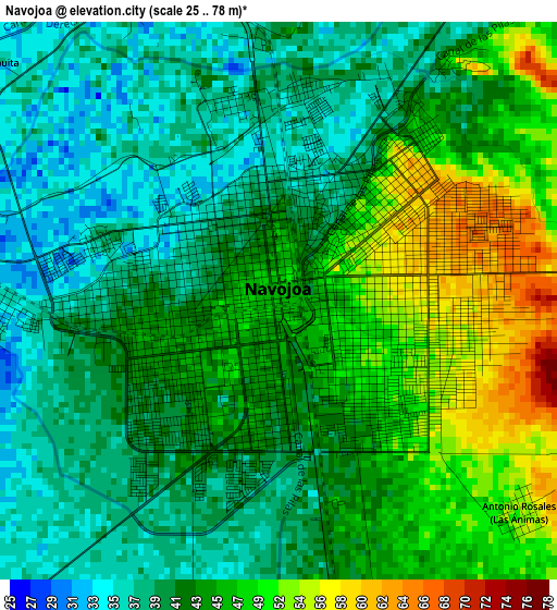
Below is the Elevation map of Navojoa, which displays elevation range with different colors. Scale of the first map is from 25 to 78 m (82 to 256 ft) with average elevation of 43.7 meters (=143 ft) [note 1]
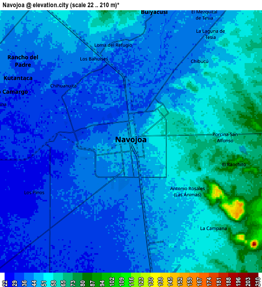
These maps also provides idea of topography and contour of this city, they are displayed at different zoom levels. More info about maps, scale and edge coordinates you can find below images.
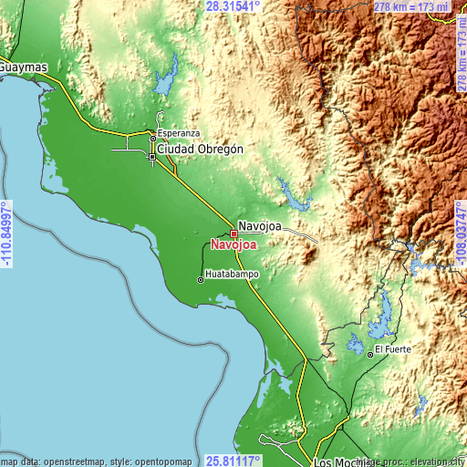
| \ | Map #1 | Map #2 | Topo.Map |
| Scale [m] | 25..78 m | 22..210 m | × |
| Scale [ft] | 82..256 ft | 72..689 ft | × |
| Average | 43.7 m = 143 ft | 46.3 m = 152 ft | × |
| Width | 8.7 km = 5.4 mi | 17.4 km = 10.8 mi | 278.4 km = 173 mi |
| Height | 8.7 km = 5.4 mi | 17.4 km = 10.8 mi | 278.5 km = 173.1 mi |
| ↑Max Latitude | 27.109404° | 27.148515° | 28.31541° |
| Latitude at center | 27.07028° | 27.07028° | 27.07028° |
| ↓Min Latitude | 27.031142° | 26.991991° | 25.81117° |
| ← Min Longitude | -109.487665° | -109.531611° | -110.84997° |
| Longitude center | -109.44372° | -109.44372° | -109.44372° |
| →Max Longitude | -109.399775° | -109.355829° | -108.03747° |
Nearby cities:
Cities around Navojoa sort by population:
• Bacame Nuevo elevation 51 m
17.8 km,  303°
303°
• Chucarit 27 m
14.6 km,  252°
252°
• Los Bahuises 41 m
5.7 km,  335°
335°
• Guaymitas 39 m
4.5 km,  6°
6°
• Rosales 43 m
7 km,  4°
4°
• Jitonhueca 31 m
16 km,  266°
266°
• Tierra Blanca 52 m
16.3 km,  36°
36°
• El Recodo 33 m
8.3 km,  275°
275°
• Siviral 37 m
6.8 km, 300°
• El Siviral (Jigica) 38 m
6.7 km, 302°
• Sinahuiza 42 m
17.7 km,  178°
178°
• Loma del Refugio 39 m
5.9 km,  345°
345°
Multilingual:
 En español:
Navojoa elevación 47 m.
 En France:
Navojoa élévation 47 m.


Sources and notes:
- [note 1] Map square and city borders are not equal. Map elevation data is calculated only from area inside that square.
- [src 1] Elevation data from geonames database provided with same terms of usage.
- [src 2] The elevation map of Navojoa is generated using elevation data from NASA's 3 arcsec (90m) resolution SRTM data.
- [src 3] Base (background) map © OpenStreetMap contributors tiles are generated by Geofabrik and OpenTopoMap.
Copyright & License:
This Navojoa Elevation Map is licensed under CC BY-SA. You may reuse any part from this page, if you give a proper credit by linking to this URL:
 More info on terms of use page.