Ortiz elevation
Ortiz (Sonora, Guaymas), Mexico elevation is 108 meters and Ortiz elevation in feet is 354 ft above sea level [src 1]. Ortiz is a populated place (feature code) with elevation that is 1206 meters (3957 ft) smaller than average city elevation in Mexico.
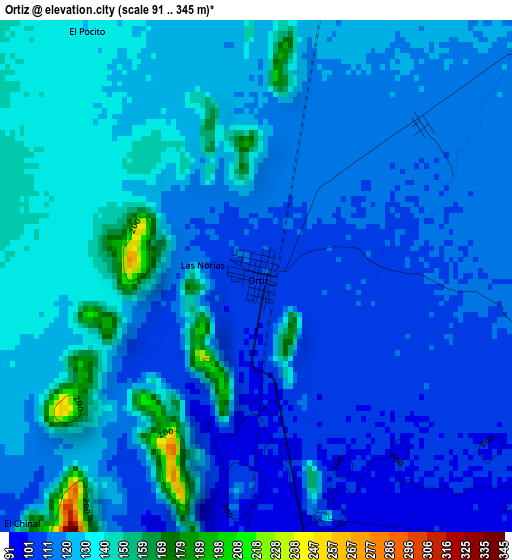
Below is the Elevation map of Ortiz, which displays elevation range with different colors. Scale of the first map is from 91 to 345 m (299 to 1132 ft) with average elevation of 122.5 meters (=402 ft) [note 1]
These maps also provides idea of topography and contour of this city, they are displayed at different zoom levels. More info about maps, scale and edge coordinates you can find below images.
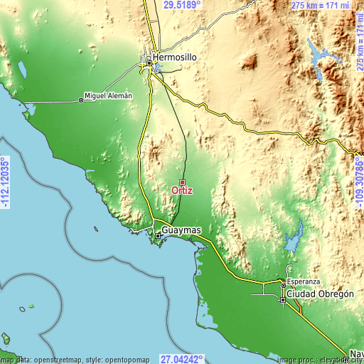
| \ | Map #1 | Topo.Map |
| Scale [m] | 91..345 m | × |
| Scale [ft] | 299..1132 ft | × |
| Average | 122.5 m = 402 ft | × |
| Width | 8.61 km = 5.3 mi | 275.4 km = 171.1 mi |
| Height | 8.61 km = 5.3 mi | 275.4 km = 171.1 mi |
| ↑Max Latitude | 28.32655° | 29.5189° |
| Latitude at center | 28.28786° | 28.28786° |
| ↓Min Latitude | 28.249156° | 27.04242° |
| ← Min Longitude | -110.758045° | -112.12035° |
| Longitude center | -110.7141° | -110.7141° |
| →Max Longitude | -110.670155° | -109.30785° |
Nearby cities:
Cities around Ortiz sort by population:
• Heroica Guaymas elevation 7 m
44.8 km,  203°
203°
• Empalme 7 m
37.6 km, 195°
• Potam 10 m
79.2 km,  158°
158°
• San Carlos 2 m
48.9 km,  221°
221°
• José María Morelos y Pavón 52 m
21.3 km,  173°
173°
• Guásimas (De Belem) 5 m
46.6 km, 163°
• Santa María de Guaymas 68 m
16.3 km, 172°
• Mi Patria es Primero 37 m
26.6 km, 172°
• La Palma 35 m
26.4 km,  177°
177°
• San José de Guaymas 7 m
37.3 km,  205°
205°
• Antonio Rosales 61 m
25.2 km, 157°
• La Colorada 387 m
58.8 km,  12°
12°
Multilingual:
 En español:
Ortiz elevación 108 m.
 En France:
Ortiz élévation 108 m.


Sources and notes:
- [note 1] Map square and city borders are not equal. Map elevation data is calculated only from area inside that square.
- [src 1] Elevation data from geonames database provided with same terms of usage.
- [src 2] The elevation map of Ortiz is generated using elevation data from NASA's 3 arcsec (90m) resolution SRTM data.
- [src 3] Base (background) map © OpenStreetMap contributors tiles are generated by Geofabrik and OpenTopoMap.
Copyright & License:
This Ortiz Elevation Map is licensed under CC BY-SA. You may reuse any part from this page, if you give a proper credit by linking to this URL:
 More info on terms of use page.