Pajacuarán elevation
Pajacuarán (Michoacán), Mexico elevation is 1528 meters and Pajacuarán elevation in feet is 5013 ft above sea level [src 1]. Pajacuarán is a seat of a second-order administrative division (feature code) with elevation that is 214 meters (702 ft) bigger than average city elevation in Mexico.
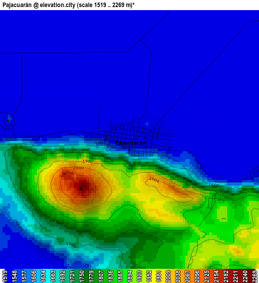
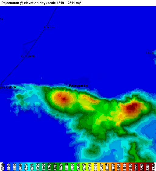
Below is the Elevation map of Pajacuarán, which displays elevation range with different colors. Scale of the first map is from 1519 to 2269 m (4984 to 7444 ft) with average elevation of 1654.8 meters (=5429 ft) [note 1]
These maps also provides idea of topography and contour of this city, they are displayed at different zoom levels. More info about maps, scale and edge coordinates you can find below images.
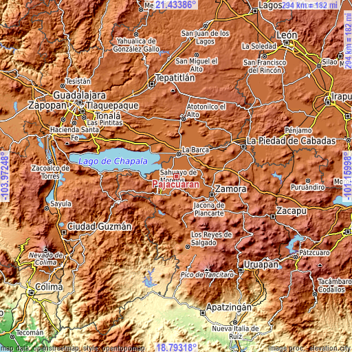
| \ | Map #1 | Map #2 | Topo.Map |
| Scale [m] | 1519..2269 m | 1519..2311 m | × |
| Scale [ft] | 4984..7444 ft | 4984..7582 ft | × |
| Average | 1654.8 m = 5429 ft | 1600.1 m = 5250 ft | × |
| Width | 9.18 km = 5.7 mi | 18.35 km = 11.4 mi | 293.6 km = 182.4 mi |
| Height | 9.18 km = 5.7 mi | 18.35 km = 11.4 mi | 293.6 km = 182.4 mi |
| ↑Max Latitude | 20.160348° | 20.201596° | 21.43386° |
| Latitude at center | 20.11909° | 20.11909° | 20.11909° |
| ↓Min Latitude | 20.077821° | 20.036541° | 18.79318° |
| ← Min Longitude | -102.610175° | -102.654121° | -103.97248° |
| Longitude center | -102.56623° | -102.56623° | -102.56623° |
| →Max Longitude | -102.522285° | -102.478339° | -101.15998° |
Nearby cities:
Cities around Pajacuarán sort by population:
• Venustiano Carranza elevation 1531 m
9.2 km,  267°
267°
• La Luz 1531 m
9.2 km,  66°
66°
• Villamar 1536 m
11.4 km,  196°
196°
• Morelos 1531 m
6.7 km,  299°
299°
• Fraccionamiento San Miguel 1527 m
13.7 km,  247°
247°
• El Platanal 1530 m
6.5 km,  190°
190°
• San Gregorio 1531 m
8.6 km,  12°
12°
• La Plaza del Limón 1540 m
14.2 km,  82°
82°
• Ibarra 1527 m
13.7 km,  333°
333°
• Tecomatán 1529 m
7.3 km,  93°
93°
• El Fortín 1527 m
7.7 km, 332°
• El Paracho 1537 m
4.7 km,  104°
104°
Multilingual:
 En español:
Pajacuarán elevación 1528 m.
 En France:
Pajacuarán élévation 1528 m.
 Auf Deutsch:
Pajacuarán höhe über dem Meeresspiegel ist 1528 m.

Sources and notes:
- [note 1] Map square and city borders are not equal. Map elevation data is calculated only from area inside that square.
- [src 1] Elevation data from geonames database provided with same terms of usage.
- [src 2] The elevation map of Pajacuarán is generated using elevation data from NASA's 3 arcsec (90m) resolution SRTM data.
- [src 3] Base (background) map © OpenStreetMap contributors tiles are generated by Geofabrik and OpenTopoMap.
Copyright & License:
This Pajacuarán Elevation Map is licensed under CC BY-SA. You may reuse any part from this page, if you give a proper credit by linking to this URL:
 More info on terms of use page.