Panindícuaro elevation
Panindícuaro (Michoacán), Mexico elevation is 1827 meters and Panindícuaro elevation in feet is 5994 ft above sea level [src 1]. Panindícuaro is a seat of a second-order administrative division (feature code) with elevation that is 513 meters (1683 ft) bigger than average city elevation in Mexico.
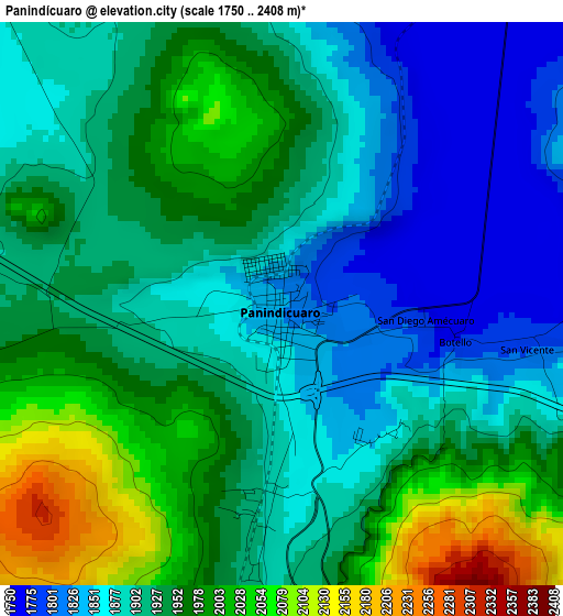
Below is the Elevation map of Panindícuaro, which displays elevation range with different colors. Scale of the first map is from 1750 to 2408 m (5741 to 7900 ft) with average elevation of 1926.1 meters (=6319 ft) [note 1]
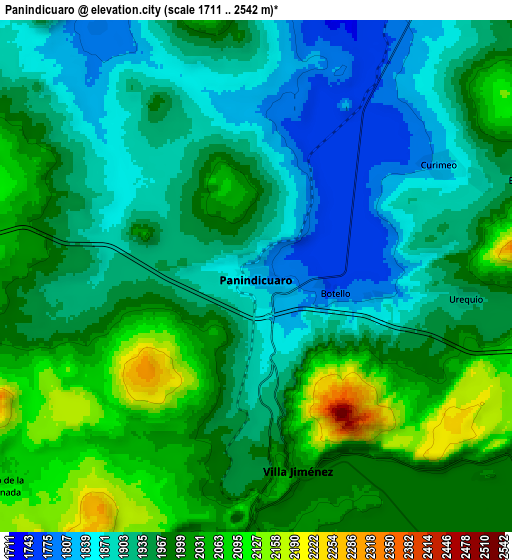
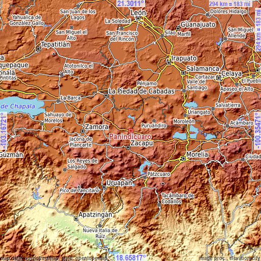
These maps also provides idea of topography and contour of this city, they are displayed at different zoom levels. More info about maps, scale and edge coordinates you can find below images.
| \ | Map #1 | Map #2 | Topo.Map |
| Scale [m] | 1750..2408 m | 1711..2542 m | × |
| Scale [ft] | 5741..7900 ft | 5614..8340 ft | × |
| Average | 1926.1 m = 6319 ft | 1957.4 m = 6422 ft | × |
| Width | 9.18 km = 5.7 mi | 18.37 km = 11.4 mi | 293.9 km = 182.6 mi |
| Height | 9.18 km = 5.7 mi | 18.37 km = 11.4 mi | 293.9 km = 182.6 mi |
| ↑Max Latitude | 20.026474° | 20.067756° | 21.3011° |
| Latitude at center | 19.98518° | 19.98518° | 19.98518° |
| ↓Min Latitude | 19.943876° | 19.90256° | 18.65817° |
| ← Min Longitude | -101.804905° | -101.848851° | -103.16721° |
| Longitude center | -101.76096° | -101.76096° | -101.76096° |
| →Max Longitude | -101.717015° | -101.673069° | -100.35471° |
Nearby cities:
Cities around Panindícuaro sort by population:
• Zacapu elevation 1988 m
18.4 km,  189°
189°
• Angamacutiro de la Unión 1705 m
19 km,  15°
15°
• Villa Jiménez 2011 m
7.1 km,  168°
168°
• Cantabria 1986 m
16.5 km, 167°
• Caurio de Guadalupe 2071 m
12.4 km,  237°
237°
• Ziquítaro 1826 m
16 km,  302°
302°
• San Lorenzo 1991 m
12 km,  87°
87°
• Copándaro (Copándaro del Cuatro) 1991 m
14.2 km,  131°
131°
• San Miguel Epejan 1797 m
10.7 km,  327°
327°
• Curimeo 1834 m
7.9 km,  60°
60°
• San Antonio Tariácuri 2024 m
11.5 km, 172°
• Agua Caliente 1731 m
9.3 km, 17°
Multilingual:
 En español:
Panindícuaro elevación 1827 m.
 En France:
Panindícuaro élévation 1827 m.
 Auf Deutsch:
Panindícuaro höhe über dem Meeresspiegel ist 1827 m.

Sources and notes:
- [note 1] Map square and city borders are not equal. Map elevation data is calculated only from area inside that square.
- [src 1] Elevation data from geonames database provided with same terms of usage.
- [src 2] The elevation map of Panindícuaro is generated using elevation data from NASA's 3 arcsec (90m) resolution SRTM data.
- [src 3] Base (background) map © OpenStreetMap contributors tiles are generated by Geofabrik and OpenTopoMap.
Copyright & License:
This Panindícuaro Elevation Map is licensed under CC BY-SA. You may reuse any part from this page, if you give a proper credit by linking to this URL:
 More info on terms of use page.