Rancho Viejo elevation
Rancho Viejo (Guanajuato, San Miguel de Allende), Mexico elevation is 1885 meters and Rancho Viejo elevation in feet is 6184 ft above sea level [src 1]. Rancho Viejo is a populated place (feature code) with elevation that is 571 meters (1873 ft) bigger than average city elevation in Mexico.
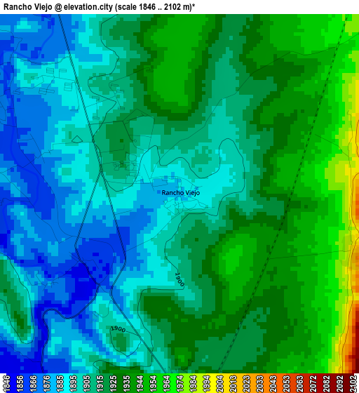
Below is the Elevation map of Rancho Viejo, which displays elevation range with different colors. Scale of the first map is from 1846 to 2102 m (6056 to 6896 ft) with average elevation of 1914.8 meters (=6282 ft) [note 1]
These maps also provides idea of topography and contour of this city, they are displayed at different zoom levels. More info about maps, scale and edge coordinates you can find below images.
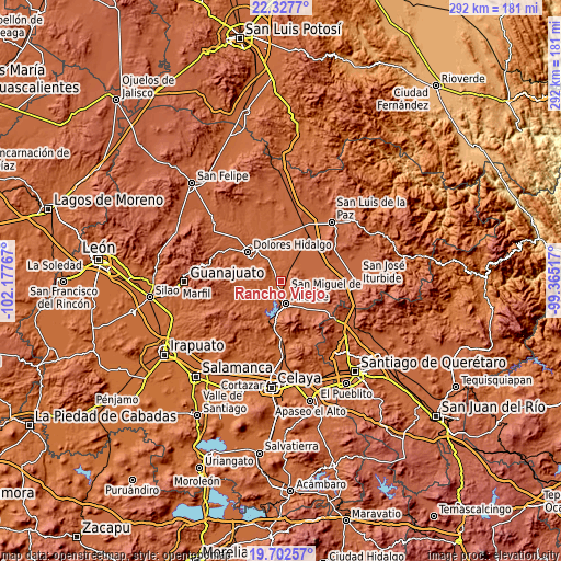
| \ | Map #1 | Topo.Map |
| Scale [m] | 1846..2102 m | × |
| Scale [ft] | 6056..6896 ft | × |
| Average | 1914.8 m = 6282 ft | × |
| Width | 9.12 km = 5.7 mi | 291.9 km = 181.4 mi |
| Height | 9.12 km = 5.7 mi | 291.9 km = 181.4 mi |
| ↑Max Latitude | 21.061925° | 22.3277° |
| Latitude at center | 21.02091° | 21.02091° |
| ↓Min Latitude | 20.979884° | 19.70257° |
| ← Min Longitude | -100.815365° | -102.17767° |
| Longitude center | -100.77142° | -100.77142° |
| →Max Longitude | -100.727475° | -99.36517° |
Nearby cities:
Cities around Rancho Viejo sort by population:
• San Miguel de Allende elevation 1917 m
12.1 km,  166°
166°
• Los Rodríguez 2013 m
13.5 km,  79°
79°
• Colonia San Luis Rey 1936 m
10.2 km,  158°
158°
• Tequisquiapan 1879 m
8.3 km,  322°
322°
• Los Galvan 1882 m
5.7 km,  327°
327°
• San Gabriel 1895 m
13.8 km, 331°
• La Cieneguita 1857 m
8.5 km,  192°
192°
• Jamaica 1967 m
14.2 km,  15°
15°
• Palo Colorado 2005 m
4.6 km,  107°
107°
• Nigromante 1891 m
6.6 km, 187°
• Adjuntas del Río 1914 m
14.6 km, 316°
• La Cruz del Palmar 1866 m
9.4 km,  232°
232°
Multilingual:
 En español:
Rancho Viejo elevación 1885 m.
 En France:
Rancho Viejo élévation 1885 m.
 Auf Deutsch:
Rancho Viejo höhe über dem Meeresspiegel ist 1885 m.

Sources and notes:
- [note 1] Map square and city borders are not equal. Map elevation data is calculated only from area inside that square.
- [src 1] Elevation data from geonames database provided with same terms of usage.
- [src 2] The elevation map of Rancho Viejo is generated using elevation data from NASA's 3 arcsec (90m) resolution SRTM data.
- [src 3] Base (background) map © OpenStreetMap contributors tiles are generated by Geofabrik and OpenTopoMap.
Copyright & License:
This Rancho Viejo Elevation Map is licensed under CC BY-SA. You may reuse any part from this page, if you give a proper credit by linking to this URL:
 More info on terms of use page.