Sain Alto elevation
Sain Alto (Zacatecas), Mexico elevation is 2051 meters and Sain Alto elevation in feet is 6729 ft above sea level [src 1]. Sain Alto is a seat of a second-order administrative division (feature code) with elevation that is 737 meters (2418 ft) bigger than average city elevation in Mexico.
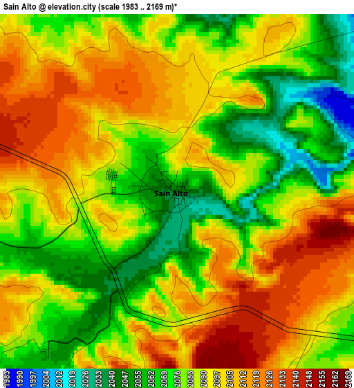
Below is the Elevation map of Sain Alto, which displays elevation range with different colors. Scale of the first map is from 1983 to 2169 m (6506 to 7116 ft) with average elevation of 2088.4 meters (=6852 ft) [note 1]
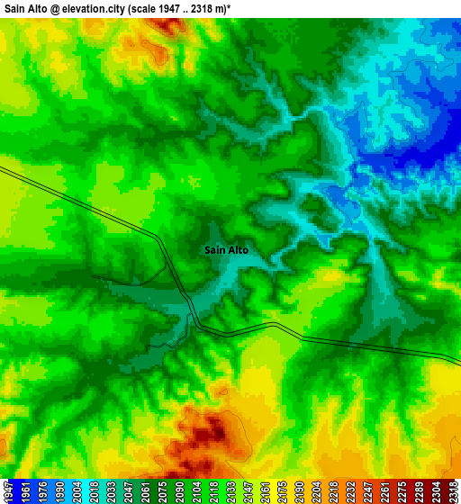
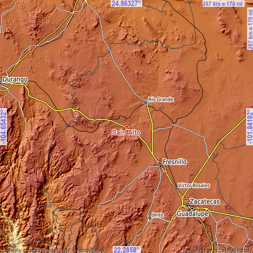
These maps also provides idea of topography and contour of this city, they are displayed at different zoom levels. More info about maps, scale and edge coordinates you can find below images.
| \ | Map #1 | Map #2 | Topo.Map |
| Scale [m] | 1983..2169 m | 1947..2318 m | × |
| Scale [ft] | 6506..7116 ft | 6388..7605 ft | × |
| Average | 2088.4 m = 6852 ft | 2101.6 m = 6895 ft | × |
| Width | 8.96 km = 5.6 mi | 17.91 km = 11.1 mi | 286.6 km = 178.1 mi |
| Height | 8.96 km = 5.6 mi | 17.91 km = 11.1 mi | 286.6 km = 178.1 mi |
| ↑Max Latitude | 23.62113° | 23.661387° | 24.86327° |
| Latitude at center | 23.58086° | 23.58086° | 23.58086° |
| ↓Min Latitude | 23.540578° | 23.500284° | 22.2858° |
| ← Min Longitude | -103.292015° | -103.335961° | -104.65432° |
| Longitude center | -103.24807° | -103.24807° | -103.24807° |
| →Max Longitude | -103.204125° | -103.160179° | -101.84182° |
Nearby cities:
Cities around Sain Alto sort by population:
• Seis de Enero elevation 2121 m
29.5 km,  143°
143°
• Rio de Medina 2001 m
25 km,  110°
110°
• Emiliano Zapata 1988 m
16.4 km,  20°
20°
• Emiliano Zapata 2069 m
5.6 km,  259°
259°
• Colonia Francisco García Salinas 1957 m
26.4 km,  14°
14°
• Cañas 2043 m
18.1 km,  1°
1°
• José María Morelos (Santa Mónica) 1965 m
14.3 km,  78°
78°
• El Cazadero 1939 m
16.4 km,  51°
51°
• Pastelera 1914 m
23.8 km,  40°
40°
• La Florida 1884 m
30.4 km, 35°
• Sain Bajo 1970 m
8.5 km,  62°
62°
• Cantuna 2120 m
11.1 km,  295°
295°
Multilingual:
 En español:
Sain Alto elevación 2051 m.
 En France:
Sain Alto élévation 2051 m.
 Auf Deutsch:
Sain Alto höhe über dem Meeresspiegel ist 2051 m.

Sources and notes:
- [note 1] Map square and city borders are not equal. Map elevation data is calculated only from area inside that square.
- [src 1] Elevation data from geonames database provided with same terms of usage.
- [src 2] The elevation map of Sain Alto is generated using elevation data from NASA's 3 arcsec (90m) resolution SRTM data.
- [src 3] Base (background) map © OpenStreetMap contributors tiles are generated by Geofabrik and OpenTopoMap.
Copyright & License:
This Sain Alto Elevation Map is licensed under CC BY-SA. You may reuse any part from this page, if you give a proper credit by linking to this URL:
 More info on terms of use page.