San Felipe elevation
San Felipe (Guanajuato), Mexico elevation is 2089 meters and San Felipe elevation in feet is 6854 ft above sea level [src 1]. San Felipe is a seat of a second-order administrative division (feature code) with elevation that is 775 meters (2543 ft) bigger than average city elevation in Mexico.
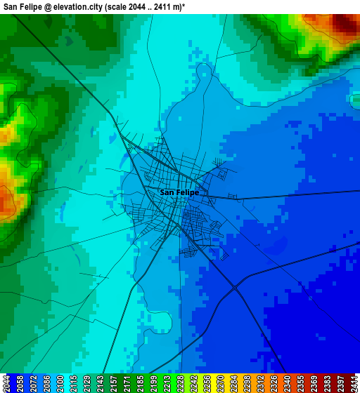
Below is the Elevation map of San Felipe, which displays elevation range with different colors. Scale of the first map is from 2044 to 2411 m (6706 to 7910 ft) with average elevation of 2109.5 meters (=6921 ft) [note 1]
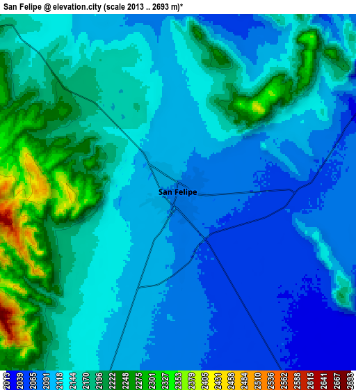
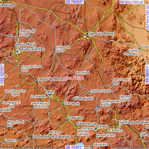
These maps also provides idea of topography and contour of this city, they are displayed at different zoom levels. More info about maps, scale and edge coordinates you can find below images.
| \ | Map #1 | Map #2 | Topo.Map |
| Scale [m] | 2044..2411 m | 2013..2693 m | × |
| Scale [ft] | 6706..7910 ft | 6604..8835 ft | × |
| Average | 2109.5 m = 6921 ft | 2140.4 m = 7022 ft | × |
| Width | 9.09 km = 5.6 mi | 18.19 km = 11.3 mi | 291 km = 180.8 mi |
| Height | 9.09 km = 5.6 mi | 18.19 km = 11.3 mi | 291 km = 180.8 mi |
| ↑Max Latitude | 21.519198° | 21.560074° | 22.78093° |
| Latitude at center | 21.47831° | 21.47831° | 21.47831° |
| ↓Min Latitude | 21.437411° | 21.3965° | 20.16393° |
| ← Min Longitude | -101.259605° | -101.303551° | -102.62191° |
| Longitude center | -101.21566° | -101.21566° | -101.21566° |
| →Max Longitude | -101.171715° | -101.127769° | -99.80941° |
Nearby cities:
Cities around San Felipe sort by population:
• Ocampo elevation 2267 m
33.1 km,  304°
304°
• San Bartolo de Berrios 1878 m
21.3 km,  45°
45°
• San Juan Pan de Arriba 2111 m
30.6 km,  91°
91°
• El Carretón 1876 m
29.6 km,  55°
55°
• Santa Bárbara 2229 m
18 km,  291°
291°
• Santa Catarina 1905 m
16.7 km,  65°
65°
• Santa Rosa 1911 m
15.2 km, 57°
• San José de Rancho Nuevo (Los Arrieros) 1890 m
25.5 km, 59°
• San José del Torreón 2160 m
26.4 km,  269°
269°
• San Francisco 1882 m
23.7 km,  43°
43°
• Molino de San José 2122 m
11.4 km,  334°
334°
• Chirimoya (Estación Chirimoya) 1877 m
18.1 km, 45°
Multilingual:
 En español:
San Felipe elevación 2089 m.
 En France:
San Felipe élévation 2089 m.
 Auf Deutsch:
San Felipe höhe über dem Meeresspiegel ist 2089 m.

Sources and notes:
- [note 1] Map square and city borders are not equal. Map elevation data is calculated only from area inside that square.
- [src 1] Elevation data from geonames database provided with same terms of usage.
- [src 2] The elevation map of San Felipe is generated using elevation data from NASA's 3 arcsec (90m) resolution SRTM data.
- [src 3] Base (background) map © OpenStreetMap contributors tiles are generated by Geofabrik and OpenTopoMap.
Copyright & License:
This San Felipe Elevation Map is licensed under CC BY-SA. You may reuse any part from this page, if you give a proper credit by linking to this URL:
 More info on terms of use page.