San Lorenzo elevation
San Lorenzo (Guanajuato, Celaya), Mexico elevation is 1811 meters and San Lorenzo elevation in feet is 5942 ft above sea level [src 1]. San Lorenzo is a populated place (feature code) with elevation that is 497 meters (1631 ft) bigger than average city elevation in Mexico.
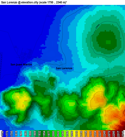
Below is the Elevation map of San Lorenzo, which displays elevation range with different colors. Scale of the first map is from 1750 to 2340 m (5741 to 7677 ft) with average elevation of 1879.3 meters (=6166 ft) [note 1]
These maps also provides idea of topography and contour of this city, they are displayed at different zoom levels. More info about maps, scale and edge coordinates you can find below images.
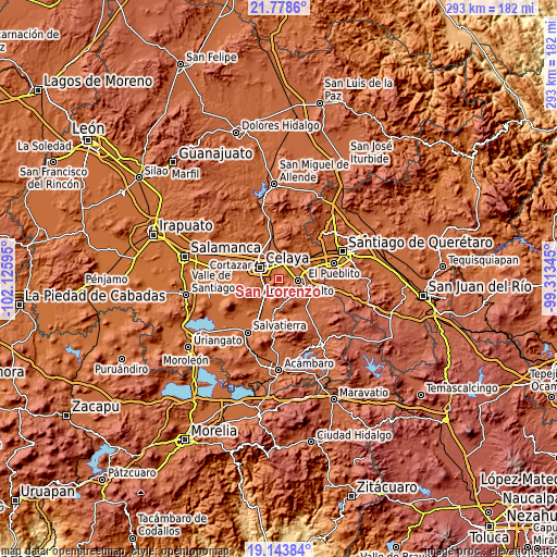
| \ | Map #1 | Topo.Map |
| Scale [m] | 1750..2340 m | × |
| Scale [ft] | 5741..7677 ft | × |
| Average | 1879.3 m = 6166 ft | × |
| Width | 9.16 km = 5.7 mi | 293 km = 182.1 mi |
| Height | 9.16 km = 5.7 mi | 293 km = 182.1 mi |
| ↑Max Latitude | 20.508036° | 21.7786° |
| Latitude at center | 20.46687° | 20.46687° |
| ↓Min Latitude | 20.425693° | 19.14384° |
| ← Min Longitude | -100.763645° | -102.12595° |
| Longitude center | -100.7197° | -100.7197° |
| →Max Longitude | -100.675755° | -99.31345° |
Nearby cities:
Cities around San Lorenzo sort by population:
• Rincón de Tamayo elevation 1800 m
6.1 km,  217°
217°
• San José de Agua Azul 1815 m
7 km,  71°
71°
• Juan Martín 1763 m
2.9 km,  283°
283°
• Tenango el Nuevo 1776 m
8.7 km,  34°
34°
• La Palma 1786 m
5.9 km,  22°
22°
• La Laja 1758 m
8.2 km,  327°
327°
• Estancia del Llano 1766 m
5 km,  351°
351°
• La Cruz 1758 m
8 km,  262°
262°
• La Labor 1771 m
7.7 km,  13°
13°
• Los Mancera 1756 m
8.8 km,  272°
272°
• San José el Nuevo 1771 m
6 km,  244°
244°
• La Purísima 1790 m
7.2 km,  42°
42°
Multilingual:
 En español:
San Lorenzo elevación 1811 m.
 En France:
San Lorenzo élévation 1811 m.
 Auf Deutsch:
San Lorenzo höhe über dem Meeresspiegel ist 1811 m.

Sources and notes:
- [note 1] Map square and city borders are not equal. Map elevation data is calculated only from area inside that square.
- [src 1] Elevation data from geonames database provided with same terms of usage.
- [src 2] The elevation map of San Lorenzo is generated using elevation data from NASA's 3 arcsec (90m) resolution SRTM data.
- [src 3] Base (background) map © OpenStreetMap contributors tiles are generated by Geofabrik and OpenTopoMap.
Copyright & License:
This San Lorenzo Elevation Map is licensed under CC BY-SA. You may reuse any part from this page, if you give a proper credit by linking to this URL:
 More info on terms of use page.