San Lucas Texcaltitlán elevation
San Lucas Texcaltitlán (State of Mexico, Donato Guerra), Mexico elevation is 2146 meters and San Lucas Texcaltitlán elevation in feet is 7041 ft above sea level [src 1]. San Lucas Texcaltitlán is a populated place (feature code) with elevation that is 832 meters (2730 ft) bigger than average city elevation in Mexico.
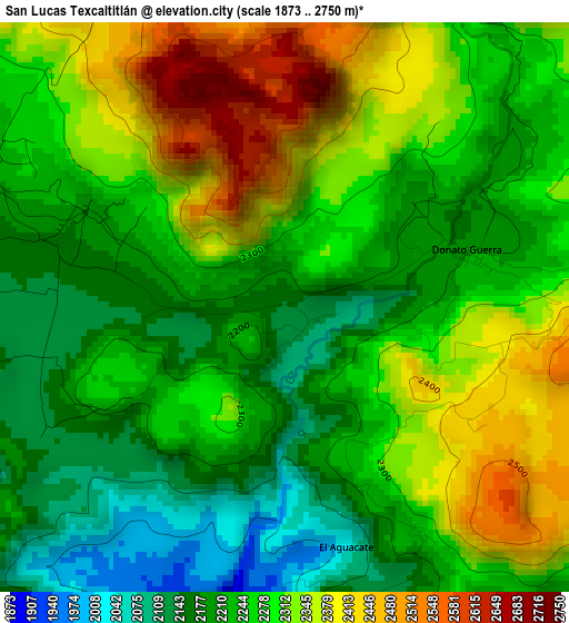
Below is the Elevation map of San Lucas Texcaltitlán, which displays elevation range with different colors. Scale of the first map is from 1873 to 2750 m (6145 to 9022 ft) with average elevation of 2272.4 meters (=7455 ft) [note 1]
These maps also provides idea of topography and contour of this city, they are displayed at different zoom levels. More info about maps, scale and edge coordinates you can find below images.
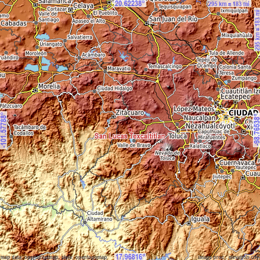
| \ | Map #1 | Topo.Map |
| Scale [m] | 1873..2750 m | × |
| Scale [ft] | 6145..9022 ft | × |
| Average | 2272.4 m = 7455 ft | × |
| Width | 9.22 km = 5.7 mi | 295.1 km = 183.4 mi |
| Height | 9.22 km = 5.7 mi | 295.1 km = 183.4 mi |
| ↑Max Latitude | 19.34212° | 20.62238° |
| Latitude at center | 19.30065° | 19.30065° |
| ↓Min Latitude | 19.259169° | 17.96816° |
| ← Min Longitude | -100.215575° | -101.57788° |
| Longitude center | -100.17163° | -100.17163° |
| →Max Longitude | -100.127685° | -98.76538° |
Nearby cities:
Cities around San Lucas Texcaltitlán sort by population:
• San Simón de la Laguna elevation 2487 m
9.6 km,  95°
95°
• San Agustín de las Palmas 2329 m
3.7 km,  39°
39°
• San Juan Xoconusco 2067 m
9.3 km,  277°
277°
• El Arco 1814 m
9.4 km,  153°
153°
• Santiago Huitlapaltepec 2173 m
4 km,  247°
247°
• Vare Chiquichuca 2520 m
6.6 km,  338°
338°
• San Gabriel Ixtla 2189 m
6.9 km,  133°
133°
• San Jerónimo Totoltepec 2192 m
3.6 km,  295°
295°
• San José Villa de Allende 2384 m
8.6 km,  16°
16°
• Barrio Chiquichuca 2245 m
4.9 km, 298°
• San Ildefonso 2348 m
6.5 km,  33°
33°
• Cabecera de Indígenas 2432 m
8.8 km, 24°
Multilingual:
 En español:
San Lucas Texcaltitlán elevación 2146 m.
 En France:
San Lucas Texcaltitlán élévation 2146 m.
 Auf Deutsch:
San Lucas Texcaltitlán höhe über dem Meeresspiegel ist 2146 m.
 На русском:
San Lucas Texcaltitlán высота над уровнем моря 2146 м
Sources and notes:
- [note 1] Map square and city borders are not equal. Map elevation data is calculated only from area inside that square.
- [src 1] Elevation data from geonames database provided with same terms of usage.
- [src 2] The elevation map of San Lucas Texcaltitlán is generated using elevation data from NASA's 3 arcsec (90m) resolution SRTM data.
- [src 3] Base (background) map © OpenStreetMap contributors tiles are generated by Geofabrik and OpenTopoMap.
Copyright & License:
This San Lucas Texcaltitlán Elevation Map is licensed under CC BY-SA. You may reuse any part from this page, if you give a proper credit by linking to this URL:
 More info on terms of use page.