San Luis Potosí elevation
San Luis Potosí, Mexico elevation is 1875 meters and San Luis Potosí elevation in feet is 6152 ft above sea level [src 1]. San Luis Potosí is a seat of a first-order administrative division (feature code) with elevation that is 561 meters (1841 ft) bigger than average city elevation in Mexico.
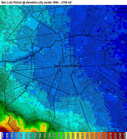
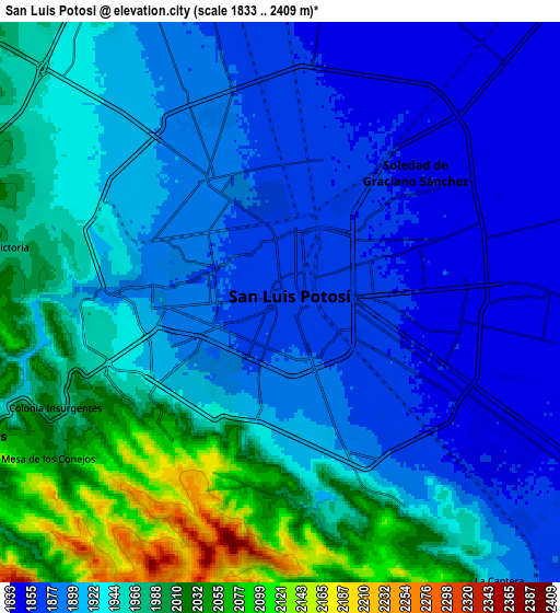
Below is the Elevation map of San Luis Potosí, which displays elevation range with different colors. Scale of the first map is from 1844 to 2155 m (6050 to 7070 ft) with average elevation of 1884.2 meters (=6182 ft) [note 1]
These maps also provides idea of topography and contour of this city, they are displayed at different zoom levels. More info about maps, scale and edge coordinates you can find below images.
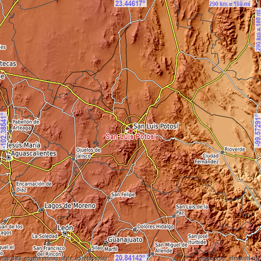
| \ | Map #1 | Map #2 | Topo.Map |
| Scale [m] | 1844..2155 m | 1833..2409 m | × |
| Scale [ft] | 6050..7070 ft | 6014..7904 ft | × |
| Average | 1884.2 m = 6182 ft | 1931.5 m = 6337 ft | × |
| Width | 9.05 km = 5.6 mi | 18.1 km = 11.2 mi | 289.6 km = 179.9 mi |
| Height | 9.05 km = 5.6 mi | 18.1 km = 11.2 mi | 289.6 km = 179.9 mi |
| ↑Max Latitude | 22.190516° | 22.231201° | 23.44617° |
| Latitude at center | 22.14982° | 22.14982° | 22.14982° |
| ↓Min Latitude | 22.109112° | 22.068392° | 20.84142° |
| ← Min Longitude | -101.023105° | -101.067051° | -102.38541° |
| Longitude center | -100.97916° | -100.97916° | -100.97916° |
| →Max Longitude | -100.935215° | -100.891269° | -99.57291° |
Nearby cities:
Cities around San Luis Potosí sort by population:
• Soledad de Graciano Sánchez elevation 1853 m
6.1 km,  44°
44°
• Escalerillas 1955 m
10.6 km,  246°
246°
• Rancho Nuevo 1843 m
9.9 km, 35°
• Monte Obscuro 1911 m
9.3 km,  326°
326°
• Fracción Milpillas 1850 m
8.8 km,  10°
10°
• Maravillas 1876 m
10.4 km,  341°
341°
• Paisanos 1919 m
8.4 km,  315°
315°
• Rinconada 1841 m
11.9 km, 14°
• Guadalupe Victoria 1991 m
9.5 km,  279°
279°
• Agua Señora 1910 m
11.7 km, 326°
• La Mesa de los Conejos 2056 m
9.2 km,  235°
235°
• Paso Blanco 1963 m
11.3 km,  303°
303°
Multilingual:
 En español:
San Luis Potosí elevación 1875 m.
 En France:
San Luis Potosí élévation 1875 m.
 Auf Deutsch:
San Luis Potosí höhe über dem Meeresspiegel ist 1875 m.

Sources and notes:
- [note 1] Map square and city borders are not equal. Map elevation data is calculated only from area inside that square.
- [src 1] Elevation data from geonames database provided with same terms of usage.
- [src 2] The elevation map of San Luis Potosí is generated using elevation data from NASA's 3 arcsec (90m) resolution SRTM data.
- [src 3] Base (background) map © OpenStreetMap contributors tiles are generated by Geofabrik and OpenTopoMap.
Copyright & License:
This San Luis Potosí Elevation Map is licensed under CC BY-SA. You may reuse any part from this page, if you give a proper credit by linking to this URL:
 More info on terms of use page.