San Pedro Piedra Gorda elevation
San Pedro Piedra Gorda (Zacatecas, Cuauhtémoc), Mexico elevation is 2024 meters and San Pedro Piedra Gorda elevation in feet is 6640 ft above sea level [src 1]. San Pedro Piedra Gorda is a seat of a second-order administrative division (feature code) with elevation that is 710 meters (2329 ft) bigger than average city elevation in Mexico.
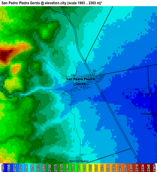
Below is the Elevation map of San Pedro Piedra Gorda, which displays elevation range with different colors. Scale of the first map is from 1983 to 2363 m (6506 to 7753 ft) with average elevation of 2065.8 meters (=6778 ft) [note 1]
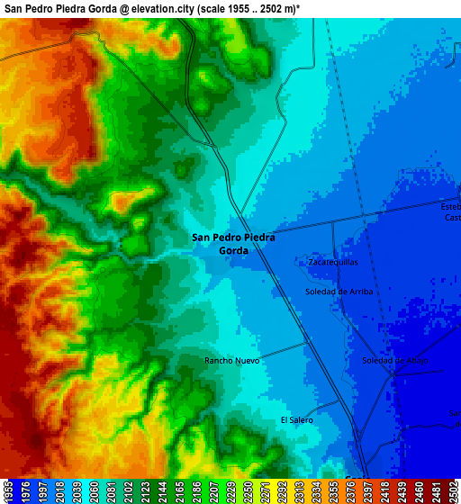
These maps also provides idea of topography and contour of this city, they are displayed at different zoom levels. More info about maps, scale and edge coordinates you can find below images.
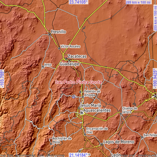
| \ | Map #1 | Map #2 | Topo.Map |
| Scale [m] | 1983..2363 m | 1955..2502 m | × |
| Scale [ft] | 6506..7753 ft | 6414..8209 ft | × |
| Average | 2065.8 m = 6778 ft | 2130.5 m = 6990 ft | × |
| Width | 9.03 km = 5.6 mi | 18.06 km = 11.2 mi | 289 km = 179.6 mi |
| Height | 9.03 km = 5.6 mi | 18.06 km = 11.2 mi | 289 km = 179.6 mi |
| ↑Max Latitude | 22.48814° | 22.528737° | 23.74105° |
| Latitude at center | 22.44753° | 22.44753° | 22.44753° |
| ↓Min Latitude | 22.406908° | 22.366275° | 21.14184° |
| ← Min Longitude | -102.392695° | -102.436641° | -103.755° |
| Longitude center | -102.34875° | -102.34875° | -102.34875° |
| →Max Longitude | -102.304805° | -102.260859° | -100.9425° |
Nearby cities:
Cities around San Pedro Piedra Gorda sort by population:
• Luis Moya elevation 1983 m
10.4 km,  99°
99°
• Cosío 2005 m
10.3 km,  151°
151°
• La Punta 1957 m
14.9 km,  157°
157°
• San Jacinto 1949 m
16.2 km,  132°
132°
• Genaro Codina 2162 m
12 km,  291°
291°
• Rancho Nuevo 2060 m
4.4 km,  179°
179°
• La Concepción 2019 m
11.4 km,  48°
48°
• El Refugio de Providencia (Providencia) 1951 m
14.6 km,  140°
140°
• El Salero 2035 m
7.2 km, 158°
• Santa María de la Paz 1962 m
11.5 km, 125°
• Paso de Méndez 2237 m
14.6 km,  301°
301°
• Piedra Gorda 2069 m
6.9 km,  14°
14°
Multilingual:
 En español:
San Pedro Piedra Gorda elevación 2024 m.
 En France:
San Pedro Piedra Gorda élévation 2024 m.
 Auf Deutsch:
San Pedro Piedra Gorda höhe über dem Meeresspiegel ist 2024 m.
 На русском:
San Pedro Piedra Gorda высота над уровнем моря 2024 м
Sources and notes:
- [note 1] Map square and city borders are not equal. Map elevation data is calculated only from area inside that square.
- [src 1] Elevation data from geonames database provided with same terms of usage.
- [src 2] The elevation map of San Pedro Piedra Gorda is generated using elevation data from NASA's 3 arcsec (90m) resolution SRTM data.
- [src 3] Base (background) map © OpenStreetMap contributors tiles are generated by Geofabrik and OpenTopoMap.
Copyright & License:
This San Pedro Piedra Gorda Elevation Map is licensed under CC BY-SA. You may reuse any part from this page, if you give a proper credit by linking to this URL:
 More info on terms of use page.