Santa Cruz del Valle elevation
Santa Cruz del Valle (Jalisco, Tlajomulco de Zúñiga), Mexico elevation is 1567 meters and Santa Cruz del Valle elevation in feet is 5141 ft above sea level [src 1]. Santa Cruz del Valle is a populated place (feature code) with elevation that is 253 meters (830 ft) bigger than average city elevation in Mexico.
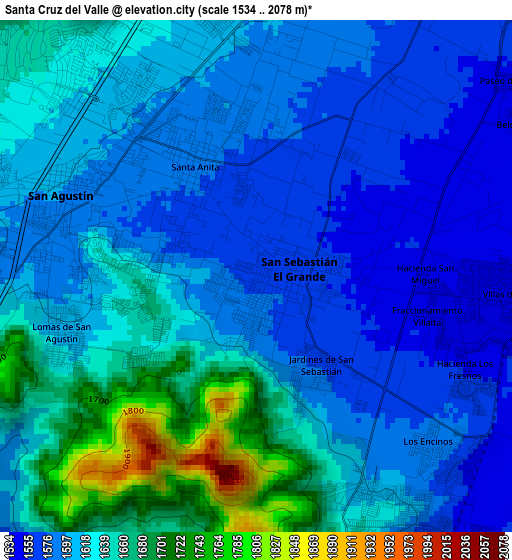
Below is the Elevation map of Santa Cruz del Valle, which displays elevation range with different colors. Scale of the first map is from 1534 to 2078 m (5033 to 6818 ft) with average elevation of 1616.2 meters (=5302 ft) [note 1]
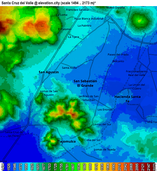
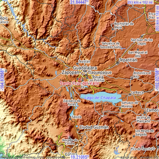
These maps also provides idea of topography and contour of this city, they are displayed at different zoom levels. More info about maps, scale and edge coordinates you can find below images.
| \ | Map #1 | Map #2 | Topo.Map |
| Scale [m] | 1534..2078 m | 1494..2173 m | × |
| Scale [ft] | 5033..6818 ft | 4902..7129 ft | × |
| Average | 1616.2 m = 5302 ft | 1628.6 m = 5343 ft | × |
| Width | 9.15 km = 5.7 mi | 18.3 km = 11.4 mi | 292.8 km = 181.9 mi |
| Height | 9.15 km = 5.7 mi | 18.3 km = 11.4 mi | 292.8 km = 181.9 mi |
| ↑Max Latitude | 20.574478° | 20.615615° | 21.84447° |
| Latitude at center | 20.53333° | 20.53333° | 20.53333° |
| ↓Min Latitude | 20.492171° | 20.451001° | 19.21085° |
| ← Min Longitude | -103.477275° | -103.521221° | -104.83958° |
| Longitude center | -103.43333° | -103.43333° | -103.43333° |
| →Max Longitude | -103.389385° | -103.345439° | -102.02708° |
Nearby cities:
Cities around Santa Cruz del Valle sort by population:
• Nicolás R Casillas elevation 1594 m
3.7 km,  292°
292°
• San Sebastián el Grande 1569 m
0.6 km,  96°
96°
• Santa Anita 1578 m
2.2 km,  330°
330°
• Lomas del Sur 1636 m
4.8 km,  160°
160°
• La Tijera 1615 m
5.4 km,  352°
352°
• Lomas de San Agustín 1599 m
3.6 km,  259°
259°
• Villas de la Hacienda [Fraccionamiento] 1536 m
5.3 km,  92°
92°
• Colinas del Roble 1560 m
4.9 km,  131°
131°
• Hacienda los Fresnos 1548 m
4.5 km,  110°
110°
• Jardines de San Sebastián 1570 m
2 km,  144°
144°
• Los Gavilanes 1617 m
4.9 km,  340°
340°
• La Roca 1602 m
2.4 km, 162°
Multilingual:
 En español:
Santa Cruz del Valle elevación 1567 m.
 En France:
Santa Cruz del Valle élévation 1567 m.
 Auf Deutsch:
Santa Cruz del Valle höhe über dem Meeresspiegel ist 1567 m.
 На русском:
Santa Cruz del Valle высота над уровнем моря 1567 м
Sources and notes:
- [note 1] Map square and city borders are not equal. Map elevation data is calculated only from area inside that square.
- [src 1] Elevation data from geonames database provided with same terms of usage.
- [src 2] The elevation map of Santa Cruz del Valle is generated using elevation data from NASA's 3 arcsec (90m) resolution SRTM data.
- [src 3] Base (background) map © OpenStreetMap contributors tiles are generated by Geofabrik and OpenTopoMap.
Copyright & License:
This Santa Cruz del Valle Elevation Map is licensed under CC BY-SA. You may reuse any part from this page, if you give a proper credit by linking to this URL:
 More info on terms of use page.