Santiago elevation
Santiago (Aguascalientes, Pabellón de Arteaga), Mexico elevation is 1911 meters and Santiago elevation in feet is 6270 ft above sea level [src 1]. Santiago is a populated place (feature code) with elevation that is 597 meters (1959 ft) bigger than average city elevation in Mexico.
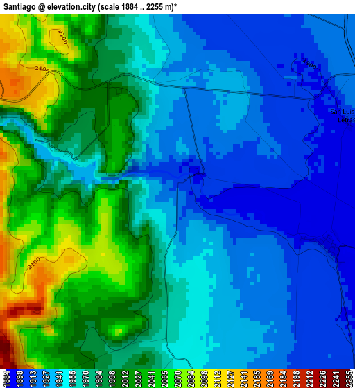
Below is the Elevation map of Santiago, which displays elevation range with different colors. Scale of the first map is from 1884 to 2255 m (6181 to 7398 ft) with average elevation of 1970.3 meters (=6464 ft) [note 1]
These maps also provides idea of topography and contour of this city, they are displayed at different zoom levels. More info about maps, scale and edge coordinates you can find below images.
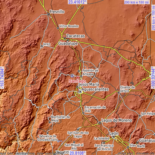
| \ | Map #1 | Topo.Map |
| Scale [m] | 1884..2255 m | × |
| Scale [ft] | 6181..7398 ft | × |
| Average | 1970.3 m = 6464 ft | × |
| Width | 9.05 km = 5.6 mi | 289.7 km = 180 mi |
| Height | 9.05 km = 5.6 mi | 289.7 km = 180 mi |
| ↑Max Latitude | 22.160185° | 23.41612° |
| Latitude at center | 22.11948° | 22.11948° |
| ↓Min Latitude | 22.078763° | 20.8108° |
| ← Min Longitude | -102.381635° | -103.74394° |
| Longitude center | -102.33769° | -102.33769° |
| →Max Longitude | -102.293745° | -100.93144° |
Nearby cities:
Cities around Santiago sort by population:
• Pabellón de Arteaga elevation 1910 m
6.9 km,  64°
64°
• Rincón de Romos 1945 m
12.2 km,  7°
7°
• San Francisco de los Romo 1897 m
8.3 km,  124°
124°
• San José de Gracia 2048 m
8.6 km,  292°
292°
• Pabellón de Hidalgo 1934 m
6.6 km,  357°
357°
• Emiliano Zapata 1886 m
4.1 km,  110°
110°
• Las Ánimas 1893 m
8 km, 113°
• La Concepción 1881 m
10.1 km,  157°
157°
• Valladolid 1876 m
11.2 km,  167°
167°
• Carboneras 1911 m
11.8 km,  53°
53°
• Santa Isabel [Fraccionamiento] 1891 m
8.4 km, 120°
• San Luis de Letras 1898 m
4.5 km,  66°
66°
Multilingual:
 En español:
Santiago elevación 1911 m.
 En France:
Santiago élévation 1911 m.
 Auf Deutsch:
Santiago höhe über dem Meeresspiegel ist 1911 m.

Sources and notes:
- [note 1] Map square and city borders are not equal. Map elevation data is calculated only from area inside that square.
- [src 1] Elevation data from geonames database provided with same terms of usage.
- [src 2] The elevation map of Santiago is generated using elevation data from NASA's 3 arcsec (90m) resolution SRTM data.
- [src 3] Base (background) map © OpenStreetMap contributors tiles are generated by Geofabrik and OpenTopoMap.
Copyright & License:
This Santiago Elevation Map is licensed under CC BY-SA. You may reuse any part from this page, if you give a proper credit by linking to this URL:
 More info on terms of use page.