Santiago Ixcuintla elevation
Santiago Ixcuintla (Nayarit), Mexico elevation is 18 meters and Santiago Ixcuintla elevation in feet is 59 ft above sea level [src 1]. Santiago Ixcuintla is a seat of a second-order administrative division (feature code) with elevation that is 1296 meters (4252 ft) smaller than average city elevation in Mexico.
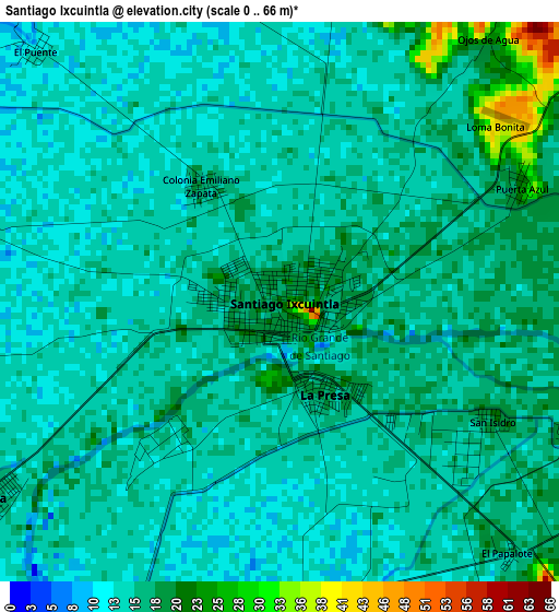
Below is the Elevation map of Santiago Ixcuintla, which displays elevation range with different colors. Scale of the first map is from 0 to 66 m (0 to 217 ft) with average elevation of 15.6 meters (=51 ft) [note 1]
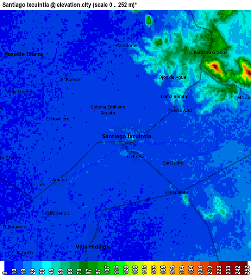
These maps also provides idea of topography and contour of this city, they are displayed at different zoom levels. More info about maps, scale and edge coordinates you can find below images.
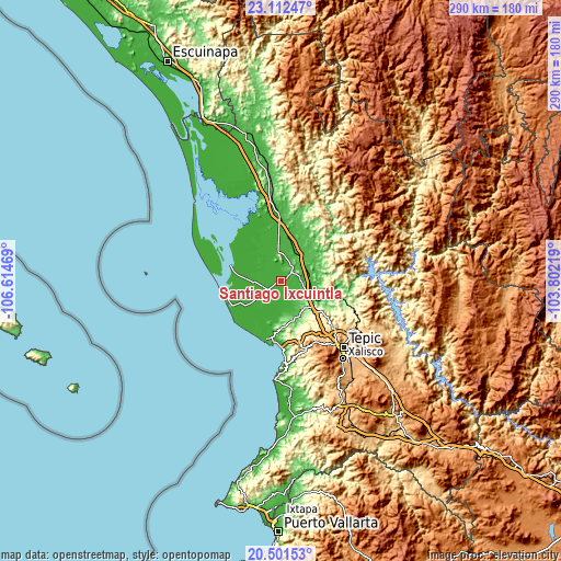
| \ | Map #1 | Map #2 | Topo.Map |
| Scale [m] | 0..66 m | 0..252 m | × |
| Scale [ft] | 0..217 ft | 0..827 ft | × |
| Average | 15.6 m = 51 ft | 19.6 m = 64 ft | × |
| Width | 9.07 km = 5.6 mi | 18.15 km = 11.3 mi | 290.3 km = 180.4 mi |
| Height | 9.07 km = 5.6 mi | 18.15 km = 11.3 mi | 290.3 km = 180.4 mi |
| ↑Max Latitude | 21.853743° | 21.894525° | 23.11247° |
| Latitude at center | 21.81295° | 21.81295° | 21.81295° |
| ↓Min Latitude | 21.772145° | 21.731329° | 20.50153° |
| ← Min Longitude | -105.252385° | -105.296331° | -106.61469° |
| Longitude center | -105.20844° | -105.20844° | -105.20844° |
| →Max Longitude | -105.164495° | -105.120549° | -103.80219° |
Nearby cities:
Cities around Santiago Ixcuintla sort by population:
• Villa Hidalgo elevation 13 m
8.2 km,  196°
196°
• La Presa 18 m
1.6 km,  152°
152°
• Pozo de Ibarra 13 m
9.5 km,  309°
309°
• Cuamiles 12 m
13.2 km,  339°
339°
• Sentispac 10 m
14.2 km,  266°
266°
• Amapa 17 m
5.8 km,  235°
235°
• Sauta 40 m
12.3 km, 146°
• El Corte 12 m
11 km, 200°
• Colonia Emiliano Zapata 15 m
2.1 km,  326°
326°
• El Capomal 35 m
9.5 km,  71°
71°
• El Tizate 24 m
9.6 km,  97°
97°
• El Botadero 10 m
10.4 km,  230°
230°
Multilingual:
 En español:
Santiago Ixcuintla elevación 18 m.
 En France:
Santiago Ixcuintla élévation 18 m.
 Auf Deutsch:
Santiago Ixcuintla höhe über dem Meeresspiegel ist 18 m.

Sources and notes:
- [note 1] Map square and city borders are not equal. Map elevation data is calculated only from area inside that square.
- [src 1] Elevation data from geonames database provided with same terms of usage.
- [src 2] The elevation map of Santiago Ixcuintla is generated using elevation data from NASA's 3 arcsec (90m) resolution SRTM data.
- [src 3] Base (background) map © OpenStreetMap contributors tiles are generated by Geofabrik and OpenTopoMap.
Copyright & License:
This Santiago Ixcuintla Elevation Map is licensed under CC BY-SA. You may reuse any part from this page, if you give a proper credit by linking to this URL:
 More info on terms of use page.