San Vicente elevation
San Vicente (Baja California, Ensenada), Mexico elevation is 109 meters and San Vicente elevation in feet is 358 ft above sea level [src 1]. San Vicente is a populated place (feature code) with elevation that is 1205 meters (3953 ft) smaller than average city elevation in Mexico.
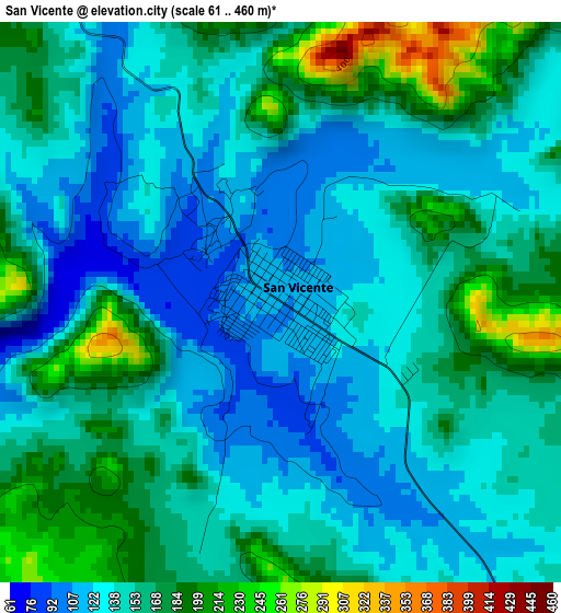
Below is the Elevation map of San Vicente, which displays elevation range with different colors. Scale of the first map is from 61 to 460 m (200 to 1509 ft) with average elevation of 150.6 meters (=494 ft) [note 1]
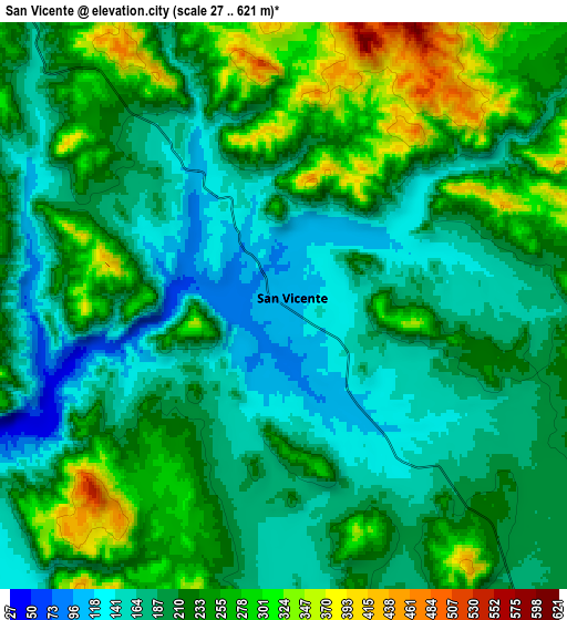
These maps also provides idea of topography and contour of this city, they are displayed at different zoom levels. More info about maps, scale and edge coordinates you can find below images.
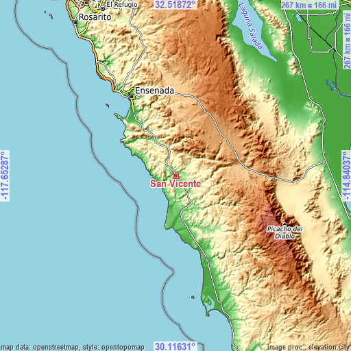
| \ | Map #1 | Map #2 | Topo.Map |
| Scale [m] | 61..460 m | 27..621 m | × |
| Scale [ft] | 200..1509 ft | 89..2037 ft | × |
| Average | 150.6 m = 494 ft | 215 m = 705 ft | × |
| Width | 8.35 km = 5.2 mi | 16.7 km = 10.4 mi | 267.1 km = 166 mi |
| Height | 8.35 km = 5.2 mi | 16.7 km = 10.4 mi | 267.1 km = 166 mi |
| ↑Max Latitude | 31.362712° | 31.400229° | 32.51872° |
| Latitude at center | 31.32518° | 31.32518° | 31.32518° |
| ↓Min Latitude | 31.287633° | 31.250071° | 30.11631° |
| ← Min Longitude | -116.290565° | -116.334511° | -117.65287° |
| Longitude center | -116.24662° | -116.24662° | -116.24662° |
| →Max Longitude | -116.202675° | -116.158729° | -114.84037° |
Nearby cities:
Cities around San Vicente sort by population:
• Ensenada elevation 29 m
69.4 km,  331°
331°
• Rodolfo Sánchez Taboada 34 m
53.7 km,  324°
324°
• Camalú 32 m
56.5 km,  161°
161°
• Benito García (El Zorrillo) 129 m
45.9 km, 326°
• Emiliano Zapata 41 m
67.6 km, 159°
• Salvador Rosas Magallón 234 m
70.1 km,  336°
336°
• Poblado Chulavista (El Chorizo) 34 m
68.3 km, 160°
• Licenciado Gustavo Díaz Ordaz 60 m
39.9 km,  167°
167°
• Colonia Gómez Morín 279 m
68 km, 335°
• La Providencia 49 m
40.5 km, 168°
• Las Brisas 36 m
41.3 km, 169°
• Fraccionamiento del Valle 703 m
65.2 km,  358°
358°
Multilingual:
 En español:
San Vicente elevación 109 m.
 En France:
San Vicente élévation 109 m.
 Auf Deutsch:
San Vicente höhe über dem Meeresspiegel ist 109 m.

Sources and notes:
- [note 1] Map square and city borders are not equal. Map elevation data is calculated only from area inside that square.
- [src 1] Elevation data from geonames database provided with same terms of usage.
- [src 2] The elevation map of San Vicente is generated using elevation data from NASA's 3 arcsec (90m) resolution SRTM data.
- [src 3] Base (background) map © OpenStreetMap contributors tiles are generated by Geofabrik and OpenTopoMap.
Copyright & License:
This San Vicente Elevation Map is licensed under CC BY-SA. You may reuse any part from this page, if you give a proper credit by linking to this URL:
 More info on terms of use page.