Villanueva elevation
Villanueva (Zacatecas), Mexico elevation is 1898 meters and Villanueva elevation in feet is 6227 ft above sea level [src 1]. Villanueva is a seat of a second-order administrative division (feature code) with elevation that is 584 meters (1916 ft) bigger than average city elevation in Mexico.
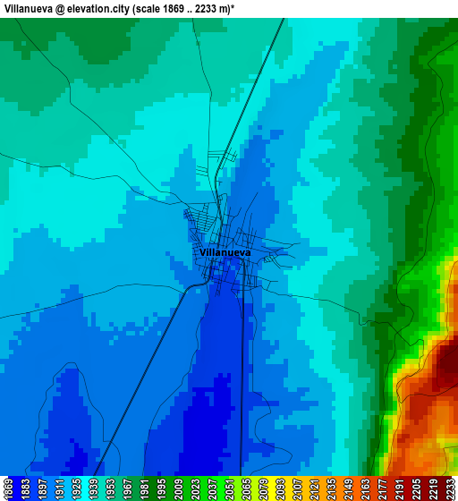
Below is the Elevation map of Villanueva, which displays elevation range with different colors. Scale of the first map is from 1869 to 2233 m (6132 to 7326 ft) with average elevation of 1943.1 meters (=6375 ft) [note 1]
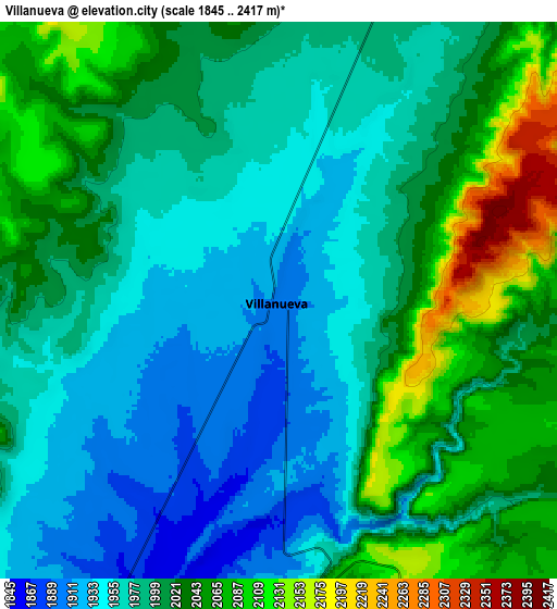
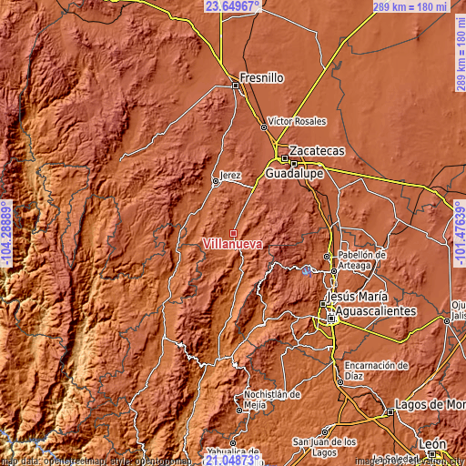
These maps also provides idea of topography and contour of this city, they are displayed at different zoom levels. More info about maps, scale and edge coordinates you can find below images.
| \ | Map #1 | Map #2 | Topo.Map |
| Scale [m] | 1869..2233 m | 1845..2417 m | × |
| Scale [ft] | 6132..7326 ft | 6053..7930 ft | × |
| Average | 1943.1 m = 6375 ft | 2001.2 m = 6566 ft | × |
| Width | 9.04 km = 5.6 mi | 18.08 km = 11.2 mi | 289.2 km = 179.7 mi |
| Height | 9.04 km = 5.6 mi | 18.08 km = 11.2 mi | 289.2 km = 179.7 mi |
| ↑Max Latitude | 22.395907° | 22.436531° | 23.64967° |
| Latitude at center | 22.35527° | 22.35527° | 22.35527° |
| ↓Min Latitude | 22.314622° | 22.273961° | 21.04873° |
| ← Min Longitude | -102.926585° | -102.970531° | -104.28889° |
| Longitude center | -102.88264° | -102.88264° | -102.88264° |
| →Max Longitude | -102.838695° | -102.794749° | -101.47639° |
Nearby cities:
Cities around Villanueva sort by population:
• Jerez de García Salinas elevation 2001 m
34.6 km,  341°
341°
• Huejúcar 1842 m
33.8 km,  270°
270°
• Malpaso 2152 m
32.6 km,  22°
22°
• Ermita de Guadalupe 1962 m
29.8 km,  329°
329°
• Tayahua 1705 m
29.1 km,  177°
177°
• Tepetongo 1939 m
29.9 km,  292°
292°
• Genaro Codina 2162 m
46.1 km,  71°
71°
• Colonia Felipe Ángeles 2088 m
23.4 km, 23°
• Paredes 2033 m
47.1 km,  119°
119°
• Paso de Méndez 2237 m
46.1 km, 67°
• Santa María de los Ángeles 1704 m
40.6 km,  240°
240°
• Susticacán 2036 m
35.8 km,  322°
322°
Multilingual:
 En español:
Villanueva elevación 1898 m.
 En France:
Villanueva élévation 1898 m.
 Auf Deutsch:
Villanueva höhe über dem Meeresspiegel ist 1898 m.

Sources and notes:
- [note 1] Map square and city borders are not equal. Map elevation data is calculated only from area inside that square.
- [src 1] Elevation data from geonames database provided with same terms of usage.
- [src 2] The elevation map of Villanueva is generated using elevation data from NASA's 3 arcsec (90m) resolution SRTM data.
- [src 3] Base (background) map © OpenStreetMap contributors tiles are generated by Geofabrik and OpenTopoMap.
Copyright & License:
This Villanueva Elevation Map is licensed under CC BY-SA. You may reuse any part from this page, if you give a proper credit by linking to this URL:
 More info on terms of use page.