Zamora elevation
Zamora (Michoacán), Mexico elevation is 1570 meters and Zamora elevation in feet is 5151 ft above sea level [src 1]. Zamora is a populated place (feature code) with elevation that is 256 meters (840 ft) bigger than average city elevation in Mexico.
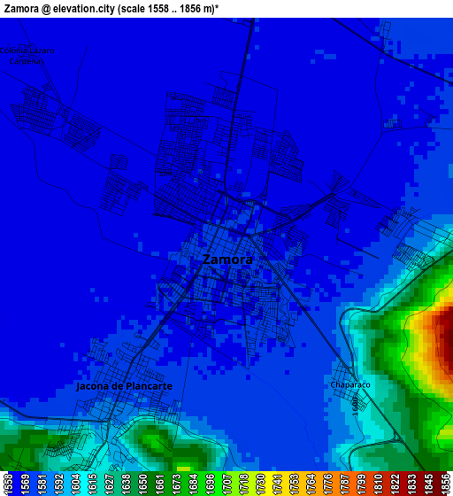
Below is the Elevation map of Zamora, which displays elevation range with different colors. Scale of the first map is from 1558 to 1856 m (5112 to 6089 ft) with average elevation of 1581.5 meters (=5189 ft) [note 1]
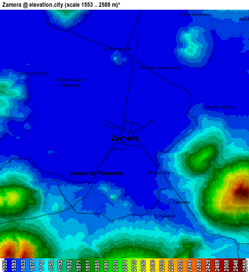
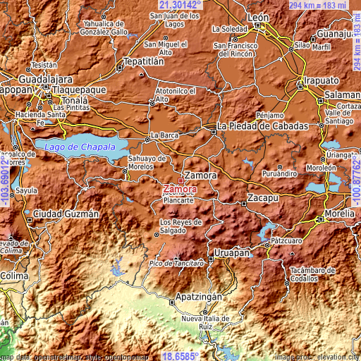
These maps also provides idea of topography and contour of this city, they are displayed at different zoom levels. More info about maps, scale and edge coordinates you can find below images.
| \ | Map #1 | Map #2 | Topo.Map |
| Scale [m] | 1558..1856 m | 1553..2588 m | × |
| Scale [ft] | 5112..6089 ft | 5095..8491 ft | × |
| Average | 1581.5 m = 5189 ft | 1664.3 m = 5460 ft | × |
| Width | 9.18 km = 5.7 mi | 18.37 km = 11.4 mi | 293.9 km = 182.6 mi |
| Height | 9.18 km = 5.7 mi | 18.37 km = 11.4 mi | 293.9 km = 182.6 mi |
| ↑Max Latitude | 20.026793° | 20.068076° | 21.30142° |
| Latitude at center | 19.9855° | 19.9855° | 19.9855° |
| ↓Min Latitude | 19.944196° | 19.902881° | 18.6585° |
| ← Min Longitude | -102.327815° | -102.371761° | -103.69012° |
| Longitude center | -102.28387° | -102.28387° | -102.28387° |
| →Max Longitude | -102.239925° | -102.195979° | -100.87762° |
Nearby cities:
Cities around Zamora sort by population:
• Jacona de Plancarte elevation 1596 m
4.5 km,  214°
214°
• Ario de Rayón 1569 m
8.1 km,  304°
304°
• La Rinconoda 1590 m
6.5 km,  355°
355°
• Atecucario de la Constitución (Atecuario) 1591 m
10 km,  28°
28°
• Chaparaco 1592 m
3.7 km,  139°
139°
• Fraccionamiento Ex-Hacienda el Refugio 1607 m
4.8 km, 143°
• Fraccionamiento Monte Olivo 1578 m
3.4 km,  91°
91°
• Aquiles Serdán 1587 m
7.4 km,  74°
74°
• Tamándaro 1591 m
4 km,  180°
180°
• La Estancia de Amezcua 1569 m
4.7 km,  59°
59°
• Romero de Torres 1571 m
5.4 km,  36°
36°
• Romero de Guzmán 1573 m
5.6 km, 28°
Multilingual:
 En español:
Zamora de Hidalgo elevación 1570 m.
 En France:
Zamora élévation 1570 m.
 Auf Deutsch:
Zamora höhe über dem Meeresspiegel ist 1570 m.
 На русском:
Самора-де-Идальго высота над уровнем моря 1570 м
Sources and notes:
- [note 1] Map square and city borders are not equal. Map elevation data is calculated only from area inside that square.
- [src 1] Elevation data from geonames database provided with same terms of usage.
- [src 2] The elevation map of Zamora is generated using elevation data from NASA's 3 arcsec (90m) resolution SRTM data.
- [src 3] Base (background) map © OpenStreetMap contributors tiles are generated by Geofabrik and OpenTopoMap.
Copyright & License:
This Zamora Elevation Map is licensed under CC BY-SA. You may reuse any part from this page, if you give a proper credit by linking to this URL:
 More info on terms of use page.