Benito Juárez elevation
Benito Juárez (Baja California, Mexicali), Mexico elevation is 20 meters and Benito Juárez elevation in feet is 66 ft above sea level [src 1]. Benito Juárez is a populated place (feature code) with elevation that is 1294 meters (4245 ft) smaller than average city elevation in Mexico.
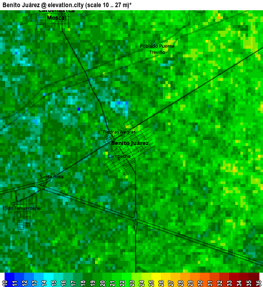
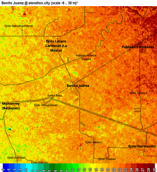
Below is the Elevation map of Benito Juárez, which displays elevation range with different colors. Scale of the first map is from 10 to 27 m (33 to 89 ft) with average elevation of 19.3 meters (=63 ft) [note 1]
These maps also provides idea of topography and contour of this city, they are displayed at different zoom levels. More info about maps, scale and edge coordinates you can find below images.
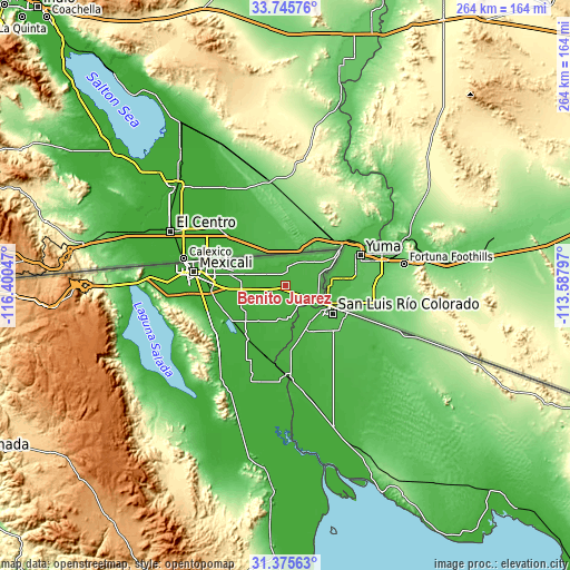
| \ | Map #1 | Map #2 | Topo.Map |
| Scale [m] | 10..27 m | -6..30 m | × |
| Scale [ft] | 33..89 ft | -20..98 ft | × |
| Average | 19.3 m = 63 ft | 19.5 m = 64 ft | × |
| Width | 8.24 km = 5.1 mi | 16.47 km = 10.2 mi | 263.5 km = 163.7 mi |
| Height | 8.24 km = 5.1 mi | 16.47 km = 10.2 mi | 263.5 km = 163.7 mi |
| ↑Max Latitude | 32.605547° | 32.642559° | 33.74576° |
| Latitude at center | 32.56852° | 32.56852° | 32.56852° |
| ↓Min Latitude | 32.531478° | 32.49442° | 31.37563° |
| ← Min Longitude | -115.038165° | -115.082111° | -116.40047° |
| Longitude center | -114.99422° | -114.99422° | -114.99422° |
| →Max Longitude | -114.950275° | -114.906329° | -113.58797° |
Nearby cities:
Cities around Benito Juárez sort by population:
• Tecolots elevation 22 m
1 km,  101°
101°
• Hermosillo 22 m
9.3 km,  133°
133°
• Ejido Lázaro Cárdenas 19 m
5 km,  330°
330°
• Poblado Lázaro Cárdenas (La Veintiocho) 19 m
22.7 km,  197°
197°
• Ejido Quintana Roo 18 m
13.9 km,  216°
216°
• Ejido Jiquilpan 16 m
9.9 km, 221°
• Ejido Yucatán 16 m
10.1 km,  293°
293°
• Ejido Saltillo 15 m
20.2 km, 217°
• Ejido Vicente Guerrero 13 m
23.6 km, 215°
• Ejido Netzahualcóyotl 17 m
8.9 km,  314°
314°
• Ejido Toluca 16 m
17.5 km,  208°
208°
• Ejido Tabasco 27 m
6.4 km, 96°
Multilingual:
 En español:
Benito Juárez elevación 20 m.
 En France:
Benito Juárez élévation 20 m.
 Auf Deutsch:
Benito Juárez höhe über dem Meeresspiegel ist 20 m.

Sources and notes:
- [note 1] Map square and city borders are not equal. Map elevation data is calculated only from area inside that square.
- [src 1] Elevation data from geonames database provided with same terms of usage.
- [src 2] The elevation map of Benito Juárez is generated using elevation data from NASA's 3 arcsec (90m) resolution SRTM data.
- [src 3] Base (background) map © OpenStreetMap contributors tiles are generated by Geofabrik and OpenTopoMap.
Copyright & License:
This Benito Juárez Elevation Map is licensed under CC BY-SA. You may reuse any part from this page, if you give a proper credit by linking to this URL:
 More info on terms of use page.