Guadalupe Victoria elevation
Guadalupe Victoria (Baja California, Mexicali), Mexico elevation is 13 meters and Guadalupe Victoria elevation in feet is 43 ft above sea level [src 1]. Guadalupe Victoria is a populated place (feature code) with elevation that is 1301 meters (4268 ft) smaller than average city elevation in Mexico.
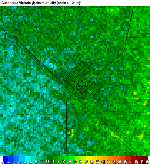
Below is the Elevation map of Guadalupe Victoria, which displays elevation range with different colors. Scale of the first map is from 4 to 21 m (13 to 69 ft) with average elevation of 12 meters (=39 ft) [note 1]
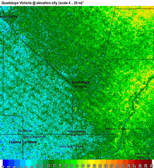
These maps also provides idea of topography and contour of this city, they are displayed at different zoom levels. More info about maps, scale and edge coordinates you can find below images.
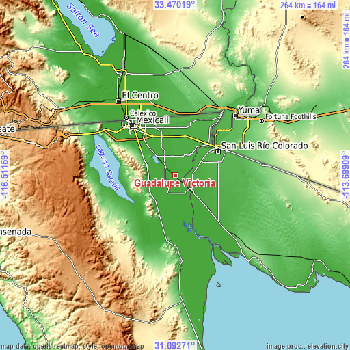
| \ | Map #1 | Map #2 | Topo.Map |
| Scale [m] | 4..21 m | 4..25 m | × |
| Scale [ft] | 13..69 ft | 13..82 ft | × |
| Average | 12 m = 39 ft | 12.3 m = 40 ft | × |
| Width | 8.26 km = 5.1 mi | 16.52 km = 10.3 mi | 264.4 km = 164.3 mi |
| Height | 8.26 km = 5.1 mi | 16.52 km = 10.3 mi | 264.4 km = 164.3 mi |
| ↑Max Latitude | 32.326382° | 32.363509° | 33.47019° |
| Latitude at center | 32.28924° | 32.28924° | 32.28924° |
| ↓Min Latitude | 32.252083° | 32.21491° | 31.09271° |
| ← Min Longitude | -115.149285° | -115.193231° | -116.51159° |
| Longitude center | -115.10534° | -115.10534° | -115.10534° |
| →Max Longitude | -115.061395° | -115.017449° | -113.69909° |
Nearby cities:
Cities around Guadalupe Victoria sort by population:
• Doctor Alberto Oviedo Mota elevation 9 m
9 km,  220°
220°
• Estación Coahuila 12 m
14.6 km,  137°
137°
• Colonia Venustiano Carranza 10 m
8.2 km, 224°
• Ciudad Coahuila (Kilómetro Cincuenta y Siete) 11 m
14.2 km, 137°
• Delta 11 m
11.2 km,  310°
310°
• Poblado Lázaro Cárdenas (La Veintiocho) 19 m
10.1 km,  21°
21°
• Ejido Plan de Ayala 16 m
10.3 km, 137°
• Durango 10 m
14.5 km,  251°
251°
• Ejido Pátzcuaro 19 m
7.8 km,  28°
28°
• Ejido Sonora 6 m
11.8 km,  269°
269°
• Ejido Vicente Guerrero 13 m
12.3 km,  344°
344°
• Estación Pescaderos 14 m
4 km, 309°
Multilingual:
 En español:
Guadalupe Victoria elevación 13 m.
 En France:
Guadalupe Victoria élévation 13 m.
 Auf Deutsch:
Guadalupe Victoria höhe über dem Meeresspiegel ist 13 m.

Sources and notes:
- [note 1] Map square and city borders are not equal. Map elevation data is calculated only from area inside that square.
- [src 1] Elevation data from geonames database provided with same terms of usage.
- [src 2] The elevation map of Guadalupe Victoria is generated using elevation data from NASA's 3 arcsec (90m) resolution SRTM data.
- [src 3] Base (background) map © OpenStreetMap contributors tiles are generated by Geofabrik and OpenTopoMap.
Copyright & License:
This Guadalupe Victoria Elevation Map is licensed under CC BY-SA. You may reuse any part from this page, if you give a proper credit by linking to this URL:
 More info on terms of use page.