Paso de Cuarenta elevation
Paso de Cuarenta (Jalisco, Lagos de Moreno), Mexico elevation is 1939 meters and Paso de Cuarenta elevation in feet is 6362 ft above sea level [src 1]. Paso de Cuarenta is a populated place (feature code) with elevation that is 625 meters (2051 ft) bigger than average city elevation in Mexico.
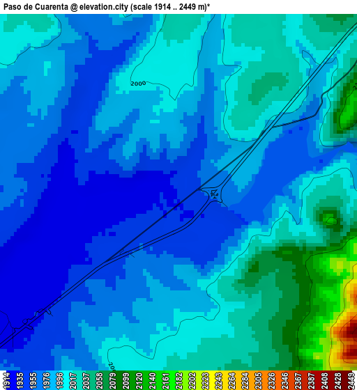
Below is the Elevation map of Paso de Cuarenta, which displays elevation range with different colors. Scale of the first map is from 1914 to 2449 m (6280 to 8035 ft) with average elevation of 1993.7 meters (=6541 ft) [note 1]
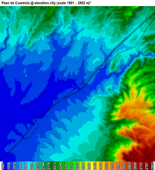
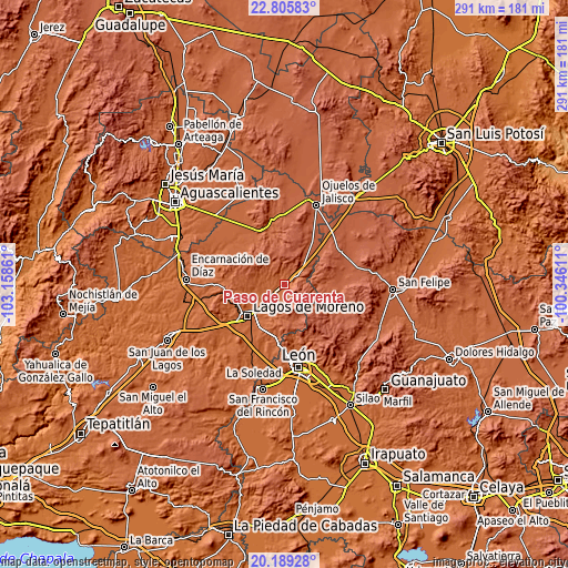
These maps also provides idea of topography and contour of this city, they are displayed at different zoom levels. More info about maps, scale and edge coordinates you can find below images.
| \ | Map #1 | Map #2 | Topo.Map |
| Scale [m] | 1914..2449 m | 1901..2802 m | × |
| Scale [ft] | 6280..8035 ft | 6237..9193 ft | × |
| Average | 1993.7 m = 6541 ft | 2093.6 m = 6869 ft | × |
| Width | 9.09 km = 5.6 mi | 18.18 km = 11.3 mi | 290.9 km = 180.8 mi |
| Height | 9.09 km = 5.6 mi | 18.18 km = 11.3 mi | 291 km = 180.8 mi |
| ↑Max Latitude | 21.544321° | 21.58519° | 22.80583° |
| Latitude at center | 21.50344° | 21.50344° | 21.50344° |
| ↓Min Latitude | 21.462548° | 21.421644° | 20.18928° |
| ← Min Longitude | -101.796305° | -101.840251° | -103.15861° |
| Longitude center | -101.75236° | -101.75236° | -101.75236° |
| →Max Longitude | -101.708415° | -101.664469° | -100.34611° |
Nearby cities:
Cities around Paso de Cuarenta sort by population:
• Lagos de Moreno elevation 1889 m
25.2 km,  229°
229°
• Geovillas Laureles del Campanario 1872 m
26.1 km,  222°
222°
• El Puesto 2061 m
25.8 km,  301°
301°
• Granadillas (La Colonia) 1884 m
20.7 km, 228°
• Primero de Mayo (Chupaderos) 1916 m
8.8 km,  241°
241°
• Matanzas 2209 m
17.6 km,  34°
34°
• San Pedro de Ibarra 2145 m
22 km,  95°
95°
• El Ojuelo 1930 m
14.3 km, 217°
• Dieciocho de Marzo 1915 m
5.3 km, 244°
• San Cristóbal 2019 m
27.8 km,  315°
315°
• Guadalupe Victoria 2195 m
26 km, 32°
• El Bajío (La Laguna) 1879 m
24.7 km, 236°
Multilingual:
 En español:
Paso de Cuarenta elevación 1939 m.
 En France:
Paso de Cuarenta élévation 1939 m.
 Auf Deutsch:
Paso de Cuarenta höhe über dem Meeresspiegel ist 1939 m.

Sources and notes:
- [note 1] Map square and city borders are not equal. Map elevation data is calculated only from area inside that square.
- [src 1] Elevation data from geonames database provided with same terms of usage.
- [src 2] The elevation map of Paso de Cuarenta is generated using elevation data from NASA's 3 arcsec (90m) resolution SRTM data.
- [src 3] Base (background) map © OpenStreetMap contributors tiles are generated by Geofabrik and OpenTopoMap.
Copyright & License:
This Paso de Cuarenta Elevation Map is licensed under CC BY-SA. You may reuse any part from this page, if you give a proper credit by linking to this URL:
 More info on terms of use page.