Ranchito de Castro elevation
Ranchito de Castro (Sinaloa, Guasave), Mexico elevation is 21 meters and Ranchito de Castro elevation in feet is 69 ft above sea level [src 1]. Ranchito de Castro is a populated place (feature code) with elevation that is 1293 meters (4242 ft) smaller than average city elevation in Mexico.
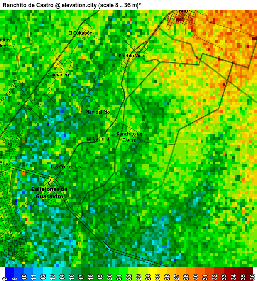
Below is the Elevation map of Ranchito de Castro, which displays elevation range with different colors. Scale of the first map is from 8 to 36 m (26 to 118 ft) with average elevation of 20.5 meters (=67 ft) [note 1]
These maps also provides idea of topography and contour of this city, they are displayed at different zoom levels. More info about maps, scale and edge coordinates you can find below images.
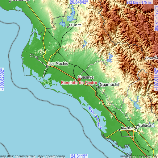
| \ | Map #1 | Topo.Map |
| Scale [m] | 8..36 m | × |
| Scale [ft] | 26..118 ft | × |
| Average | 20.5 m = 67 ft | × |
| Width | 8.81 km = 5.5 mi | 282 km = 175.2 mi |
| Height | 8.81 km = 5.5 mi | 282 km = 175.2 mi |
| ↑Max Latitude | 25.626509° | 26.84842° |
| Latitude at center | 25.58688° | 25.58688° |
| ↓Min Latitude | 25.547238° | 24.3119° |
| ← Min Longitude | -108.461615° | -109.82392° |
| Longitude center | -108.41767° | -108.41767° |
| →Max Longitude | -108.373725° | -107.01142° |
Nearby cities:
Cities around Ranchito de Castro sort by population:
• Guasave elevation 18 m
5.5 km,  246°
246°
• Los Angeles 22 m
6.6 km,  285°
285°
• El Burrión 17 m
5.4 km,  174°
174°
• El Nio 31 m
4.5 km,  22°
22°
• El Varal (San Sebastián Número Uno) 27 m
6.3 km,  353°
353°
• Las Moras 29 m
8.8 km,  332°
332°
• Guasavito 22 m
4.2 km,  204°
204°
• San Pedro Guasave 22 m
6.7 km,  215°
215°
• Pueblo Viejo 24 m
3 km,  3°
3°
• Caimanero 22 m
3.2 km,  309°
309°
• Ladrilleras de Ocoro 18 m
3.4 km, 291°
• Gambino 29 m
7.8 km, 23°
Multilingual:
 En español:
Ranchito de Castro elevación 21 m.
 En France:
Ranchito de Castro élévation 21 m.
 Auf Deutsch:
Ranchito de Castro höhe über dem Meeresspiegel ist 21 m.

Sources and notes:
- [note 1] Map square and city borders are not equal. Map elevation data is calculated only from area inside that square.
- [src 1] Elevation data from geonames database provided with same terms of usage.
- [src 2] The elevation map of Ranchito de Castro is generated using elevation data from NASA's 3 arcsec (90m) resolution SRTM data.
- [src 3] Base (background) map © OpenStreetMap contributors tiles are generated by Geofabrik and OpenTopoMap.
Copyright & License:
This Ranchito de Castro Elevation Map is licensed under CC BY-SA. You may reuse any part from this page, if you give a proper credit by linking to this URL:
 More info on terms of use page.