San Blas elevation
San Blas (Zacatecas, Loreto), Mexico elevation is 2063 meters and San Blas elevation in feet is 6768 ft above sea level [src 1]. San Blas is a populated place (feature code) with elevation that is 749 meters (2457 ft) bigger than average city elevation in Mexico.
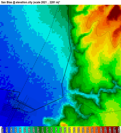
Below is the Elevation map of San Blas, which displays elevation range with different colors. Scale of the first map is from 2021 to 2281 m (6631 to 7484 ft) with average elevation of 2093.9 meters (=6870 ft) [note 1]
These maps also provides idea of topography and contour of this city, they are displayed at different zoom levels. More info about maps, scale and edge coordinates you can find below images.
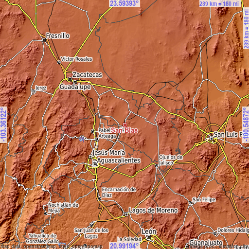
| \ | Map #1 | Topo.Map |
| Scale [m] | 2021..2281 m | × |
| Scale [ft] | 6631..7484 ft | × |
| Average | 2093.9 m = 6870 ft | × |
| Width | 9.04 km = 5.6 mi | 289.3 km = 179.8 mi |
| Height | 9.04 km = 5.6 mi | 289.3 km = 179.8 mi |
| ↑Max Latitude | 22.339643° | 23.59393° |
| Latitude at center | 22.29899° | 22.29899° |
| ↓Min Latitude | 22.258325° | 20.99194° |
| ← Min Longitude | -101.998915° | -103.36122° |
| Longitude center | -101.95497° | -101.95497° |
| →Max Longitude | -101.911025° | -100.54872° |
Nearby cities:
Cities around San Blas sort by population:
• Loreto elevation 2032 m
4.6 km,  229°
229°
• San Marcos 2056 m
2.4 km,  172°
172°
• Tierra Blanca 2025 m
12.6 km,  295°
295°
• Maravillas 2051 m
12.9 km,  330°
330°
• Guadalupe de Atlas 2023 m
8.6 km,  245°
245°
• Crisóstomos 2027 m
8.8 km,  208°
208°
• Santa María de los Ángeles 2124 m
9.4 km,  100°
100°
• Ejido Hidalgo 2023 m
8.6 km,  271°
271°
• Colonia Hidalgo (El Tecolote) 2023 m
9 km,  292°
292°
• Bimbaletes Aguascalientes (El Álamo) 2018 m
9.8 km,  222°
222°
• Noria del Borrego (Norias) 2032 m
9 km,  261°
261°
• Jarillas 2047 m
11.2 km, 268°
Multilingual:
 En español:
San Blas elevación 2063 m.
 En France:
San Blas élévation 2063 m.
 Auf Deutsch:
San Blas höhe über dem Meeresspiegel ist 2063 m.

Sources and notes:
- [note 1] Map square and city borders are not equal. Map elevation data is calculated only from area inside that square.
- [src 1] Elevation data from geonames database provided with same terms of usage.
- [src 2] The elevation map of San Blas is generated using elevation data from NASA's 3 arcsec (90m) resolution SRTM data.
- [src 3] Base (background) map © OpenStreetMap contributors tiles are generated by Geofabrik and OpenTopoMap.
Copyright & License:
This San Blas Elevation Map is licensed under CC BY-SA. You may reuse any part from this page, if you give a proper credit by linking to this URL:
 More info on terms of use page.